Lockheed Martin
A few years ago, Corporal Doug Green of the Royal Canadian Mounted Police used his Draganflyer X4-ES UAS to save a man’s life.
The young man caught the edge of the shoulder as he was driving along Highway 5 in Canada, causing him to lose control and roll his car. But when emergency responders arrived on scene that night, the driver was nowhere to be found.
This was in 2013, and the RCMP had been using Draganfly’s Draganflyer X4-ES for various missions since 2011. One of the officers on scene remembered that, and when STARS Air Ambulance had trouble finding the victim, they called Green, a Forensic Collision Reconstructionist, and asked him to bring the UAS to the location.
It was a cold night, and emergency responders knew it might be too late if they didn’t find the missing driver until the morning. In an effort to help locate him more quickly, workers back at the station identified the victim and called his cell phone.
“When he answered he was pretty disoriented. He said he had no shoes on and was cold and wet. He had just walked through a bunch of swamps,” Green said. “The cell phone provider gave us the GPS location of where that call was coming from, and it turned out to be two miles south of the rollover scene. We went to that location, but by the time we got there he had wandered off some more. We did a ground search and found nothing, so we decided to deploy the Draganflyer.”
The Draganflyer was equipped with a small FLIR thermal imaging camera, which picked up three heat signals while in the air. The first heat signal was 200 meters away. They used the portable UAS to direct two firemen to that heat signal, which is how they finally found the driver. He was curled up on the tree line and very near the end of hypothermia.
That life-saving mission is one of the most memorable the RCMP has flown over the years, but it’s one of many. They use the Draganflyer X4-ES as well as the smaller Draganflyer Guardian for a variety of missions, such as crime scene investigation, collision reconstruction and emergency response.
And they’re not the only law enforcement agency turning to UAS. Both small and large agencies are realizing the benefits of unmanned systems, and are learning how to incorporate them into a variety of applications, including crime scene investigation, car accidents, search and rescue and natural disasters.
Crime Scene Investigations
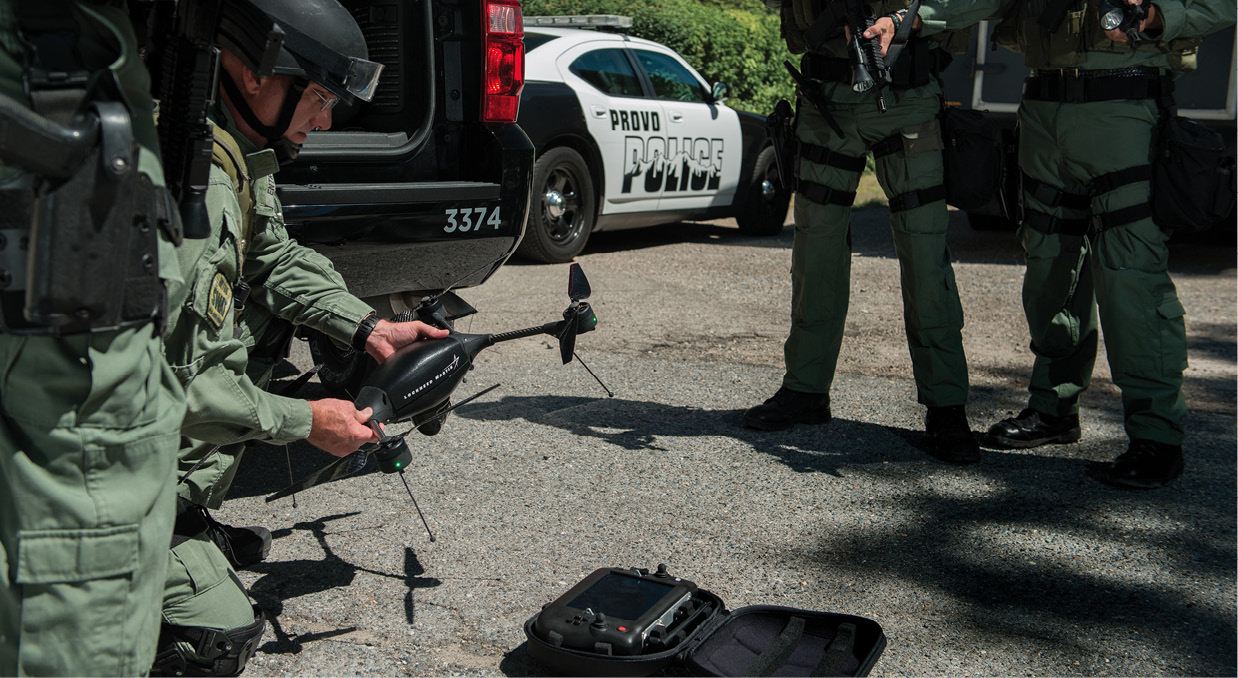
The Mesa County Sheriff’s Office in Colorado first began looking at UAS in 2008, and became the first law enforcement agency in the United States to start an operational UAS program in 2010, said Quartermaster Ben Miller, the unmanned aircraft program manager. They fly the Falcon fixed-wing from Falcon Unmanned for search and rescue missions, and the Draganflyer X4-ES for accident and crime scene investigations.
They’ve completed about 90 missions and 300 flight hours, Miller said, and can fly anywhere in Mesa County. Six officers are trained to operate the UAS, and primarily use the Draganflyer for crime scene investigations.
At first, they used the pictures taken from the air just to gain a different perspective of a crime scene, Miller said. The cameras onboard the Draganflyer takes photos straight down, and through orthomosaic reconstruction they can use those images to create an accurate map of the crime scene.
“There’s a lot you can do mathematically with a photo taken straight down,” he said. “Picture a homicide scene. You can fly a grid pattern, collect 50 photos and then put them in the software. The software aligns them and makes an accurate map. That map is then captured forever as a digital image. Homicide investigations go on for a while. This gives us a map of the scene on the day the homicide occurred that we can refer to in the future.”
The team has added a process that enables the UAS to capture photos from different angles. They put those photos into the software to create a point cloud, giving them a realistic, geometrically accurate 3-D model of the scene, Miller said. They can animate the model and even recreate how a victim was chased during a homicide.
The geospatial information tells them exactly where everything was placed during the crime and the distance between various objects, Miller said. Often, distance is the key variable when investigating a homicide. Investigators can look at the map and know that, for a suspect to have committed the crime, he would have had to get from Point A to Point B in 3.5 seconds. They can then go into the model and measure the distance, and determine if it was possible to travel that distance in the known timeframe.
Creating these maps is something they’ve never been able to do before, Miller said, and is information that can make all the difference during a jury trial.
Sgt. Matthew Rogers, with the Michigan State Police aviation unit, uses the SkyRanger from Aeryon for crime scene investigation. He said the UAS excels at providing straight down pictures of the scene, and agrees the map created from the photos is invaluable during a trial. The MSP recently received authorization from the Federal Aviation Administration (FAA) to fly their UAS statewide, the first authorization of its kind.
“The SkyRanger provides documentation of crime scenes from an aerial perspective,” Rogers said. “The prosecutor can present these aerial photos to the jury to help them understand what went on there.”
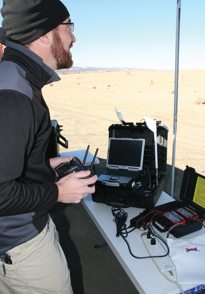
Mesa County Sherriff’s Office Quartermaster Ben Miller at the command center. The department uses the Draganflyer X4-ES for accident and crime scene investigations.
Traffic Accidents
When Green and his team first talked about implementing UAS in 2010, they were focused on using them to take photos over collision scenes, he said. Just like with crime scenes, the UAS can take images and collect footage from above a fatal or serious injury collision.
“You can see more in the overall scene from the higher angle than you can from a straight picture off the ground,” Green said. “We never had the capability to gather these aerial photos before. Our first attempts of any type of aerial photo was to put a 35 mm camera on a painter’s pole and trigger it to get a picture of the area of impact. We could get 30 feet at the most. Now we can get a straight down picture of the scene.”
Green and the rest of the five-member forensic collision reconstruction team work 50 to 60 collision scenes a year, he said. All five team members are trained to use the UAS, and have a unit in their vehicle at all times.
When putting a report together, Green can use the map the software creates to describe the scene and the sequence of events that led to the crash. He can point out exactly where the vehicle came to rest. And just like with crime scenes, the stitched together images can help a judge and jury see what happened if one of these collision cases goes to trial.
Without the UAS, investigators can’t take photos of the entire scene. Instead they start taking photos away from the scene and work their way up, capturing it in bits and pieces—making it difficult for juries to keep track and actually visualize what happened. With the UAS, they can capture the entire collision scene in one shot.
Using UAS for traffic accidents also gives investigators something to reference to check their measurements, Miller said. If they use the push wheel to measure skid marks to determine if the driver was speeding, they only have one shot to get that measurement right. But if they can put the measurements in a map created with the images taken from the UAS, they know what’s in the map is within millimeters accuracy of the actual skid mark. They can look at that map two years later and reaffirm the measurements are accurate, which can be beneficial during a trial.
Search And Rescue
When the Michigan State Police first began flying the SkyRanger, they thought they’d mostly put it in the air for search and rescue missions. But with the beyond line of sight flight restrictions, they’ve found that really isn’t the best use for law enforcement.
“Though it helps with search and rescue we’ve found its place is really aerial photography,” Rogers said. “With the line of sight limitation we can only fly it a half mile. So we fly it a half mile, land it, pick it up and move it another half mile down, and then we have to do it again. A helicopter can cover the whole area in a much shorter period of time.”
While Green has used the Draganflyer in search and rescue missions, including the driver he saved two years ago, he said a UAS is really only useful in these missions if you can get it on the scene quickly and have a defined search area. Eight hours after someone goes missing is too late. For a UAS to have any chance of finding someone, the search should be limited to no more than a quarter section of land, Green said.
The amount of data that comes in during a search and rescue mission also presents a challenge, Miller said. He recently used the Draganflyer to search for a missing 65 year old woman. While the UAS covered a much larger distance than rescuers could by foot, he remembers watching eight hours of footage and wondering if he somehow missed her. They ended up finding her on foot the next day.
“We’re getting video in real time, and we’re watching video looking for the subject. We’re inundated with video, and sometimes you have an uneasiness that you have so much data that you can’t process it,” Miller said. “We don’t need to reduce the data, but we need more help processing it. That’s the next step. The industry has the data collection piece down. The next step is getting more help going through that information.”
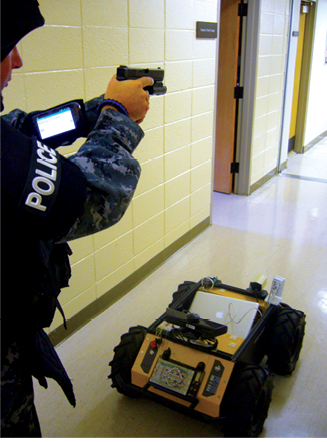
Starkville, MS Officer using an Android device to receive messages and images from the Clearpath Husky robot for determining the robot’s intent for upcoming movements.
Other Uses
The applications for UAS in law enforcement seem to be endless, and Rogers said MSP has flown UAS in more than 20 missions since they began operations in February.
Beyond crime scene and collision reconstruction, those missions included fire scenes, a house explosion on the lake and capturing photos of the damage a tornado left behind.
“We used manned aircraft and unmanned aircraft to document the tornado’s path of destruction,” Rogers said. “The manned aircraft gave us a lot of photos and videos of the entire path, and the UAS came into play by giving us more detailed photos closer to the buildings so we could examine the damage.”
He can see the MSP deploying UAS for that type of natural disaster mission again, and said it also would be useful during a hazmat incident or a train derailment.
The Challenges
Beyond waiting for official regulations from the FAA, public perception is another big challenge law enforcement agencies face when it comes to incorporating UAS. Many people still have a negative view of what they call “drones,” and think law enforcement wants to use them for surveillance, or plan to fly the large military Predator drones they’ve seen on TV.
Agencies need to educate the public on the benefits of UAS, Miller said, and be prepared to not only answer their questions, but to also start a conversation. Agencies must show the public why they’re spending money on UAS, and reassure them it isn’t about invading their privacy—it’s about providing better services and increasing safety at a reduced cost.
But in some cases, it’s not just the public that needs convincing. It’s also the agencies, said David Proulx, Aeryon VP product and marketing. Many officers don’t understand the capabilities, or how easy it is to operate a UAS—especially one designed specifically for law enforcement applications.
“We need education at the police force level about just how easy it is to operate a UAS,” Proulx said. “There’s a lingering mental perception that it requires a degree of specialization that is difficult to achieve.”
Many agencies also don’t realize that UAS like Aeryon’s SkyRanger are designed for these types of applications and can fly in harsh conditions, day or night, Proulx said. They think they can only fly them during calm days, a misconception that may keep them from pursuing a UAS program.
The thought of developing a policy for flying UAS also keeps agencies grounded, Miller said, but the process isn’t as exhaustive as many agencies think. The policy Miller submitted to his policy committee was 30 pages. The committee cut it down to 17 because many of the areas hit on were covered in other policies.
Since the MSP received authorization, they’ve fielded more than 100 calls and emails from agencies asking about their policies and procedures. Rogers and the other officers are happy to answer their questions, and even offer their UAS services for free to any law enforcement agency in the state.
“There’s no need for another agency to re-write a manual if we already have the information,” Rogers said. “And we want to make sure everybody that operates these systems are operating them within the rules and regulations.”
The Future
As UAS continue to evolve, Proulx predicts more law enforcement agencies will use them. He sees agencies centrally managing the aircraft and making them available for various applications. Aircraft like the SkyRanger come equipped with mission specific hardware, software and sensor packages, making them easy to use and ready to deploy at a moment’s notice.
Miller sees a time when agencies deploy UAS on a daily basis, and rather than specific teams operating them, any trained officers will be able to deploy them when necessary. The technology will eventually get to a place where it’s viewed as disposable, making it less of an issue if a small UAS is damaged during a crash.
The agencies that have already made the move to unmanned want to not only stay on the leading edge and use the most up-to-date technology that’s available, they want to create a path for other agencies to follow. They hope to lead the way as UAS become an everyday tool officers can rely on for a variety of applications.
As more agencies fly UAS and have conversations with the communities they serve about the benefits, agreed those who spoke with Inside Unmanned Systems, more people will accept them as a worthwhile technological advancement. Gaining public trust is key, as is making sure officers are properly trained to operate the systems, systems that can help improve public safety, save agencies money, improve efficiencies and even save lives.
“It’s really still in the early days of using UAS in public safety,” Proulx said. “As more agencies get their hands on this technology, we’ll see an even greater spread of applications for these aircraft.”