C-Worker 6 surface vehicle. Photo courtesy David Brannon, NORAC
Marine companies wanting to develop autonomous vehicles, assess a new venture, or tap into the latest research on the ocean environment now have two new research centers created specifically to help them with technical expertise, testing resources and coastal data.
Funded with seed money from economically minded state officials, the Center for Marine Robotics at the Woods Hole Oceanographic Institution in Massachusetts, and the National Oceans and Applications Research Center (NOARC) at Stennis Space Center in Mississippi, are planning to use their respective strengths to attract participation from the private sector.
The Center for Marine Robotics will be led by James Bellingham, who founded the Underwater Vehicles Lab at the Massachusetts Institute of Technology and went on to co-found Bluefin Robotics. He served as chief technologist at the Monterey Bay Aquarium Research Institute (MBARI) in California before returning to Massachusetts this fall.
“Woods Hole has really pioneered autonomous underwater vehicle systems,” he said, noting the many successful companies like Hydroid got their start in the state. When a scientist has a robot deep in some faraway ocean, he said, the odds are that vehicle was built in Cape Cod or in southeastern Massachusetts by companies that were spun out of Woods Hole and MIT.
His perspective on how commercial operators fit into the overall science and marine community, he said, has been shaped by his own experience as an entrepreneur.
‘These different organizations are tuned to do different things and you really need all of them in order to have a healthy ecosystem,” he told Inside Unmanned Systems. “…We want to help these commercial companies grow. We see ourselves as a place where we can test some of the more advanced concepts; maybe foster a whole set of crazy ideas of which, if one or two work, we’ll really break through.”
The center’s help will take the form of forums for start-up firms, technical research and meetings with experts and a suite of new capabilities to develop and test new systems.
Help for Start-Ups
The first entrepreneurs meeting, which is free to attend, is in July, Bellingham said.
“We will have some people there who are experts in high-tech start-ups to have a conversation about what’s different between the marine field and other fields,” he said. There will also be an effort to begin lining up a pool of mentors.
Other, more in-depth meetings will be open to firms with membership in the center, which starts at $50,000 and goes up to the $1 million dollar level. Those at the opening $50,000 level have the opportunity to attend the center’s annual meeting and arrange get-togethers with principal investigators.
“You can kind of look at it as contingency consulting,” said Bellingham. For example, he said “there’s a group of people here who are working on methods of detecting hydrocarbons in the water column. And so as a consequence a number of companies are coming here to understand the techniques—what the sensitivity levels are, what is the applicability to their problems.”
For an additional $50,000 firms can send their staff to a specialized meeting on either defense issues or a commercial sector like oil and gas.
The next level up is $550,000, “that is kind of a consortium member,” Bellingham explained. Part of that money goes to a postdoctoral student and another part goes to a core research fund.
The pooled research money supports projects selected on a competitive basis. The firms are members of the steering committee that shapes the solicitations and makes the final selection from the submitted research proposals. It is a way for members to pool resources to attack common problems, said Bellingham.
“One of the discussions that we’ve been having revolves around the ability to assess the state of the environment, the health of marine habitats and the likely impact of human activities,’ Bellingham said. “So those are very common themes, particularly to industrial activities in the ocean, which either might impact the permitting process, impact their monitoring or impact their operations.”
Firms joining at the $1 million level are members of the consortia, said Bellingham, but are also sponsoring their own research at the center.
Woods Hole is already working with a range of companies, said Andy Bowen, director of the institution’s National Deep Submergence Facility.
“We did a project, for example, with the Sentry AUV (autonomous underwater vehicle) in collaboration with Exxon Mobil last year in the Gulf of Mexico,” said Bowen, “looking at new methods of characterizing subsea seeps—using scientifically derived techniques for basin scale mapping.”
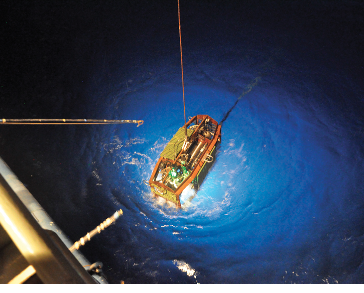
Sentry autonomous underwater vehicle
Under Pressure
Thanks to a new $5 million grant from the Massachusetts’ Collaborative Research and Development Matching Grant Program, the center also will be able to offer its members use of four new, specialized facilities including a rapid prototyping center, an advanced pressure test facility, an indoor robotic test tank and an in-ocean test environment.
The idea, Bellingham said, is to build better test facilities onshore. “The Commonwealth has funded really what I see, as a way of accelerating ideas from the back of the envelope to test in a real ocean environment.”
For example, he said, there are certain electronic systems that have the “really unfortunate characteristic” that they usually don’t fail their first pressure test but do fail on the fifth or sixth cycle. Those systems can be tested and retested at the center.
In fact, with the prototyping center, pressure test facility and indoor test tank, he said, “you make something, you pressure test it, and then we have a test tank which is going to be built…which allows you to operate some of your systems actually in the test tank environment.”
And that testing can extend into the ocean itself.
Woods Hole has a cabled observatory off Martha’s Vineyard to which the center will be adding communications and acoustic navigation—making it the equivalent of an underwater hotspot. Researchers will be able to talk to their equipment “from basically anywhere you have connection to the Internet,” said Bellingham.
“It’s enormously powerful,” he told Inside Unmanned Systems, “because then that lets you plug things in in the undersea environment, which you can then interact with directly from your laboratory.”
RESTORing Innovation
The National Oceans and Applications Research Center (NOARC) in Hancock County, Mississippi, is hoping to emulate Woods Hole’s success.
Funded with $500,000 in seed money in 2012 the NOARC will get its near-term support from RESTORE ACT funds, which are fines resulting from the Deepwater Horizon oil spill. Much of that money, which is only now being released, will go toward efforts to rehabilitate damaged areas.
NOARC will support the restoration effort by tapping the expertise of NASA, the National Oceanic and Atmospheric Administration and the U.S. Navy to give scientists a “space to sea floor” picture of the Gulf of Mexico watershed, according to a statement from the office of Mississippi Gov. Phil Bryant. That information will be integral to restoring, enhancing and managing the coastal areas damaged by the oil spill
But the value of that data, and the technology used to gather it, has utility beyond RESTORE activities, said NOARC’s General Manager David Brannon.
Gov. Bryant gave me some very specific directions, “a very simple but very strategic and far-reaching charter,” said Brannon. “That is to take the technological base that we have here in Mississippi in marine technology, oceanography, autonomous systems, geospatial systems and telecommunication systems—take that…technological footprint, and build on it.”
Brannon said the technology they will develop to do things like assess environmental restoration efforts that will have value in other market areas.
“It almost takes exactly the same thing,” he said, “to do other kinds of mapping work, other kinds of monitoring work. Other kinds of marine engineering services require similar capabilities.”
Working Autonomously
Autonomous technology is very much a part of their plans, he said, adding that NOARC already has a fleet of autonomous vehicles able to operate at depths ranging from shallow coastal waters to the ocean floor.
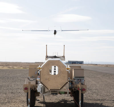
NOARC, for example, demonstrated the C-Worker 6 surface vehicle in December.
Developed by the United Kingdom’s ASV Ltd., for oil field services, the 6-meter craft can do subsea positioning, surveying and environmental monitoring without seabed anchoring or a support ship.
NOARC also is investing in a 6-rotor helicopter for mapping wetlands. The unmanned platform will know exactly where it is in three-dimensional space with real-time kinematic GPS, and they are working with several other organizations to develop multispectral and hyperspectral sensors.
“We need to be somewhere between multi- and hyper- (spectral),” said Brannon. “We need about an eight or 10 channel sensor that essentially duplicates what DigitalGlobe and others are flying in space.” Part of the development plan, he said, is an easier operating capability using a tablet or an iPhone.
The craft, which will be capable of 3-D photogrammetric terrain analysis, could be used for monitoring construction sites, he said, including drain and fill operations and sand pumping used to renew barrier islands.
Emergency Operations
The Mississippi center is also considering using the six-rotor craft for a new type of service—for-profit emergency response support.
“That’s something we are developing that we are going to be testing with first responders and emergency response folks,” said Brannon. “We have a lot of tornadoes in Mississippi that just tear the living heck out of a corridor. And to be on-site with a copter, especially when you already have the data from what was there, then you can do immediate change detection.”
Once NOARC gets to the point that it can collect data routinely, it will be able to create wide-area baseline maps—the same sort of maps needed to do environmental monitoring.
With such a ‘before picture’ in hand, he said, assessing the damage will be easy.
“You know exactly which homes were damaged,” said Brannon. “You know the extent of the damage and you can map the wind field of that tornado system.”