UAS can be used in routine and emergency inspections at refineries and chemical plants. They can be used to generate and/or support a baseline comparison for engineers as they evaluate sensor data on the supporting infrastructure, rust formation, integrity of the pipework, invisible leaks to the naked eye, and condition of the flare tips.
Overseeing BP’s oil field in Prudhoe Bay, Alaska, isn’t an easy task. The harsh weather conditions lead to ice break-ups, floods and ice floes that alter the field’s topography—making monitoring and maintaining the terrain a challenging, expensive and even dangerous task.
The 250,000-acre oil field is the largest in North America and features a 200-mile road system, 400 miles if you count the offshoot byways. The drill rigs transported on this gravel network are up to 28 feet wide, 132 feet long and weigh up to 3.5 million pounds, with a driver at each end.
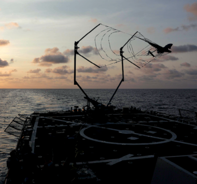
In 2006, BP began looking into using Unmanned Aircraft Systems, or UAS, as a way to help track developments across this swampy tract. In June 2014 BP chose AeroVironment to provide 3-D mapping, Geographic Information System (GIS) services and other information using its Puma AE unmanned aircraft. The five-year contract was significant, marking the first time UAS would be used to perform routine commercial services over land in compliance with Federal Aviation Administration regulations.
Over the last year or so, BP has used maps produced with data from a UAS-based LiDAR (Light Detection and Ranging) sensor. These maps, along with precision GPS guidance systems, help drivers keep the drill rigs centered on the roadways. The highly accurate maps also make it possible to take a road grater and drive a convoy to rescue someone stuck during a blizzard.
“Using UAVs (Unmanned Aerial Vehicles) and the latest light detection and ranging equipment, which incorporates remote sensors that use laser pulses to collect 3-D images, the team is able to create highly accurate, real-time models that help drivers stay on course along gravel roads, even in low-visibility, harsh conditions,” said Curt Smith, technology director in BP’s Digital Innovation Organization. “The UAS also help scan BP’s pipeline network and identify areas that need repair from frost damage. The system has improved the integrity of the company’s operations by making them safer and more efficient.”
One of the advantages of using in-house UAS, drones, is BP staff can easily check on well pads and pipelines monthly—or as often as they’d like.
BP isn’t the only energy company looking to UAS to cut costs and provide more efficient, safer operations. The industry as a whole is starting to realize the many benefits this technology can provide. To help meet increasing demand, more UAS manufacturers are offering their services to oil and gas companies, from those who operate onshore oil fields like Prudhoe Bay in Alaska to firms with offshore oil wells in the Gulf of Mexico to chemical plants and refineries.
On January 27 Unmanned Ad-hoc Industries’ Data Collection Team I traveled to Tyler, Texas for Intelligent Data Collection (IDC) of SCANDRILL’s Scan Vision.
From Upstream to Downstream
One of the biggest challenges at both offshore and onshore facilities is corrosion under insulation, or CUI, said Dr. Peter McClean Millar, director for engineering subsea lifecycle services for Aker Solutions. An offshore company, Aker Solutions is very interested in employing UAS, and has been working with Unmanned Ad-Hoc Industries, or UAI, for the last year and a half to come up with applications that save time, money and lives. UAI focuses on the oil and gas industry, and has about 20 clients in the upstream, midstream and downstream sectors.
The problem? The pipelines and vessels are covered with thick insulation that you can’t see through unless you strip the insulation off. If any water gets behind or under the insulation, there’s a good chance it will start to corrode the pipe and lead to loss of containment, a costly and dangerous problem. CUI has caused explosions in chemical plants, Millar said, meaning the ability to spot it early can help prevent injuries, even save lives.
“To find it you have to strip all the insulation off the pipes and inspect them. There are hundreds of miles of pipe,” he said, noting they try to look at areas where there’s a high likelihood of corrosion. “With the hyper- and multi-spectral sensors on the UAS, we can determine not just if there’s heat lost through the pipe, but if there’s actual corrosion.”
The UAS can perform a baseline survey of the insulation, Millar said, and then use that to help spot corrosion or rust in later flights. When there’s CUI, the rusty water will leak out. If it’s spotted early, workers can make repairs before too much damage is done.
“This type of technology could help prevent explosions,” Millar said. “It’s a more effective way of gathering information and using it to determine trends for corrosion.”
Unmanned aircraft also enable inspectors at both onshore and offshore facilities to get closer to pressure vessels, pipe work or whatever they might need to examine without using scaffolding. A UAS with a camera or other sensor is cheaper, quicker and safer, and enables workers to perform inspections on their own timeline, without having to wait weeks for an expensive scaffolding crew.
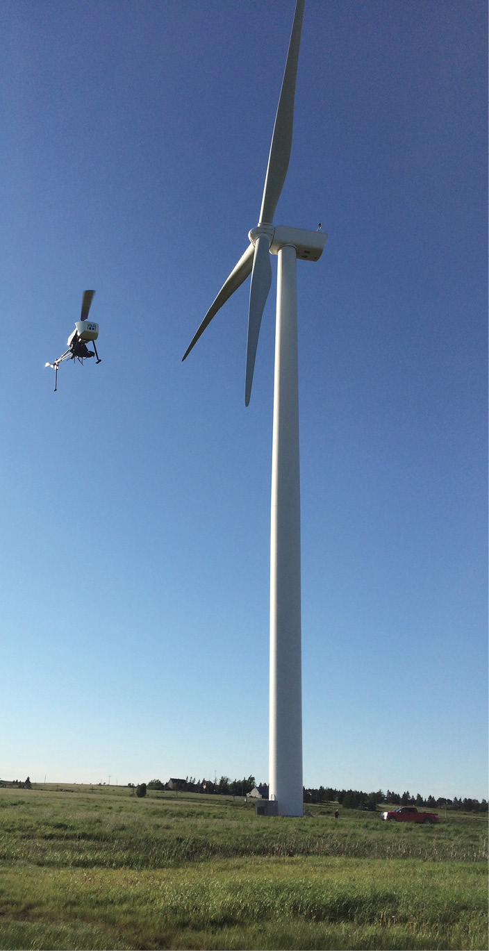
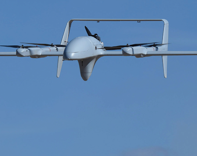
ING’s Responder can be used for a variety of other applications. Here it’s inspecting a wind turbine in Nova Scotia.
Upstream
Offshore oil rigs can use UAS technology to support asset integrity management—an assessment process applied continuously throughout design, construction, installation and operation to ensure facilities are fit for purpose. UAI’s Intelligent Data Collection, or IDC, employs remote sensing to bring clients the data they need without having to shut down equipment or put workers in dangerous situations, UAI CEO Clay Kroschel said.
When a facility needs to add on to an oil rig or match new pipelines to existing ones, someone is typically sent out to the field to take measurements and then use a computer-aided drafting (CAD) program to create blueprints of what the new facilities will look like. Kroschel can use UAI’s HEFF (High Endurance Folding Frame) aircraft to create a 3-D point cloud of the facility. This technology not only eliminates the need to send workers out into the field, it offers 3 cm accuracy, reducing the chance of mistakes.
“I can bring in the file and upload it into a CAD-like program and draw the blueprints off that CAD program,” Kroschel said. “That mitigates days of overhead and traveling. Typically guys would need to fly out to the oil rig and be out there for four or five days. Helicopters are expensive and take up valuable real estate on the rig. I can go out there on a boat and do a 15 or 20 minute flight and get the whole oil rig in a 3-D point cloud, then bring that back to the client and put it in a CAD program.”
They can perform that flight to collect data as often as they want, providing a more accurate, up-to-date blueprint than anything on file, he said.
Millar would like to employ UAS technology to monitor the integrity of fire prevention insulation as well as any pieces of equipment sitting in readiness over a long period of time that need periodic inspections. It can be used to detect corrosion, fatigue or deterioration before they become a major problem.
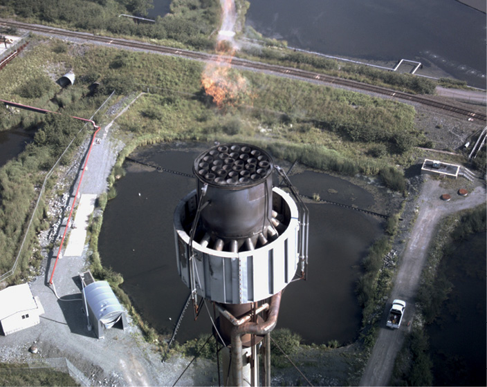
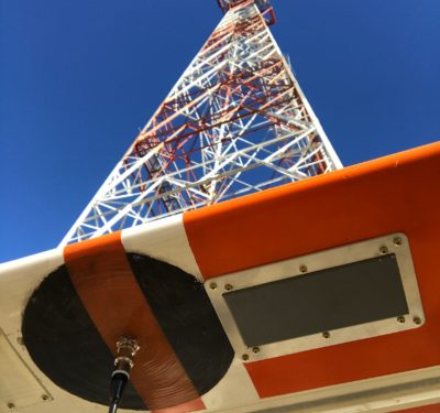
ING Responder flarestack inspection.
Midstream Uses
UAS can also save midstream, or pipeline companies, plenty of time and money, Kroschel said. With UAS, they can survey the pipelines to collect the same data with a quarter of the manpower, for 40 percent less money and in a quarter of the time. It takes eight surveyors to cover about a half mile of pipeline in a day, he said, while a UAS can cover 12-16 miles in the same time, collecting the same data with 3 cm accuracy.
UAI has partnered with ALS Oil & Gas to enhance the company’s pipeline leak detection capabilities. ALS uses fiber optics to immediately spot problems.
“Most of our customers have new installation projects. It’s a little bit more expensive to go into an existing pipeline, dig it up and lay fiber in and then put it back in place,” said Dean Lioliou, director of sales for pipeline and asset integrity monitoring at ALS. “UAI can fly the pipeline and with its sensors identify areas that might have dead vegetation, which is indicative of a leak. It’s a nice complement to what we already do.”
While unmanned aircraft offer great potential value for pipeline inspection, the FAA currently prohibits operators from flying beyond direct line of sight. That limitation makes this application challenging, said Ian Glenn, CEO of ING Robotic Aviation, a Canadian company that flies its Responder UAS in harsh conditions to collect data. There’s plenty of mapping and pipeline inspection work to be done, but that work will still take a while if UAS operators can only inspect a few sections at a time, he said.
“Helicopters have the authority to fly. They’re dangerous and loud and not environmentally friendly, but they have the authority to fly. There’s absolutely no reason for them to fly when any of the drones we have would do a better job, cheaper and faster,” Glenn said. “We need the ability to fly 150 feet or lower down rights of way so we can better collect the data. It’s not a technology challenge; it’s purely an airspace access issue. With UAS we can get better data and rapidly push it out to those who need to make decisions based on that data.”
Even so, ING’s clients have been happy with the results the Responder has produced so far, Glenn said. They’re able to obtain records from the air that show exactly what a right of way looks like, and they’re able to get it in below zero temperatures with winds blowing at 14 knots—all without being exposed to the harsh weather conditions. One project manager installing new pipelines was amazed by the fact he was able to get more data more quickly, without ever having to leave his office—or going through the environmental and safety training required to gain access to the rights of way.
The 3-D map also clearly indicates every marshland and frog pond along their path—essentially everything they need to know about the wildlife in the area so they can avoid disturbing it when putting in pipelines.
“They can share that information with environmental organizations or wildlife centers. It’s a great way to show they are being good corporate citizens,” Glenn said. “I think that alone is invaluable. It’s really important to the communities they’re operating in or through.”
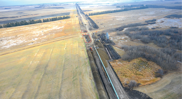
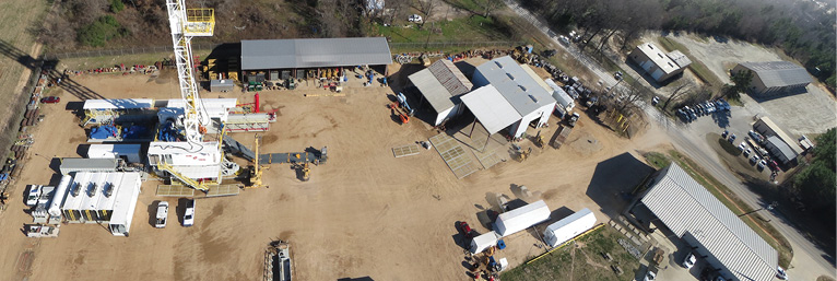
Aerial view from ING’s Responder of pipeline implementation.
Downstream Uses
When it’s time to inspect a flare stack or any other high-value infrastructure at a refinery or chemical plant, the machinery needs to be shut down, said David Proulx, VP product and marketing for Aeryon, a UAS company that provides services to the oil and gas industry.
“Having a flare stack shutdown for manual inspection takes a week or more. It needs to be cooled down, then they have to bring it back up to its operating temperature,” Proulx said. “Then there’s the risk of having somebody visually inspect it. They’re difficult to get at, and using a manned aircraft is risky. If you introduce a small UAS like Aeryon’s SkyRanger, you can keep the stack operating while you do routine maintenance and inspection of the infrastructure. You can perform the maintenance without having to shut down and without losing profits.”
Brian Whiteside, president of VDOS Global, uses the SkyRanger to do flare stack inspections as well as land surveying and monitoring for a variety of oil and gas companies, including Shell and Exxon Mobile, he said. The majority of the downstream work VDOS does is visual inspection, including looking for corrosion, cracks or any other types of damage that indicate problems.
“There’s a lot of need and interest for this technology, and I think it’s going to be integrated into standard procedures going forward,” Whiteside said, “and the biggest reason is safety. Everything they do has risk. This technology allows you to perform tasks without putting humans in dangerous positions. That’s the real value this technology represents.”

UAI
Challenges
When companies like UAI or VDOS talk to oil and gas clients about UAS services, one of the biggest challenges is educating them about the technology and the many ways it can help their business. Most are new to the technology and are uncertain about the FAA regulations—something UAI walks them through.
“Most of them are not even thinking about UAS technology, but once we show them what it can do they’re just blown away. Especially with the cost savings,” Kroschel said. “A lot of them assume we’re talking about large military drones, but you can’t have a big drone like that around a chemical plant. It has to be a VTOL (vertical takeoff and landing) system. You have to get up close and personal, depending on what sensor the UAS is using and what information they need.”
Another challenge is trying to produce data that has legal meaning behind it, Whiteside said. There’s a whole series of steps and levels of standardization, certifications and protocols these companies must follow so they can be used in a legal setting. So they not only have to follow the FAA’s regulations for flying UAS, they also have to meet industry legal and safety standards every time they fly.
And while many people say the UAS technology is there and the industry is just waiting for the FAA regulations to catch up, Whiteside said the technology is still new and needs to be proven.
“It’s up to us to vet the technology, prove how it operates and define areas where there may be more risk and understand those areas very well. With the absence of standardization, that’s difficult to do,” Whiteside said, noting standardization is something VDOS is working on. “The technology has a long way to develop and evolve before it’s where people assume it’s going to be in the near future.”
UAI
Looking Ahead
Even today, oil and gas companies already flying UAS have realized its many benefits. Not only can they perform inspections and other tasks quicker with fewer people, they can perform them more safely and at a fraction of the cost, Millar said. UAS offers better access to difficult-to-reach areas, without the need for scaffolding. They can record the data, take baseline surveys and provide a point cloud to build 3-D models that make it possible to tie all that data together.
“Rather than looking at a spreadsheet of numbers, you can pull the model up and have information superimposed on it,” Millar said. “You get the full picture instead of just isolated data.”
And as more oil and gas companies learn about UAS and become comfortable with the technology, and as regulations become more defined, Whiteside said, UAS will become part of standard operating procedures. UAS technology also gives energy companies access to information they never had before and the opportunity to not only better analyze the data they collect, but to repeatedly collect data for future comparisons and analysis as well.
The technology will continue to improve with batteries lasting longer, sensors getting better, and platforms becoming more standardized. While there are already countless applications, companies will continue to discover more opportunities to use this technology to save time.
“The market is bigger than most people realize,” Whiteside said. “There’s tremendous need for this technology, and it seems like every time we talk with a company about a project, we’re asked to fly five or six more missions than what was considered in the first discussion. The forecast and market is bigger than what people understand, but the technology and laws have to improve. The industry has to get out of the Wild Wild West mindset. But the market is significant, and it’s a very exciting time to be doing what we’re doing.”