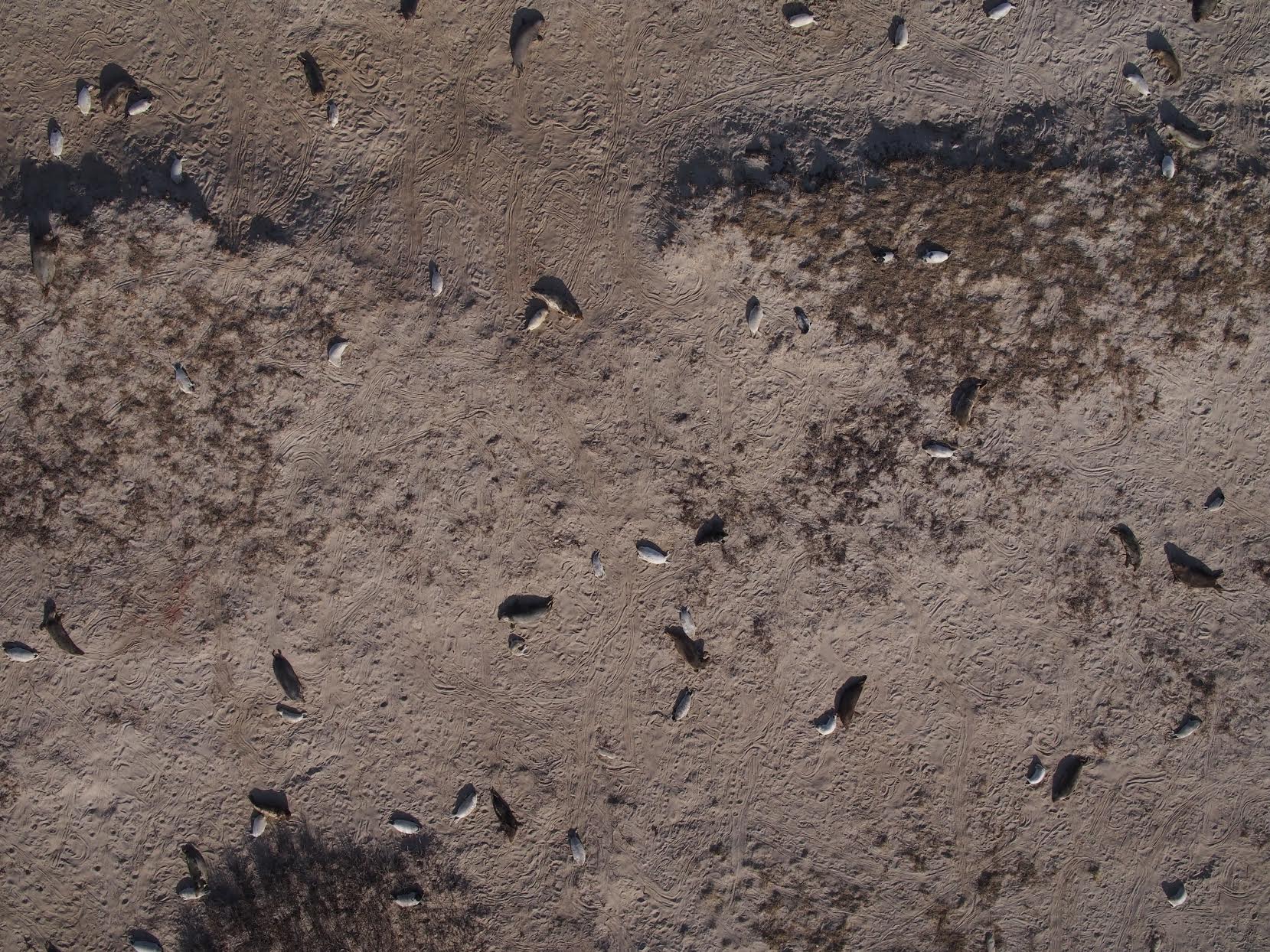
Gray seals and their pups, photographed from an altitude of 200 feet by the NOAA APH-22. Photo credit: Jennifer Johnson, NEFSC/NOAA
Typically, when studying gray seal pup populations, researchers send manned aircraft to gather the aerial imagery they need.
For the first time, researchers at NOAA’s Northeast Fisheries Science Center used different unmanned aerial system platforms to collect information as well. The study was held in January, during the gray seal’s breeding season.
Along with their manned Twin Otter aircraft, the team flew NOAA’s APH-22 hexacopter and the senseFly fixed-wing eBee on Muskeget Island off Nantucket, the largest gray seal breeding and pupping colony in the U.S. Their goal was to not only study the breeding sites and get a better feel for how many gray seals there are in Northeastern waters, but also to compare the UAS platforms to manned aircraft.
“It’s a promising technology for this kind of application,” said Kimberly Murray, coordinator of the seal research program at NOAA’s Northeast Fisheries Science Center laboratory in Woods Hole, Mass. “We could access the island and launch drones to actually do this type of survey for the first time in the Northeast. We wanted to test the technology to compare the different platforms to manned aircraft from an operational, scientific and economic perspective.”
Seals are the perfect candidates for this type of survey, Murray said, and she hopes the UAS images help them get a better grasp on many gray seals are actually in our waters. The aerial images both UAS collected will help document the number of pups on the breeding grounds as well as pup distribution. They also document adult seals, giving researchers data on brand marks or entanglements.
This information will help answer other ecological questions, such as how humans impact the seals and how the seals impact the environment, Murray said.
“During breeding season the seals are on land full time and they don’t move around a lot. They’re kind of just sitting there,” said hexacopter pilot Mike Jech, of NOAA’s Northeast Fisheries Science Center. “The pups are growing and getting ready to go under water, so it makes them amenable to this kind of aerial imagery.”
The platforms
The team tested two UAS platforms that provided different benefits, Murray said. The APH-22 was able to hover, spot sample and look for certain things like entanglements.
It also helped that the APH-22 has been deployed for other NOAA projects, Jech said, so the team already knew how to use it. The UAS features high-quality sensors and is developed by the nearby Aerial Imaging Solutions, located in Connecticut, which Jech noted as other benefits.
Researchers from Duke University were able to easily handle the hand-launched eBee, which continuously fly over the island throughout the day-long study to collect data, said Julian Dale, lead UAS engineer at Duke University’s Unmanned Aircraft System’s group in Beaufort, North Carolina. Dale and his team have completed these types of seal surveys in Canada and brought their experience to this project.
Dale has worked with the eBee quite a bit and said its flight planning software and post-processing ability also represent potential time and cost savings. Another benefit? Its infrared camera picked up heat signatures to detect seals that were difficult to see from the air.
“We typically have no Internet reception in these places,” Dale said. “We download the satellite imagery as a base map, so once we get on site we can very quickly locate the area we want to survey and pre-program the flight path. We can get the eBee in the air within 10 to 15 minutes of being on site and we can monitor the process to make sure we’re achieving the results we need. And the post-processing is a nice, streamlined workflow. There’s very little human input needed to create the orthomosaic.”
Dale has worked on similar studies in Canada and said using UAS to perform these surveys can save a lot of money. A survey Dale and his team completed in Nova Scotia would have cost about $80,000 if manned aircraft were deployed. The cost with UAS? About $10,000.
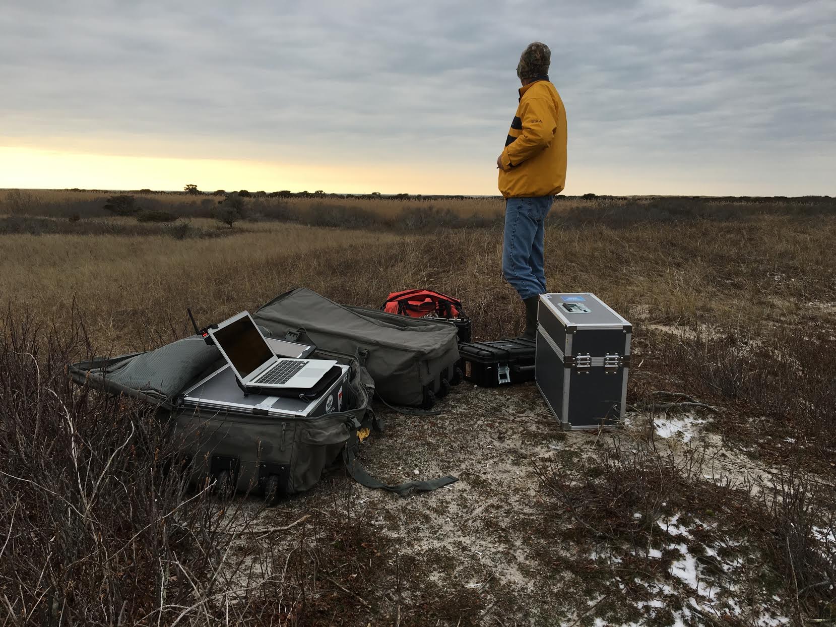
The Duke University UAS equipment. Photo credit: Julian Dale, Duke University
A success
The UAS were only flown during one day of the study, but Pilots Jech and Elizabeth Josephson—as well as the rest of the team—consider the UAS portion of the study a success.
“We haven’t done analysis of comparing the different platforms yet and haven’t analyzed much of the photography yet, but it looked like the hexacopter gave us high quality photographs that will help us look at the stages of the seal pups, entanglements of adults and spacing and distribution of the animals,” said Josephson, NOAA’s Northeast Fisheries Science Center. “We’re trying to learn more about the gray seal abundance here in our area and these images will help us improve our count.”
While Murray sees UAS technology complementing manned technologies in these types of surveys in the future, there are challenges, including weather conditions and accessing islands in difficult-to-reach locations. Manned aircraft also tend to complete surveys faster, she said, but there are things UAS can do that aren’t possible from a manned aircraft.
“They give us greater accessibility to the animals,” Murray said. “The drones we used could get down to fairly low altitudes and not bother the seals. We can get much higher quality images from a drone flying at 200 feet than from a manned aircraft flying at 750 feet. And the infrared was great. We don’t have that technology on our manned aircraft. It helped us find seals that were hidden. There are a lot of things drones are useful for that traditional manned aircraft can’t do.”