As Hurricane Beryl intensifies and moves across the Caribbean, advanced technologies developed by Saildrone, NOAA, and Rutgers University are playing a crucial role in improving hurricane forecasting and understanding.
Hurricane Beryl
Hurricane Beryl is currently impacting Jamaica with hurricane conditions and is expected to approach the Cayman Islands on July 3rd and the Yucatan Peninsula by Thursday July 4th. Residents in these areas are urged to complete preparations to protect life and property as the storm progresses.
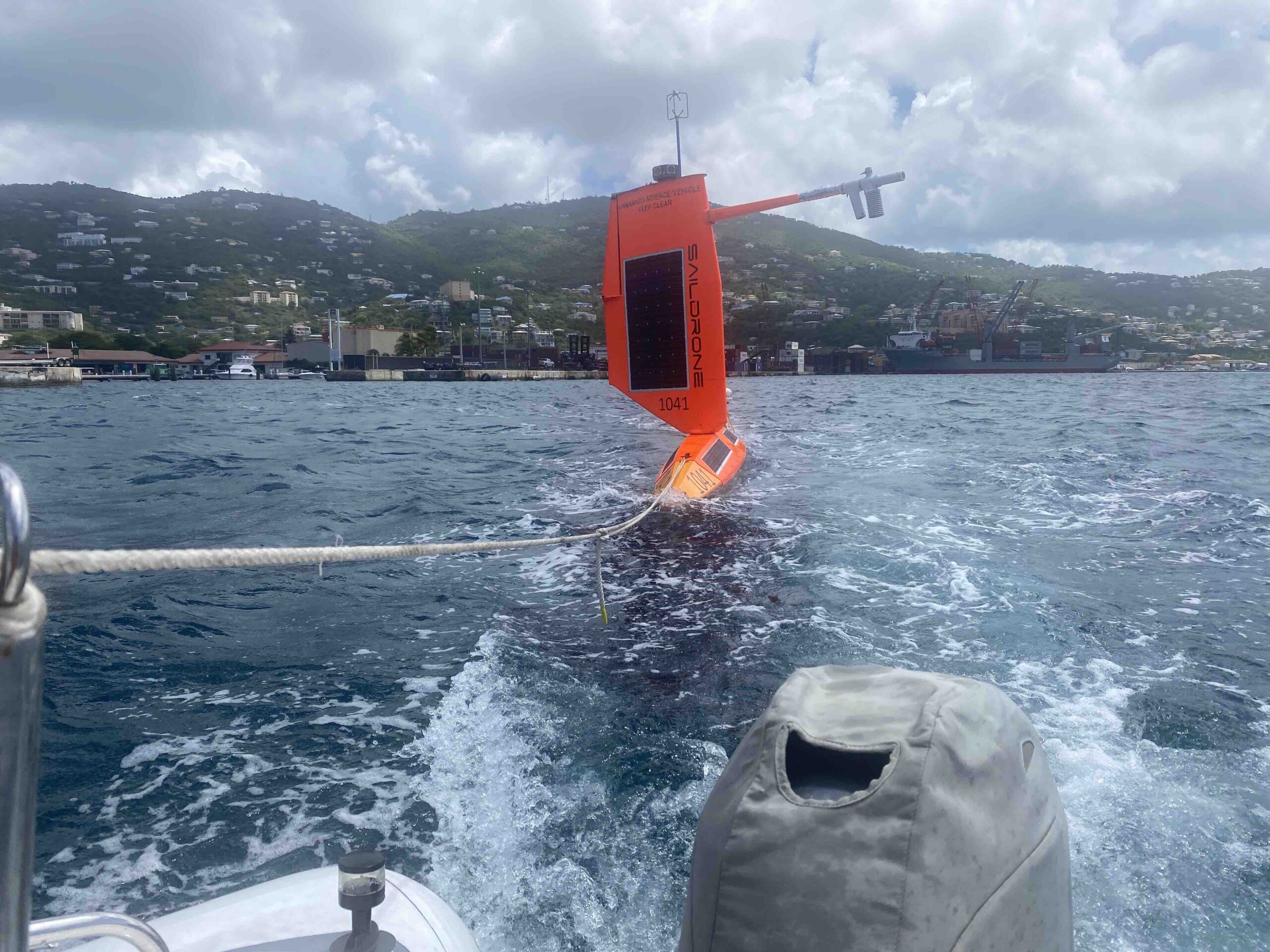
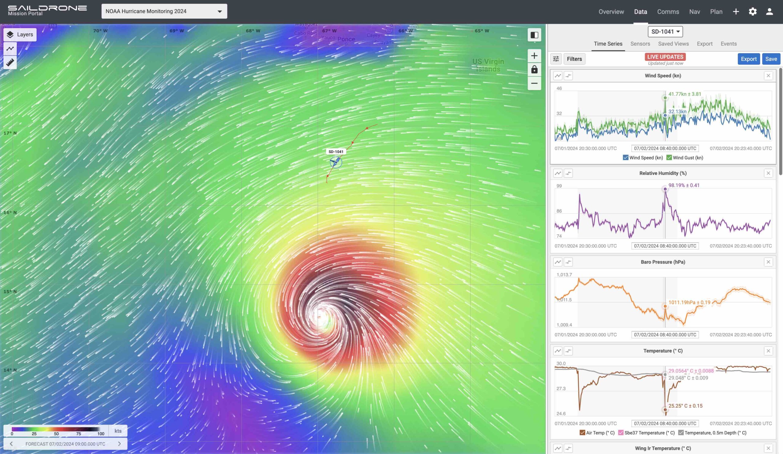
Saildrone, known for its innovative uncrewed surface vehicles (USVs), has teamed up with NOAA to deploy seven hurricane-tracking saildrones in strategic locations. These USVs, equipped with a specialized “hurricane wing” to withstand extreme wind conditions, are gathering real-time data on key atmospheric and oceanic parameters such as wind speeds, wave heights, temperature, pressure, and salinity.
The deployment includes two saildrones in the Gulf of Mexico, launched from St. Petersburg, Florida, and Port Aransas, Texas, and five more in the Atlantic Ocean and Caribbean Sea, launched from Jacksonville, Florida, and the U.S. Virgin Islands. These saildrones provide critical data to improve the understanding and prediction of tropical cyclone intensity changes, particularly rapid intensification—a phenomenon where hurricane wind speeds increase dramatically in a short period.
Rutgers University enhances these efforts by deploying underwater gliders that work in tandem with saildrones. These gliders measure temperature and salinity at various depths, offering a detailed picture of the ocean’s conditions before, during, and after a hurricane. This multi-platform approach is essential for understanding the energy exchanges between the ocean and atmosphere, which are crucial for predicting hurricane intensification.
The collaboration aims to provide high-resolution, coordinated measurements from the ocean surface to the atmosphere, enhancing situational awareness for forecasters and improving the accuracy of hurricane intensity forecasts.
Our researchers flew into Cat5 Hurricane #Beryl w/ @NOAA_HurrHunter to gather data from the air, while a @saildrone and a @RutgersU sea glider gathered data from the ocean, and @NOAASatellites gathered data from space. #collaboration @NOAAResearch pic.twitter.com/gG8P0yM9wo
— NOAA Atlantic Oceanographic and Meteorological Lab (@NOAA_AOML) July 3, 2024
Technological Innovations
- Saildrones: Equipped with a “hurricane wing,” these USVs collect continuous data in harsh storm conditions, providing real-time insights into the physical interactions between the ocean and atmosphere.
- Underwater Gliders: Deployed by Rutgers, these gliders measure subsurface ocean conditions, which are critical for understanding how variations in temperature and salinity affect hurricane strength.
Impact and Future Applications
The data collected by these technologies are invaluable for improving predictive models, ultimately aiding in more effective disaster preparedness and response. The collaboration between Saildrone, NOAA, and Rutgers University represents a significant step forward in the use of uncrewed systems for environmental monitoring.
John Cortinas, Director of NOAA’s Atlantic Oceanographic and Meteorological Laboratory (AOML), highlighted the importance of these real-time observing systems: “Storms that intensify rapidly can cause extensive damage and loss of life. Real-time observing systems are crucial to better understanding the atmospheric and oceanic processes that lead to the formation and intensification of these hurricanes”.