Textron Systems and the larger team developed and delivered actionable imagery of impacted acreage from the Tepee Springs wildfire, such as this overhead geospatial mosaic. Textron Systems
When firefighters arrive at a wildfire, they know the dangers involved. These complex fires create their own weather, and it’s very difficult to predict what direction they might take. The brave people battling these blazes must often make decisions despite considerable uncertainty in situations where the wrong choices could lead to more damage and even death.
The conditions wildfires produce make it nearly impossible to obtain real-time situational awareness, especially at night when it’s too dangerous to fly manned aircraft over the flames. Because their flying time is limited to daylight hours, responders have no idea what happened with the fire overnight, including what direction the fire took and where the hotspots are. This adds to the danger to both the firefighters and the communities in the fire’s path.
The potential for unmanned aerial systems (UAS) to reduce the risks involved in firefighting has inspired many companies and researchers to explore the application. UAS can provide the bird’s-eye view firefighters need to make critical, real-time decisions, while also safely monitoring the fire overnight, said Steven Gitlin, vice president marketing strategy, communications and investor relations for AeroVironment. While still in the early stages, UAS could prove to be an important tool in the fight against wildfires, a tool experts expect to one day become standard during these types of missions.
How it Works
During a wildfire the area around the fire becomes restricted airspace and an air boss coordinates all the flight activity—manned and unmanned, explained Ian Glenn, CEO of ING Robotic Aviation. Piloted craft are often deployed to look for hotspots, drop water on those areas and deliver supplies to crews.
However, many fire agencies can’t afford air support, Gitlin said, and rely on other means, such as lookout towers, to get a view of the fire. UAS can provide a broader aerial view—in real time—without putting observers in danger. To be sure they don’t become a danger themselves, UAS carry transponders so any pilots in the area know where they are at all times.
The data a UAS collects while flying over a fire can be used to create a real-time map of the fire line and hot spots where the fire is especially active, said Dave Kroetsch, president and CEO of Aeryon Labs. This map can be sent back to mission control for planning purposes. The commander then knows exactly where to send resources, so there’s no time wasted dumping water on areas where the fire is less energetic.
“When you’re on the ground, you can’t see what’s going on around you,” Glenn said, noting the use of UAS in wildfires is very similar to their use in military applications. “Delivering real-time tactical information is very important and of great value to the firefighters on the ground and the overall campaign. You get a much better view of where the fire is and isn’t.”
Insitu Rapid Response Team member Joe Cooper does a final flight check. Insitu
Recent Demonstrations
Insitu, Textron and Lockheed Martin all recently worked with the U.S. Department of Interior, or DOI, to demonstrate how UAS could help combat wildfires. The department first started its unmanned aircraft program in 2006, said Mark Bathrick, director of the Office of Aviation Services, and in the last year began to focus on using UAS for wildfire response.
The integrated UAS test plan included a number of demonstrations. The first one, deploying Lockheed’s Martin K-MAX unmanned helicopter, was held last November. The Insitu, Textron and the most recent K-MAX demonstrations were all held this year, marking a significant step forward toward incorporating UAS in wildfire monitoring.
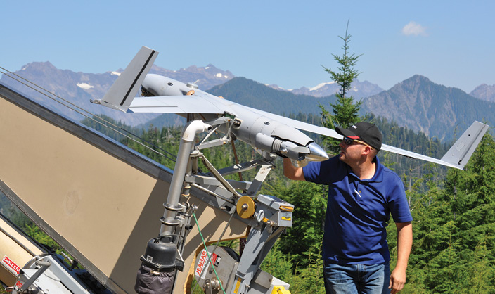
The Insitu Demo
The Insitu ScanEagle flew over a wildfire in Olympic National Park, which was actually a rain forest fire, something Brad Koeckeritz, UAS program manager, DOI Office of Aviation Services, described as a unique event. The aircraft was easily integrated into the existing operation, and flew above all the other tactical traffic during its missions. The sensor onboard located the fire perimeter and mapped the hotspots. This not only showed the crew how effective the helicopter’s water drops were, but also exactly where they needed to focus their efforts to battle the blaze.
The ScanEagle also flew at night, said Charlton Evans, Insitu Commercial and Civil UAS Program Manager, a task that’s just too dangerous for manned aircraft because of the smoke and weather patterns a fire creates. Night flights can give firefighters vital information to start the next day, and a much better idea of where a fire is headed.
The ScanEagle’s infrared sensors also helped the team see through the smoke, Evans said.
“We worked with the helicopter pilots doing the water drops on the fire, and they were ecstatic with how well we could provide them with real time feedback of where they needed to put the water, as well as what the result was after they dropped the water,” Evans said. “The pilots can’t see what’s going on under the helicopter when they drop the water, so they don’t know if they hit the right spot or not. The ScanEagle allowed the pilots to assess the results of their drop in real time, giving them feedback immediately, so they know exactly where to put the water the next time.”
The team also wanted to see if they could use the imagery collected to create maps, supplementing their current mapping strategy, Koeckeritz said. The biggest challenge this presented was determining where to position the sensor to capture the right images.
“Mapping is one of the areas that still needs work,” Koeckeritz said. “But the lessons learned at that fire show us what needs to be done for us to rapidly take data from an aircraft and turn that data into a useable map for firefighters on the ground.”
UC researchers, in collaboration with the West Virginia Division of Forestry, are building a UAS prototype equipped with vision and infrared cameras. Manish Kumar, U. of Cincinnati
The Textron Systems Demo
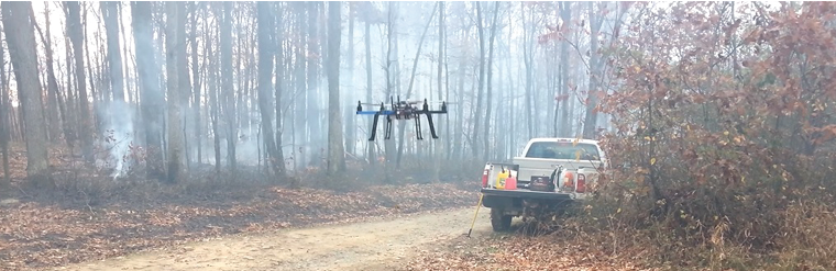
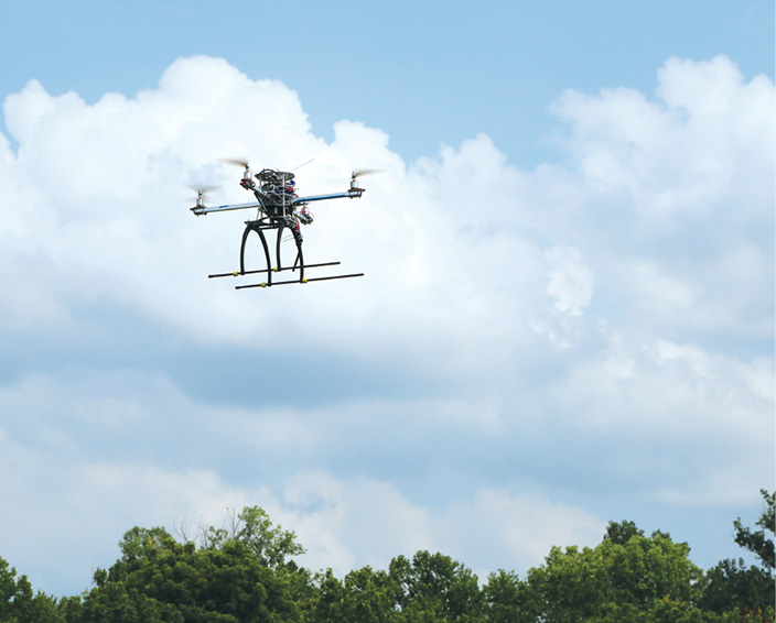
The team from Textron Systems’ Unmanned Systems division had a similar experience, flying the Aerosonde UAS over a wildfire in Tepee Springs.
The fire covered 97,000 acres when they arrived, and 600 people were onsite battling the blaze, including smokejumpers who live in the forest for months at a time and drop from planes to fight these fires, said Chris Ellsworth, program manager for Commercial Unmanned Aircraft Systems. The fire was in a remote area, with a two-hour drive from the command post to where the team operated. The nearest town was 1.5 hours away, and that meant the team lived in tents the two weeks they were there.
It was cold and staying in touch was challenging, but thanks to the satellite communication equipment the team brought with them, they were able to provide real-time information to the responders.
“They needed to know where the hotspots in the fire were yesterday and where they might be tomorrow, and use that information to direct their assets,” Ellsworth said. “We located the areas burning and were able to generate very rapid reports and email those reports to incident command to show them a fresh view of where the hotspots were located. Typically a person in a manned aircraft gets on the radio to describe where the hotspots are, or flies the perimeter and develops a report delivered 12 to 18 hours later. We delivered that information in half an hour.”
During the missions, the Aerosonde flew above the manned aircraft and offered an umbrella view of what was happening below, said Sean Baity, chief engineer for civil and commercial programs. Even from that range the UAS could detect where the fire was most intense, not only providing the crew with real-time information, but better, more accurate information.
Every morning the team came together to plan out the day’s execution plan, and review what happened in the evening hours, Ellsworth said.
“A wildfire is a living, breathing, dynamic environment, and aviation missions are very dangerous,” said David Phillips, vice president of small and medium endurance unmanned aircraft systems. “You can imagine smokejumpers in the wilderness without any connectivity overnight. The wind shifts and they’re unaware the direction of the fire has changed. UAS provides real-time awareness of what’s going on metrologically and on the ground where the thermal environment is changing rapidly.”
Insitu Rapid Response Team member Bronson Ignacio prepares ScanEagle for flight. Insitu
The K-MAX Demo
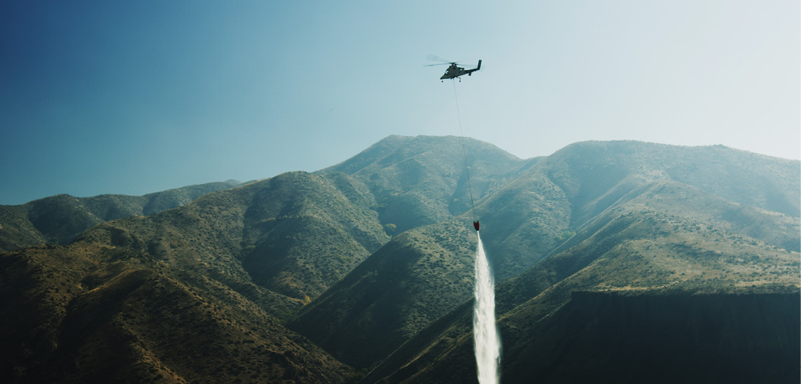
The most recent DOI demo, held in October, involved the K-MAX, an optionally-manned, power-lift helicopter that Lockheed Martin and Kaman Aerospace Corporation transformed into a UAS capable of autonomous or remote controlled operations. They flew 11 missions during a fire in Boise, Idaho, delivering water and cargo to various locations, Koeckeritz said, missions similar to what the K-MAX performed during military operations.
Using the K-MAX as an unmanned aircraft provides many benefits during a wildfire, Bathrick said. When manned the helicopter can only fly for eight hours, but if it’s unmanned, it can stay in the air for up to 24 hours, tripling the amount of support the aircraft can provide. It can also fly at night and during the early morning hours when manned aircraft must stay grounded.
“The temperature drops, the winds die down and the humidity levels tend to rise so the fire behavior becomes less severe at night, making it more vulnerable to a direct suppression effort,” Bathrick said, noting the Interior Department already has several K-MAX optionally piloted helicopters on contract. “The K-MAX not only triples the amount of time we can fly, but it allows us to attack the fire when it’s most vulnerable, rather than during the heat of the day.”
They plan to use the helicopters they already have on contract for wildfire missions, Bathrick said, flying them with a pilot during the day when it’s clear and then transitioning to unmanned during the night and early morning hours. And because the aircraft can be manned, they can easily fly to the next fire without needing a Certificate of Authorization from the FAA, giving them more flexibility.
Koeckeritz and Bathrick are happy with the results of these demonstrations, and will continue to work with the FAA and manufacturers to determine how to best use UAS as a tool during wildfires. If they continue to see positive results, Bathrick expects UAS will someday become a standard tool firefighters can use to combat complex, dangerous forest fires.
Lockheed Martin K-Max. Lockheed Martin
Building a Prototype to Fight Wildfires
UAS manufacturers aren’t the only ones determined to incorporate UAS into wildfire response. Researchers—including Associate Professor of Mechanical Engineering Manish Kumar and Professor of Aerospace Engineering Kelly Cohen from the University of Cincinnati—are also looking into making this application work.
They started their research, known as the the PFI:AIR-TT: Situational Awareness during Fire and Emergency (SAFE) project, about five years ago. The team, working closely with the West Virginia Division of Forestry and other agencies, has developed a working prototype of a UAS designed specifically for use during wildfires.
Over the next few months, the team will vigorously test the prototype during outdoor flight tests at the airport in Wilmington, Ohio, and modify algorithms for outdoors and real-world conditions with communication delay and loss, Kumar said. In the Spring, they plan to test the UAS in the WVU Research Forest during a real, but controlled, wildfire in collaboration with the West Virginia Division of Forestry.
The prototype can plan its path autonomously, Kumar said. The operator can locate an area on the map and the UAS will plan and follow a path to that area, providing real-time video to the ground station. The videos are processed to obtain hot spot locations, which will then be transformed into Google Maps in real time.
“Not having real-time information is the main cause of catastrophes in these situations,” Cohen said. “They need to know where the fire is and how it’s advancing, and use that information to allocate resources to combat the fire. We can take the information from the UAS to locate the fire, and add the topology from Google Earth and the weather conditions, and then come up with a predictive model that shows how the fire will advance from now on given these conditions.”
Rodger Ozburn, regional fire specialist for the West Virginia Division of Forestry, has been part of the project since the beginning, giving the team feedback about what firefighters need most in a UAS, and insight into some of the challenges that might come up while flying these missions. They need the UAS to be easy to use and rapidly deployable, he said. They’d like the ability to get it in the air in 10 minutes or less, and to carry it in a box that fits easily in the back of a vehicle. It also needs to have an infrared/thermal camera to not only find hotspots, but also help locate firefighters on the ground if they ever lose communication.
Ozburn is excited about the idea of employing UAS in this type of application and said that after the initial purchase and training, UAS can help departments like his save time and money. Gaining access to manned helicopters is expensive, not to mention the time wasted traveling to the airport to get in a helicopter or a fixed-wing, and then flying back to the fire location. Most UAS don’t need a runway for launch or recovery, and can be deployed even in remote areas.
“It’s just so much better economically than putting a helicopter in the air for certain missions,” Ozburn said. “Plus the fact that you have a UAS capturing footage for people on the ground. It’s much better than having three or four people in an aircraft that could drop at any minute.”
U. of Cincinnati
The Challenges
One of the biggest challenges Ozburn sees to incorporating UAS into wildfire monitoring is public perception. Many people view UAS or drones as a negative, and recent news about hobbyists interfering with wildfire response over the summer didn’t help.
That’s why it’s important for the industry to not only raise public awareness about the benefits of UAS, but to also make sure the public understands the risks of flying hobby drones in the restricted airspace around a wildfire.
“There are members of the public who might want to operate one of these systems to get a better view of a forest fire,” Kroetsch of Aeryon Labs said. “We need to raise awareness that while that’s interesting for them, they could be inhibiting the safety of the operation.”
Another challenge smaller agencies like the West Virginia Division of Forestry face is finding the money to invest in UAS, Ozburn said. While these systems should save money over time, it can still be difficult to find the funds to purchase a system—and some agencies might be leery of spending money on such a new technology.
And there’s also the fact that firefighters have battled these blazes the same way for years, and UAS represents a paradigm shift in the way they operate, Cohen said. Implementing UAS means they have to change the way they conduct their operations. It’s a cultural change that some might be resistant to at first, though once they see what the technology can do, most are excited about learning to use this potentially life-saving tool.
It will still take time to integrate this new solution into their policies and procedures, which is why companies like AeroVironment are working with organizations and agencies to educate them about the benefits of UAS and how manufacturers can support them, Gitlin said. This is an important step, because figuring out how to best incorporate UAS into these complex operations is key to making this application a reality.
The Future
At some point, UAS will be a standard tool for wildfire missions, Gitlin said. He expects UAS to become an integral part of the way firefighters address these blazes, quickly providing them with the situational awareness they need without putting anyone in harm’s way.
Research and demonstrations like those performed over the last year will prepare firefighters for that day, helping them determine how to best integrate UAS into their operations. This is still a relatively new application for UAS, and Insitu’s Evans expects to see a lot more demonstrations during next year’s fire season. Through these demonstrations manufacturers and fire agencies will not only learn how to best overcome the various challenges they face, but those with doubts will see what UAS can do to improve operations—and ultimately save lives.
“The last thing we want to happen is to put a tool on the fire line that doesn’t support the ground firefighters. It’s a matter of demonstrating the capability,” Koeckeritz said. “We know the mission requirements, and once we show these types of aircraft can meet those mission requirements, firefighters will be open to integrating them into their operations because it’s the right thing to do, and it makes sense for the mission.”