Just-Released Quantix Recon Leverages Survey Assets for the Military Sphere
Attention toward technology often favors the big, shiny and super-equipped. This may be especially true for military UAS, where airline-sized RQ-4 Global Hawks, heavily-armed Reapers and other frontline fliers attract the spotlight.
But say you have an intel team operating in remote areas when you need high resolution, up-to-date maps and don’t have an internet connection? Or when that team is working independent of a large base and needs to conduct bomb damage assessment without revealing its position? And what if the operators don’t have all that much UAS experience in the first place?
For those missions, ease of use, cost-effectiveness, stealthiness and the ability to generate on-demand maps with current situational awareness may be solutions the big birds aren’t cut out for. And to make them happen, new concepts can harness knowledge acquired from both military and commercial experience.
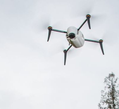
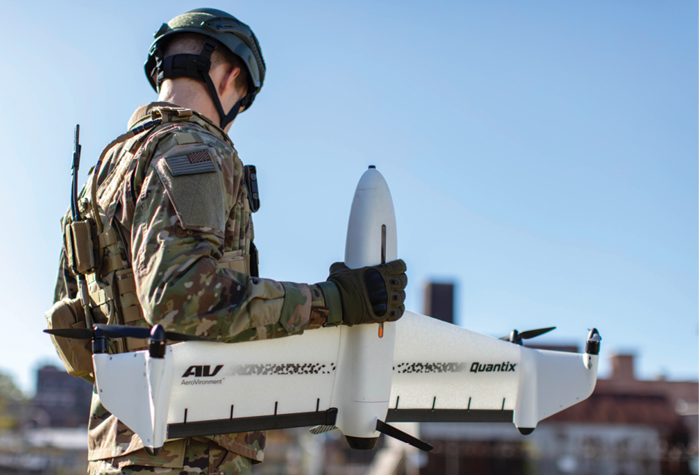
Such is the case with the just-announced Quantix Recon, a low-to-mid-group-one class UAS tail-sitter that AeroVironment is positioning as “a cost-effective, simple-to-use VTOL mapping solution for defense applications.” The Recon is something of the Miata of military drones: easy to operate, satisfying, affordable and capable without packing in every possible option. You might even call it “elegant.”
ENTER THE RECON
AeroVironment Product Line Manager for Tactical UAS Brian Young explained how this new Recon system came to be. “We regularly meet with our military customers about a number of different efforts,” Young said about the Simi Valley, California-based company’s focus on customer needs. He referenced AeroVironment production of the long-endurance Puma LE and the hand-launched, fixed-wing Raven, which itself offers Swiss Army Knife-style versatility through its multiple features.
Quantix Recon was gestated by the military’s desire for ease of use. “When we started to hear about their latest requirements for our Raven/Puma products, a lot of them made sense in the Quantix world,” Young continued. He was referring to AeroVironment’s commercial information Quantix hybrids, which employ automated VTOL flight and software specific to farm management. But a new need came into focus as the services’ comments suggested there was a space for a model focused on specific military needs. “When we heard things like, ‘We have to have things that require less training,’ there are a lot of features on Puma and Raven that go really deep but take a little bit longer in terms of training. In some cases, that makes a lot of sense; in other cases, the military just wants the easiest thing to use, where they don’t have to train every enlisted soldier to operate.” Recon doesn’t have a gimballed camera and takes snapshots rather than video, but it meets the military’s quick-and-simple mandate. “You just hand them a piece of equipment out of the box that’s intuitive to use. Obviously, the feature set must be a little bit less, but the ease of use is quite a bit simpler.
“That’s one of the things we heard from every service, domestically and internationally—that ease of use is really critical. Quantix Recon matches that.”
Being ready to fly just 5 minutes out of the box is a military plus, as are altitude presets for variable coverage areas or detail, no camera settings to adjust and hands-free data collection. But what crucial capability could be added without piling on complexity? “The ability to get really detailed imagery and maps” turned out to be vital. Taking multiple videos via other systems and manually trying to configure them with software to create a map can “get a little bit cumbersome,” Young continued. “The Quantix Recon is really built from the ground up for ease of image collection. And that is a specific application that the military has interest in.”
AeroVironment wasn’t starting from scratch: rather, it set out to leverage its experience on both sides of the military-commercial continuum. “Military is the primary business,” Young said. “But any time we can borrow the latest technology or user experience from other areas of the company and outside the company, we like to do that. This is one of those examples. We developed for several years, the commercial version of Quantix”—again, that’s AeroVironment’s automated VTOL crop scouter–“and since we play in both markets, we can take the best of both worlds. In some cases it pays to take the military stuff and put that into the commercial world, and then the opposite can be true.
“When we thought of all this, what existed were the standard Quantix products for the agricultural market, primarily. Simultaneously, we thought of the Mapper product on the commercial market and the Recon product, which is more focused on the military.” Both would provide fully automated operation and high-resolution mapping imagery on an operating tablet, internet-free and infield, and synergies would enable getting to market more quickly. “The software changes were easier to do on the Mapper side; it took a little bit longer for the [military] software.”
RECON TAKES THE FIELD
The military had been looking at VTOL for its ease of takeoff and landing while maintaining at least some fixed-wing range, speed and efficiency. “That’s one of the things Quantix does really well, and it came out of ease of use,” Young continued. “You can fly faster, have better endurance and you have a little bit better payload capacity when you get into that fixed-wing transition flight.”
Yet another key requirement—rapid, covert reconnaissance—was being increasingly required by customers. And so, Recon—which doesn’t have to worry about BVLOS (beyond visual line of sight)/Part 107 issues—can have its transmitters deactivated after launch with a simple right slide of a soft switch to fly without a detectable RF signature. That extends radio-silent range from 2 to 20 kilometers out and back, allowing for up to four times the coverage of many quadcopters. It also makes Recon nearly undetectable at 360 AGL, reinforcing its ability to gather actionable intelligence undetected.
“The combination of ease and range was great,” Young said.
The integrated sensor system is similar to that of Mapper’s: 18 megapixel cameras for true color and multispectral, plus an ILS solar sensor to self-calibrate images—all optimized to Recon’s speed and height parameters. Recon’s flights then provide current, actionable maps in a GeoTIFF format, which can be used with many commercially available data exploitation tools.
“The ability to have up-to-date maps in areas where you might not have them—it’s so very important to do that,” Young explained. “We can put the world’s maps on that SD card. Of course, those maps might be months or even years old. So you need an up-to-the-minute map to get the latest data possible, whether you fly for 45 minutes or do a shorter mission.”
Use cases revolve around three mission-planning modes. To observe a larger “Area,” the user draws a polygon on an 8-inch Android tablet and the software determines the most efficient way to fly it. “Waypoint” mode creates automated missions by inputting specific GPS or GLONASS latitudes and longitudes, or by tapping points for added picture-taking. “Linear/corridor” automates missions around roads, railways and other straight-line objectives by defining a poly-line and then flying Recon to take pictures down a straight line for up to those 20 kilometers, out and back.
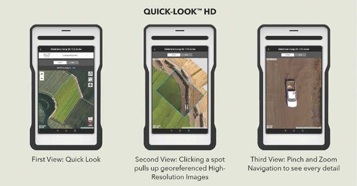
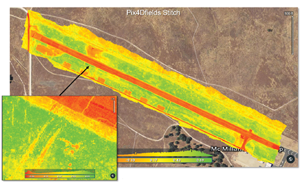
Once the Recon lands, another triad of options becomes available. With the Flight SD Card placed into the tablet, the Quick-Look™ HD App uses wireless to immediately download georeferenced True Color and NDVI (normalized difference vegetation index) images without needing internet connectivity. Clicking on particular spots then provides more granular displays, while “pinch and zoom navigation” is used for high-resolution scrutiny. Those images are stored as GeoTIFFs that are compatible with tools such as Google Earth—AeroVironment employs commercially available software such as Pix4D, which, when subsequently used on a more powerful laptop, can build detailed georeferenced maps down to sub-inch GSD (ground sample distance). The tools also can provide maps compatible for mission planning inside AeroVironment’s Puma or Raven counterparts.
CHALLENGES AND ACHIEVEMENTS
 No vehicle can be all things to all customers. Payloads aren’t swappable for the Recon, but the system is capable as is without risking inexperienced operators mucking it up in the field. Quadcopters can hover, but Recon can cover more area at higher speed than quads of the same size and class. Recon does not have terrain follow per se, but the DTED (digital terrain elevation data) Level 2 data on the SD card digitally renders landform, slope, elevation and/or terrain roughness over a 30-meter area, warning users if a mission at a certain altitude doesn’t conform (installing another system would put Recon beyond its weight, size and power parameters, as well as its price point). That said, AeroVironment has retrofitted to meet customer needs in the past, and, Young said, could do the same with Recon.
Meanwhile, Quantix Recon is debuting its key benefits to the military—ease of use, in-field covertness, quick maps and cost-effectiveness—while avoiding “scope creep.” And, Young suggested, Recon rests on another, more ineffable, factor. “Every feature that a customer tells us sounds great: size, weight, power. You can end up with features that put you in a pretty tight design space.” Rather, he said, Quantix Recon, excels at a singular quality that perhaps reinforces the Miata metaphor—elegance.
“In terms of this market, I always look for elegant products,” he explained. “You talk about features in terms of what the customer might need, but at the end, is the product elegant or not? That’s somewhat subjective, but I really think this has got that level of elegance. It just fits in the right spot at the right time. All around, the product, the way it came about, addresses our customers’ needs, to address a problem that is in very high demand from the military side of our business.”


