Unmanned platforms are capturing critical hurricane data forecasters haven’t had access to before, while drones are also being deployed to map coasts and detect erosion caused by these intense storms and our changing climate.
In recent years, hurricanes have grown in intensity while erosion has become a bigger problem for our coastlines. These growing environmental challenges can have far-reaching impacts on human lives and economies—making it critical to learn how to better predict storms and protect shrinking coastlines.
Drones are being deployed for both use cases, gathering hurricane data forecasters didn’t have access to before and quickly mapping large areas of beaches, before and after these storms hit and any time engineers want to collect data in between.
The National Oceanic and Atmospheric Administration (NOAA) is leveraging drones and other uncrewed systems, including USVs from Saildrone, to get closer to dangerous hurricanes. Satellites and crewed aircraft still provide valuable information, but they can’t monitor what’s happening at the bottom level of the storm or the air-sea interaction. Uncrewed systems can, and NOAA is now deploying three: air launched uncrewed systems, uncrewed surface vessels and buoyancy gliders.
“All of these tell us about air-sea interaction and how much heat and energy the hurricane will get from the ocean, which is what drives a lot of forecasts, especially intensity forecasts,” said Captain Bill Mowitt, director of NOAA’s Uncrewed Systems (UxS) Operations Center. “NOAA has made significant improvement in forecasting where a storm is going to go, but we still need work on intensity forecasts, especially rapid intensification. Uncrewed systems are starting to provide us with that data and an understanding of how these storms work.”
Hurricanes like the recent Helene and Milton can “ravage a beach,” said Gwyn Nelson, Wales Coastal Monitoring Centre (WCMC) program manager, and “understanding that change is important to us.” Baseline drone surveys are critical to that understanding, providing a historical record of the coastline and documenting changes over time.
About 40% of the world’s population live within 100 km of a beach, said Karen Joyce, Associate Professor in Remote Sensing at James Cook University in Australia, but it’s not just locals who rely on the coastlines. There’s a “huge amount of other important activities that go on in a coastal environment as well, making this monitoring critical.
“We have ports, our major cities around the world are on coasts,” said Joyce, who is also co-founder and product lead for drone data management company GeoNadir and co-founder of She Maps. “We often have high value infrastructure on coastlines, houses, bridges, roads, and people value these areas for recreation as well. Our global population relies heavily on our coastlines, so it’s important to understand what the ebbs and flows are. That helps us plan for the future.”
HURRICANE MONITORING
The Background
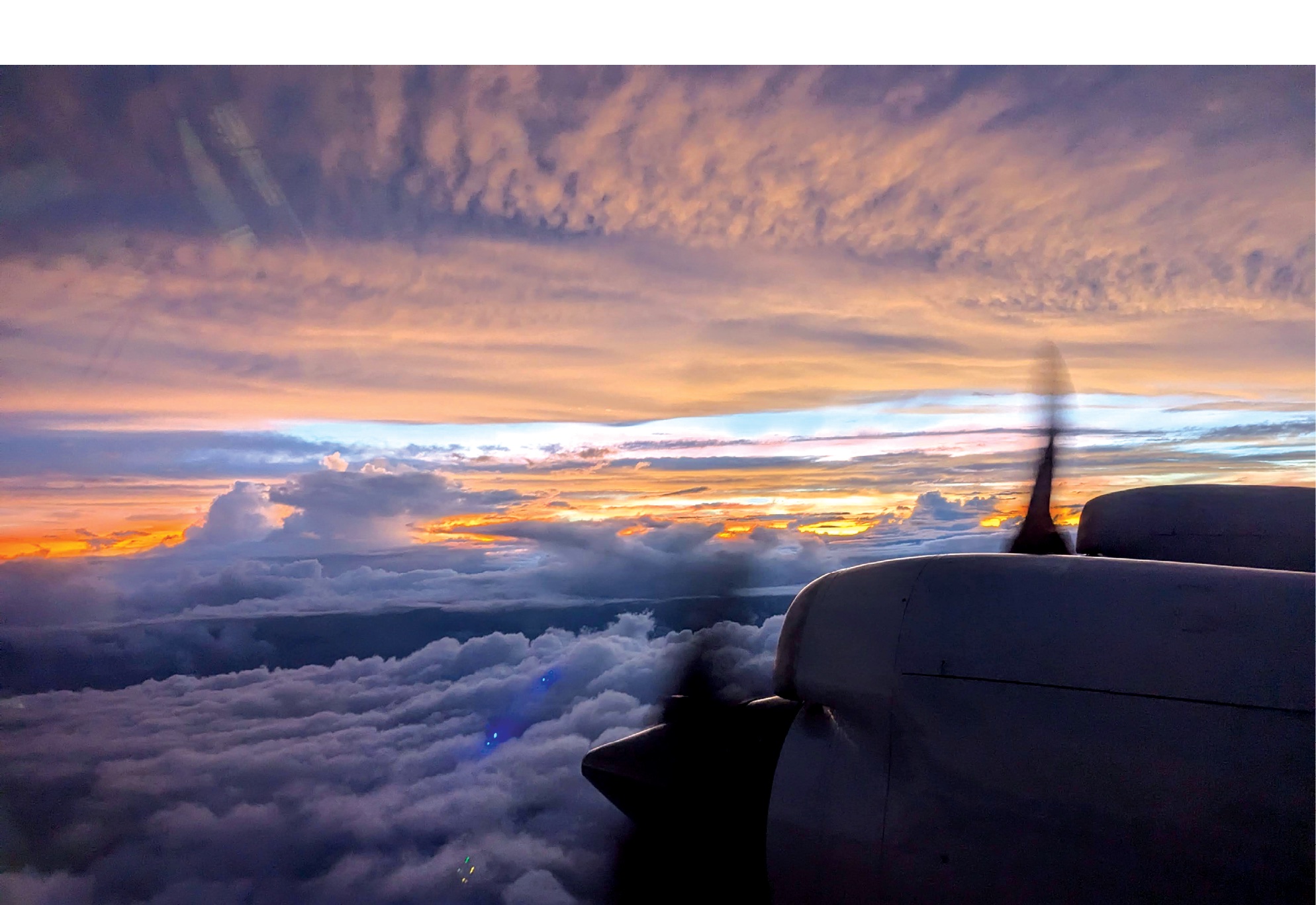
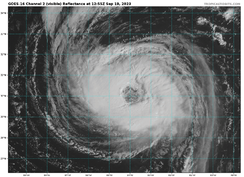
Launching drones to study hurricanes isn’t new for NOAA; the agency sent the first Raytheon Coyote directly inside a hurricane in 2014, according to past Inside Unmanned Systems reporting. The Coyotes, also deployed in 2017 and 2018, were released from a NOAA P-3 Orion “Hurricane Hunter” four-engine turboprop recon aircraft. These drones collected valuable measurements, including temperature, pressure, moisture, wind speed, wind direction and sea surface temperature. They also captured the first direct readings of turbulence in a hurricane eyewall at altitudes below 150 meters.
While the Coyotes could gather the necessary data, their capabilities were limited. For example, they had to stay close to the P-3 or comms would be lost. NOAA decided to look to the Small Business Innovation Research Program (SBIR) to find a replacement. The Altius 600 from Anduril and the SO from Black Swift Technologies are among those funded and tested. The Altius 600 collected data in 2022 and 2023, while Black Swift, after winning the final research and development contract from NOAA, took over for the 2024 hurricane season.
The SO drones completed 19 flights in four different storms in 2024, from tropical events to powerful Category 5 hurricanes, Black Swift Technologies CEO and Co-Founder Jack Elston said. The longest flight was 105 minutes in a storm, a record for the platform, with the OS gathering more than 20 hours of high-resolution data in an area they’ve never been able to get information from before.
Because of the operations center Mowitt leads, founded in 2020, NOAA now has more centralized funding, allowing them to accelerate testing. In the past, they only flew a few times a year, then might skip a few years before flying again.
“We’re starting to get enough data that the folks at the National Hurricane Center have become familiar with it and are starting to think about it,” Mowitt said. “When making forecasts, our scientists can look at the data and say this is improving our understanding of the physics of the storm. We’re getting to the point where we can start to assess the impact of the systems.”
Impactful Data
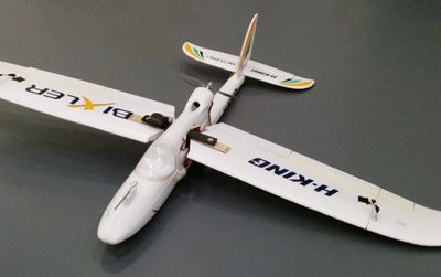
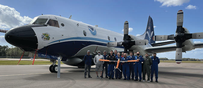
Black Swift began developing the SO in 2020 after receiving a SBIR research grant from NOAA in 2018, Elston said, designing a platform that fits into a four inch tube on the P-3. The SO, which weighs about 3 pounds, is dropped out of a small hole in the P-3 to collect data from the lower part of the storm, where manned aircraft can’t go.
“If you think about it, the low level winds, the bottom of the storm, that’s the part of the storm we care about. That’s where we are. That’s where all our stuff is,” Mowitt said. “But it’s not safe to fly there with crewed aircraft. Launching UAS can provide high resolution maps of low level winds data we couldn’t get any other way. And it’s the data that impacts our communities the most and tells us most about the storm structure.”
The small drone deploys a parachute once launched, Elston said, that orients it vertically. It drops off its protective tube, folds out its wings and begins to detect the wind and environment around it before losing the parachute and conducting its mission. Sophisticated algorithms enable the drone to determine where it’s located and to find the max winds in that elusive interface.
“They want us close to the sea surface because the ocean gives the most energy to the storm,” Elston said. “They usually use dropsonde tubes with parachutes that can estimate winds, but they’re only able to get one or two data points. The SO can drop down just above the ocean and provide thousands of data points in a single flight.”
The aircraft can communicate more than 170 nautical miles from the P-3, Elston said, so the manned aircraft doesn’t have to “babysit” the UAS; it completes its mission while the SO streams data back to it. That data is then converted into the proper format and sent to the National Weather Service in near real time, where it’s put into hurricane models.
“The challenge has been not so much getting them to survive in the storm, but getting the endurance and range of communications has been key,” Mowitt said. “In some cases our crewed aircraft need to get out of there, so we need to be able to communicate from far away with this really small UAS package. We did a lot of work with Anduril and Black Swift on radios and frequency and figuring out the right mix to get the comms range out more than 100 nautical miles so our aircraft can go do something else.”
The SO carries various weather instruments, including the company’s custom 3D wind measurement tool.
“There’s nothing incredibly exotic about the payloads; they’re just getting basic information about temperature, humidity, wind speeds, salinity. What’s exotic is getting them into the storm environment,” Mowitt said. “That’s the hardest part.”
Last year, the SO was installed on one P-3 and never deployed at the same time; the team had to ensure the SO didn’t interfere with the P-3’s operations. SOs were placed on both this year for the first operational tests, with flights offset by 12 hours so data could perform model runs four times a day, Elston said.
Black Swift has another two years to finalize the system and add functionality, such as being able to sample different parts of the storm at the same time. By 2027, Black Swift should have a product ready for NOAA to use regularly.
“They base all models on data from around the storm,” Elston said. “As long as several days out they’re trying to give appropriate warning, but that’s incredibly tough. If you look at predictions once you get one or two days out, that can be pretty accurate, but even then you can miss. And there’s an economic impact to evacuating a place that doesn’t need to be evacuated or failing to evacuate early enough. Satellite measurements can only give them so much of the needed measurements from inside the storm. This is another level of being able to gather that information.”
Systems at Sea
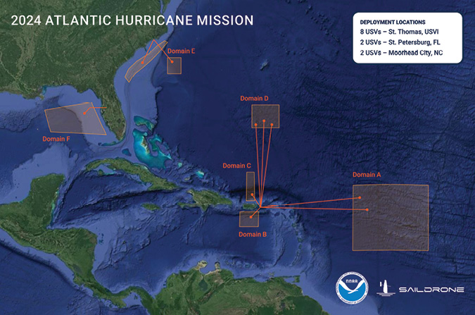
NOAA is also deploying USVs to improve hurricane monitoring and has worked with Saildrone since 2015.
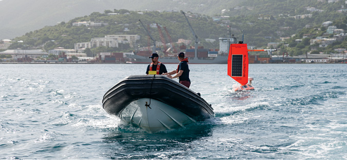
Saildrone collaborated with NOAA to identify the appropriate sensor suite to deploy on the USVs and ensure the data quality delivered matched their requirements, said Ross Branson, Saildrone’s director of government relations for NOAA programs. The team also worked together to develop a wing that is shorter and more robust than what’s found on other Saildrones and able to withstand winds of more than 100 mph.
“The fundamental challenge was developing a boat that can stay upright or become upright if knocked down and maneuver in a storm environment,” Mowitt said. “They had to be rugged and have different sails, different wings than normal Saildrones, to have a lower center of gravity that enables them to be more stable in a storm environment.”
The USV created, first deployed in 2021, is wind and solar powered and collects various datasets, including wind speed, wind direction, ocean surface temperature and barometric pressure—all at the air-sea interface, Branson said.
Saildrones can intercept hurricanes to collect datasets that better inform forecast models and answer the question: How do these systems rapidly intensify? There are now 12 Saildrone USVs deployed in the Atlantic Ocean, the Caribbean and the Gulf of Mexico. When there’s a storm, the closest Saildrones are routed to it.
Saildrone USVs provide near real time data from the eye of the storm via the company’s mission portal, Branson said, giving them direct communication with NOAA.
“That’s pivotal for hurricane projects,” Branson said. “Storms pop up and can be fast moving and sudden, so we are in direct communication when storms develop on how to get the drone in the right placement, and when we get the data via our mission portal, we analyze it in near real time, with some datasets offloaded post mission.”
Saildrones provide a cost effective, safe way for NOAA to access data from the air-sea interface that they never had access to before, Branson said, and have become a “force multiplier.”
Putting it All Together
NOAA deploys other assets to monitor hurricanes from the water, including underwater, long-endurance buoyancy gliders that record ocean heat content and salinity that fuel rapid intensification. The gliders were developed in partnership with the U.S. Navy and universities. Saildrone closely coordinates with NOAA to ensure the USVs are located near these assets to provide a full atmospheric column worth of data, Branson said.
The buoyancy gliders have been used for a while, Mowitt said, helping to “improve intensity forecasts by up to 50%.”
“Having the UAS, the Saildrones and gliders at the same place at the same time as the storm gives us this incredible picture,” Mowitt said. “Those coordinated measurements will help scientists see storms from below the surface, at the surface and at low levels, unlocking a lot of understanding about hurricane physics.”
COASTAL EROSION
Monitoring Coastlines
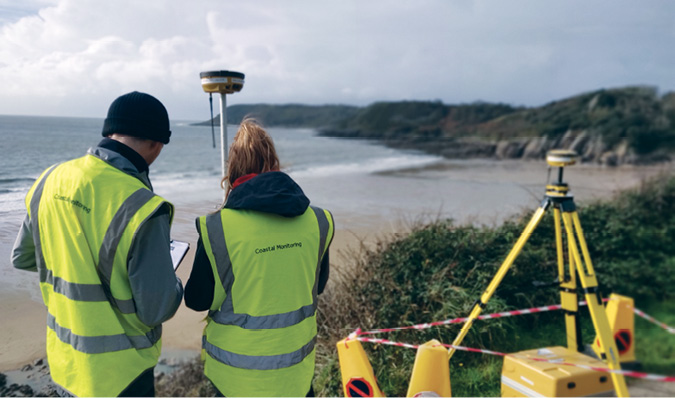
The WCMC, funded by the Welsh Government, was established in 2019 to monitor coastlines and keep the Flood and Coastal Erosion Risk Management (FCERM) updated on changes. At first, they used GNSS receivers and took standard spot measurements on local beaches to collect data. They started looking into drones as a more efficient solution. With the ability to fly LiDAR via these systems, they knew they’d found a new tool.
While photogrammetry enabled them to cover larger areas, the sheen on those flat beaches caused reflections in every photo. LiDAR “was a step change” in terms of accuracy, Nelson said, and made collection more efficient and safer. The highly intertidal areas can be dangerous, but drones enable engineers to get information from areas they couldn’t safely reach before.
“With photogrammetry we needed ground control points, so we always needed someone to go out to the area and install them,” Nelson said. “LiDAR is a direct measurement from the device using RTK.”
WCMC can have up to five organizations surveying the coastline at any given time, Nelson said. The organization also commissions two surveys a year, one in the summer and one in the winter, to capture the different profiles. WCMC has its own survey team, but also works with external contractors. The goal is to survey during the biggest tides of the year to see the max amount of beach and get a better indication of how much sediment is there.
In Australia, the Victorian Coastal Monitoring Program (VCMP), established in 2017, tracks waves and coastal changes. VCMP developed a Citizen Science Drone Program that encourages citizens to conduct drone surveys. Volunteer groups, in collaboration with universities, are trained to survey the beaches, with the data they collect complementing what’s gathered by the science team.
The data is uploaded and processed via Propeller Aero. The company’s AeroPoints, GPS-enabled ground control points used for drone surveying and mapping, are placed on the beaches. Anyone can use them with minimal training, key for the citizens program, Sales Engineer Kevin Smith said.
“With AeroPoints, you don’t have to contract surveyors to do this work; you can do it yourself,” Smith said. “That’s important. When you know an event is going to happen like a hurricane, you can survey before and straight after without needing to rely on anyone else. With our PPK and AeroPoints, anyone can capture accurate drone data.”
How does it work? Users typically lay about five AeroPoints along the beach, covering a mile or so, Smith said, and then set the boundary of where the drone is going to fly. The drone captures photographs in that area, comes back and lands. The photos can be put on the Propeller portal for analysis. The next day, there’s a full 3D model available that’s accurate up to 3 cm.

How The Data is Used
Joyce has captured routine data over her local beaches since 2020, developing models that allow her to look at volume changes over time, whether they’re losing or gaining sand. She also looks at cross sections and how the slopes change. Really steep slopes can be an indicator of erosion, she said, but also noted coastlines are dynamic and often rebuild over time.
VCMP has seven years of data and a historical record of coastlines, with flights happening every few months or so. They can go back in time and blend from one survey to the next to see any changes. They also typically fly after a major storm to assess the impact, comparing data to what was collected before the storm hit.
“If there’s a landslide, you can go back and measure between points,” Smith said. “If you have a cliff, you can move the timeline back and see how it’s physically changed. You can draw a boundary around an area and see how much coast has been removed or added, which allows you to predict what might happen next.”
The data WCMC collects is used by coastal risk managers to determine what mitigation methods should be made, Nelson said, and then track how those methods perform. Some might use beach replenishment, for example, which means adding sand to help absorb wave energy.
Using artificial reefs to change the movement of the sand and build it back up is another mitigation method that encourages more marine life, Smith said.
“This method has brought sand back to the beach and saved a few houses,” he said. “When you can monitor the beach before and after, you can see the sand has come back.”
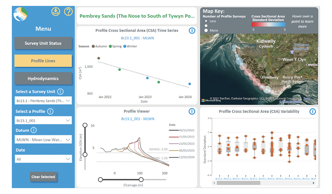
WCMC puts all the data collected online, Nelson said, making it easy for anyone to compare a scatter plot over time. In some locations, data was collected with traditional methods as long as 20 years ago, making it possible to really see how the beach has evolved.
To process the data, WCMC uses Pix4D software and its own bespoke solution.
“We graph and plot data compared to what we call influencing factors,” Nelson said. “For example, wave energy at a section of the beach might have dropped significantly. If we can show it happened after a storm, we can see what level of storm caused it and where vulnerable properties are at risk.”
Joyce uses her coastal research to inform better ways to automate workflows and give local counsels the ability to have “rapid assessment of the coastline they’re responsible for.” With this information, communities also have more ownership of their coastlines.
“We’re trying to understand how frequently changes are occurring,” she said, “and what impacts that might have on local ecosystems, people, the economy and social aspects as well.”

LOOKING AHEAD
Propeller Aero started combining drone surveys with sonar surveys taken via unmanned watercraft, making it possible to create a full 3D map that captures the coast and the seabed for a more complete picture. Smith expects to see more of these technologies coming together in the future. He also sees local governments managing surveys and the data collected themselves, “because it’s happening in their backyard and they want to do something about it.”
Nelson expects flight times to improve, and for the technology to continue to come down in price. He’d also like to see drones on standby at fixed locations, ready to autonomously fly before and after large storms.
For NOAA, the technologies they sent out to monitor hurricanes Helene and Milton are still in the evaluative phases, with the team trying to understand the impacts of the observations they provide on forecasts. Scientists need to continue to work on that, but eventually he expects drones will become part of the routine.
“I see transitioning from research projects to the operational way NOAA does business,” Mowitt said, noting he expects the same for the gliders and the Saildrone USVs. “I see us flying every hurricane, using UAS to get those high-res wind maps.”
With drones, we can better monitor environmental concerns like rapid storm intensification and erosion, improving hurricane predictions and identifying areas where erosion has taken hold. This advancing technology can lessen the impacts of both on individuals and communities.