The BOREAL UAV can fly much farther than the range of the UHF comms it’s equipped with. Solution? Get new comms!
Sometimes you design a product so well that it exceeds the capabilities of its supporting network.
Then what you must do is re-design the network around the successful product.
Such was the case with BOREAL, a fixed-wing UAV capable of extreme long-distance flights. These distances are so long, in fact, that they extend well beyond the range of the radio-frequency technologies sending data back to the UAV’s real-time monitoring and control crew. In missions to record video far out at sea or in remote desert areas, BOREAL’s 800 kilometer range takes it far past the roughly 100-kilometer range of UHF (ultrahigh frequency) signals used to transmit the video footage it films. The integration of satellite communication into the UAV’s supporting network transforms this limitation into a success story and provides new opportunities in intelligence, reconnaissance and surveillance (ISR), particularly in the maritime domain.
An immediate application is the aerial surveillance of fishing boats in remote ocean areas, for visual identification of boat registration numbers to control poaching and other illegal activities. BOREAL is also very useful in supplying essential research data, collected in wild and remote ocean areas, for the use of climate scientists and weather forecasters. Many desert and mountain applications—basically wherever there is an absence of ground infrastructure—can also be foreseen.
The solution devised by BOREAL and its partner Atmosphere, under project financing by the European Space Agency (ESA), has been to connect the UAV and its operators via satellite resources and satellite communications (SATCOM) technology.
In this project, the ground crew, that operates in the range of the drone, is able to receive the video from the camera and send back commands as usual, using BOREAL UHF’s native antenna. A SATCOM relay is installed on the ground, in the area of the drone’s mission, to give the control to a remote team, located far from the mission area. This remote team is able to send commands to the camera and receives the video, using the satellite connection and the UHF link. It was thus shown that ISR missions can be operated beyond radio ranges.
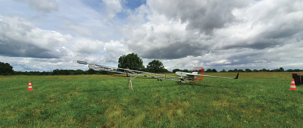
A GNSS receiver aboard the BOREAL is used along the flight path for tracking and monitoring flight operations and stamping the in-situ measurement with the precise time and location. BOREAL is a fixed-wing system that can travel 800 kilometers, at a distance up to 250 kilometers from the BOREAL Ground Station. It has a wingspan of 4.2m, measures 1.7m in length and has a maximum take-off weight of 25 kilograms, affording up to 7 kilos of payload. The BOREAL UAV is launched from a catapult and lands on its belly, affording relatively short take-off and landing operations in the field. One of the drone’s most unique features is that it can adapt to any payload and is freely configurable to any suite or combination of sensors. “One of the specificities of our drone is its modularity, which allows it to integrate several types of payloads,” BOREAL President Marc Pollina said.
DEMONSTRATIONS
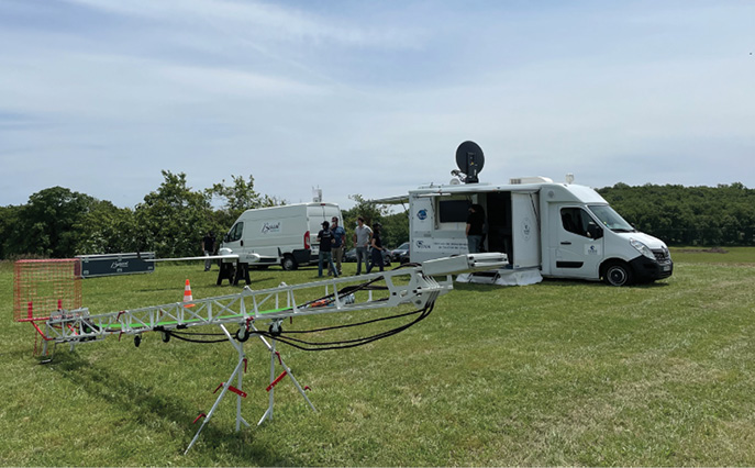
The experimental project takes place in two feasibility phases. The first, a technical feasibility phase that took place in May 2021, relayed the control of the camera on a remote site with ground SATCOM means. This demo was successfully conducted, as shown in the photos accompanying this article. The second phase will be conducted in January 2022 to evaluate two SATCOM technologies onboard the UAV, using two satellite systems.
The first is a geostationary system, the Inmarsat constellation of four telecommunications satellites providing global coverage. Each satellite supports 89 beams, giving a total coverage of approximately one-third of the Earth’s surface per satellite. In addition, six steerable beams are available per satellite, which may be moved to provide higher capacity to selected locations.
The second system demonstrated is the Iridium Next constellation consisting of 66 active satellites in near-polar orbits. In 2022 a campaign in the maritime domain will take place over a period of several days or weeks.
PARTNERSHIP WITH CNES
BOREAL and the CESARS platform of the CNES team partnered to demonstrate the ability to pilot the ISR drone’s video camera from a remote site of the operational area, via satellite communication.
Located at the CNES headquarters in Toulouse, France, CESARS is the support and expertise center for satellite telecommunications uses. Its role is to support companies and public entities wishing to discover and test satellite telecommunications equipment. CESARS is one of the links in the Connect By CNES program, which offers a range of services to businesses: technical expertise (access to data, patents, space technologies, navigation, Earth observation and telecommunications), financing, training and even incubation counters.
To carry out its mission, the CESARS center has several technical resources: a laboratory equipped with a fleet of commercial off-the-shelf equipment (metrology tools, SATCOM terminals with associated subscriptions), vehicles equipped with a test bench to measure the performance of mobile antennas, and autonomous access to bandwidth on a satellite, allowing great flexibility for demonstrations. This service is free.
BOREAL and CESARS Collaborate at several levels, including material support:
This includes loan of several pieces of equipment, such as the Aviator UAV 200 antenna for the direct Edge-to-ground link, the Explorer 8100 GX antenna for establishing a ground-to-ground relay between a field remote operation and the command center, and a DEKA 65 antenna for an end-to-end managed link on a satellite partially operated by CNES. Also available from CESARS, and key to carrying out these demos, is video encoding and decoding equipment, etc. Other support includes consulting services in technology intelligence, subscriptions, pricing, implementation and preparation of test architectures, and more.
In the first demonstration in May, BOREAL and CNES gathered at a test site operated by ONERA, the French aerospace laboratory. CNES provided an Explorer 8100 GX antenna for use with the Inmarsat constellation.
Overall, the satellite connection, whether via Inmarsat or Iridium opens up several new perspectives for BOREAL:
• to become a major player in the maritime sector, encompassing traffic surveillance and illegal fishing detection
• new opportunities to meet market needs by operating cameras remotely, in otherwise inaccessible areas
• enabling remote teleoperation at reduced operating costs: with fewer people needed at the deployment site, with their actions limited only to take-off and landing, while the SATCOM results can be directed anywhere in the world
• increasing long range video surveillance capabilities by removing the UHF range limits on real-time video, to be limited only by the 800-kilometer range of the UAV
• access to extremely large and remote areas, at closer range than can be achieved by satellites and at a much lower cost than surveillance airplanes.
For more information visit, BOREAL.