Drones fly through the air, and so naturally scientists are now using unmanned aerial systems (UAS) to help research the skies and help solve mysteries about hurricanes, tornadoes, weather, climate and other aspects of the atmosphere. Such research might not only help save lives and money, but also end up making flying easier for drones themselves with better weather forecasts.
IN THE HEARTS OF HURRICANES
A critical way drones can support atmospheric science is by researching hurricanes. An increasing number of these cyclones have struck the United States in recent years with devastating results, and many scientists expect this trend to continue in the years ahead. According to the National Oceanic and Atmospheric Administration (NOAA), the six most costly natural disasters in U.S. history were all hurricanes—in order, Katrina, Harvey, Maria, Sandy, Irma and Andrew. The agency estimated Katrina alone cost $170 billion and killed at least 1,833 people when it struck in 2005.
For decades, NOAA has sent its Lockheed P-3 Orion “Hurricane Hunter” four-engine turboprop recon aircraft through the eyes of hurricanes as flying labs to gather storm data. But they’ve rarely flown in the especially violent part of the eye close to the ocean, and many key secrets about hurricanes lurk at the atmospheric boundary layer—the lowest part of the atmosphere, where it meets the Earth’s surface. Consequently, the very complex process of how the lower eyewall draws energy from heat in the water remains uncertain, mostly due to the lack of detailed observations at that level.
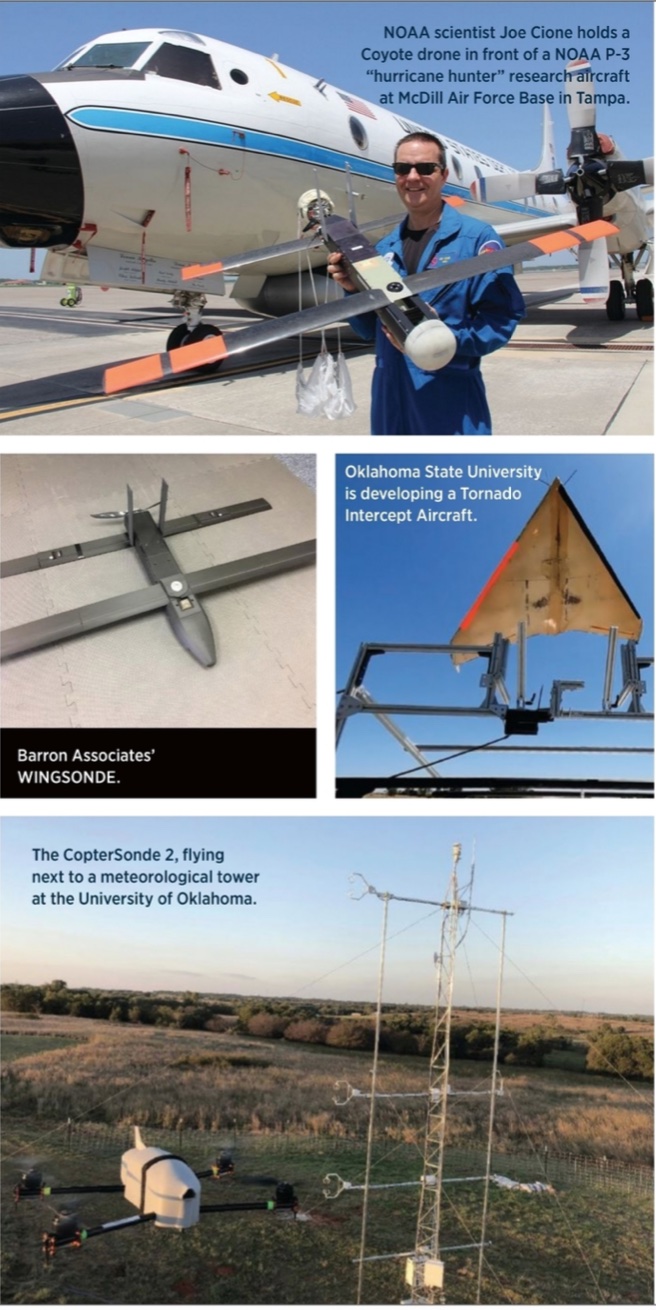
“You have 60-foot waves spraying all over the place and winds whipping over 100 miles per hour,” said Joe Cione, a senior research meteorologist at NOAA’s Atlantic Oceanographic and Meteorological Laboratory’s Hurricane Research Division in Miami. “It’s a very difficult place to try and sample, let alone understand.”
Currently, P-3s pepper hurricanes with expendable sensor packages known as dropsondes, which gather atmospheric data as they float down on parachutes. “They can give us snapshots of what is going on in a hurricane, but the view each gives us as it falls is like that of a straw or a toothpick,” Cione said.
In contrast, drones could help scientists safely get direct and continuous readings over a wide area of the lower eyewall, including the strength and location of a hurricane’s strongest winds and how far the storm’s winds extend from the eye. “Dropsondes have a couple of minutes before they hit the ocean, whereas these drones can stay over an hour in the air,” Cione said.
This drone data could shed light on how strong and how quickly a hurricane will develop, predictions that could help save countless lives and reduce hurricanes’ devastating economic impact. Getting a better idea of what is going on in the atmospheric boundary layer at the eyes of hurricanes will hopefully “improve the physics of the forecast models,” Cione said.
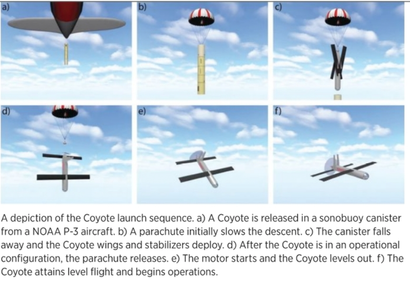
In 2014, NOAA launched the first drones deployed directly inside a hurricane, Raytheon’s Coyotes, from a P-3. Each drone was released in the same kind of tube that normally carries a sonar buoy. After a parachute slowed its descent, the canister fell away, Coyote’s wings and stabilizers deployed and the parachute detached. The Coyote’s motor then started, with the drone quickly achieving level flight and beginning operations. The drone can fly for more than an hour and up to 50 miles from its host aircraft.
In 2017 and 2018, Coyote drones were able to analyze the lower eyewalls of hurricanes Maria and Michael. The disposable aircraft successfully collected measurements on temperature, pressure, moisture, wind speed, wind direction and sea surface temperature at wind speeds of up to 194 miles per hour, and gathered the first direct readings of turbulence in a hurricane eyewall at altitudes below 150 meters. The information was consistent with the limited measurements P-3 flights have gathered from the lower eyewall, supporting the accuracy of the drone readings.
“We’re not getting snapshots in the violent parts of the storms with drones—we’re getting more of a movie,” Cione said. “That gives us a better idea of what is happening to improve forecasts and where the most violent part of the storm is, and deem what is best with emergency managers—do we evacuate an area or not?”
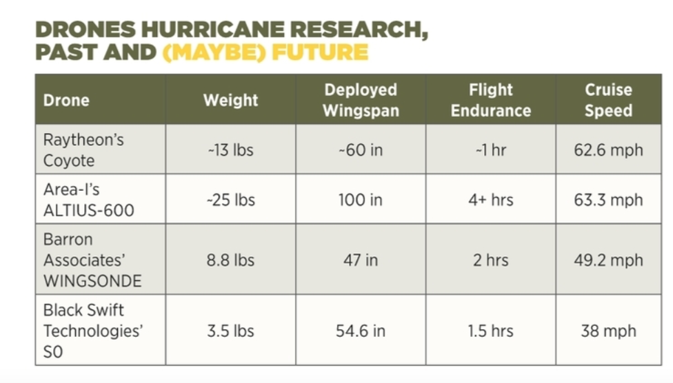
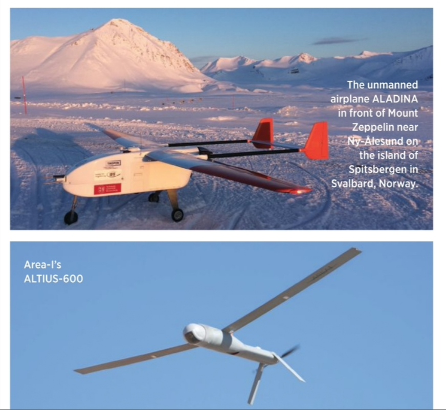
NOAA’s experiments with the Coyote highlighted areas in which they wanted even better results. The agency is now testing three small UAS platforms for hurricane research—Area-I’s ALTIUS-600, Barron Associates’ WINGSONDE and Black Swift Technologies’ S0. “We want them to drop into the eyewall and spiral down,” Cione said.
Each fixed-wing drone is designed for aerial tube launch like the Coyote, but as an upgrade from the Coyote in terms of capabilities, such as “an ability to fly 1.5 to 5 hours, depending on the platform,” Cione said. They should also fly further—up to 150 nautical miles from the deployment aircraft—and, in addition to measuring atmospheric pressure, temperature and sea surface temperature, should also display wind velocity and turbulence in 3D, he noted.
In addition, these drones will measure sea height with a laser altimeter or radar altimeter, as “we want them to fly low, but not so low as to hit waves,” Cione said. “That data also gives us information on the waves themselves to let us do more advanced science.”
The drones may employ a number of different techniques for keeping in contact with a crew on a P-3, including radio, satellite communications or a proprietary system used with dropsondes known as AVAPS (Airborne Vertical Atmospheric Profiling System). “With AVAPS, a dropsonde can still send data from 200 kilometers away,” Cione said. Such long-distance flights “are beyond visual line of sight [BVLOS] for sure,” he noted. “But in terms of getting clearances for such flights, these are a unique environment—planes will not normally fly in a hurricane.”
“The ultimate game plan is for autonomous flight, not preprogrammed flight plans,” Cione said. “With AI, the hope is that a UAS can feel out the environment with its sensors and make decisions on where to go based on what the environment tells it. That’s the end goal in a couple of years.”
POLAR INVESTIGATIONS
The Arctic has become a focus of climate research because the impacts of climate change are seen earlier there than in most of the rest of the world, and with more immediate and severe consequences. The Arctic is warming at a rate almost twice the global average, and much remains uncertain as to why that is. Drones could help scientists gather more data to shed light on the complex interactions between the atmosphere, ocean and sea ice in the Arctic.
Scientists in Germany have designed specialized drones to analyze the atmospheric boundary layer in the Arctic. One focus is on the formation of the smallest aerosol particles in the air there. Though less than 20 nanometers, or billionths of a meter wide, they can influence cloud formation and thus play a major role in climate. Yet they are difficult to monitor and require strict control of temperatures within the instruments used to measure them.
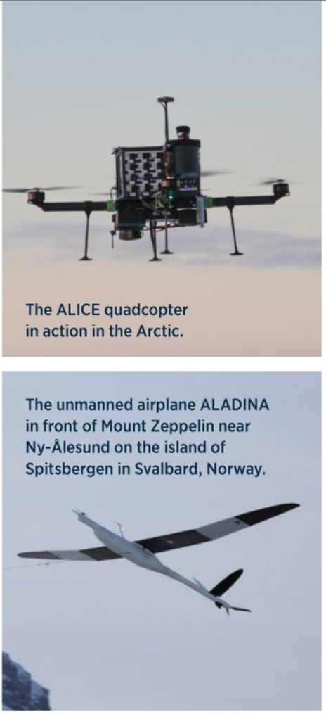
The researchers developed small UAS platforms such as the fixed-wing ALADINA (Application of Light-weight Aircraft for Detecting IN-situ Aerosol) and MASC (Multi-purpose Airborne Sensor Carrier), as well as the quadrotor ALICE (Airborne tooL for methane Isotopic Composition and polar meteorological Experiments). They tested these drones in Ny-Ålesund, the northernmost village in the world, on the island of Spitsbergen in Svalbard, Norway.
Flying drones in arctic conditions can bring a variety of challenges, and innovative solutions have been crafted to meet them. For example, when ALADINA lands, concrete and ice do little to slow it, so it has been equipped with electromagnetic wheel brakes that feature an adjustable anti-lock braking system to enable short landings on those surfaces. The researchers compensated for the added 200 grams of mass by removing parts of its fuselage.
Another challenge for ALADINA involved how its particle measurement instruments were strongly affected by the temperature fluctuations seen during operations in extreme cold. In response, the scientists developed ways to insulate, heat and control air flow within the drone’s front compartment.
When it came to ALICE, the scientists made the quadcopter’s arms removable and its frame compact. This helped it fit in the limited space and door width at polar research stations and on the German research ship RV Polarstern.
For MASC, at cold temperatures below -10 degrees C, the rubber bungee cord it used to launch lost its elasticity. As such, the researchers crafted a way to launch MASC with a winch.
All in all, ALADINA helped measure aerosol particles of different sizes in different areas, identifying where new particle formation was taking place. ALICE helped analyze the detailed structure and short-term variability of the atmospheric boundary layer during a cruise to a glacier in Greenland. And MASC assisted in capturing high-resolution measurements of atmospheric turbulence, which is a key factor in particle formation.
“UAVs are giving us the opportunity to close the observational gap between stationary ground measurements and aircraft measurements,” said researcher Magnus Ole Asmussen at the Technical University of Braunschweig’s Institute of Flight Guidance in Brunswick, Germany.
WHERE AIR AND LAND MEET
In addition to analyzing the atmospheric boundary layer over the sea and at the poles, drones are helping scientists investigate this layer over land as well. “Drones are giving us a great opportunity to probe an area that’s never really been looked at before,” said Bruce Baker, a senior scientist at NOAA Research’s Air Resources Laboratory’s Atmospheric Turbulence and Diffusion Division. “There is much we do not know about how the land interacts with the atmosphere. Weather towers around the country go up maybe 30 feet; weather balloons are released at only about 100 places across the United States, only twice a day; and different types of remote sensing devices do not really probe the lower atmosphere. So there is a big gap in measuring the physics of the atmosphere from the ground up to a mile up.”
In addition to better sampling of the largely unexplored atmospheric boundary layer, drones also offer adaptability compared to other weather analysis technologies. “If there is an area that is becoming interesting that is not well covered observationally, we can send a drone there remotely and rapidly get an update,” said James Pinto, a project scientist at the National Center for Atmospheric Research’s Research Applications Laboratory. Moreover, drones are completely reusable, whereas weather-balloon borne instruments are not, he noted.
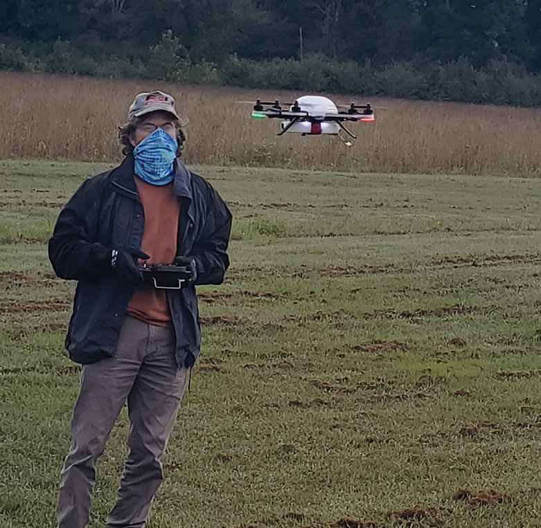
One example of a specially designed weather-monitoring UAS (WxUAS) is the quadrotor CopterSonde from the University of Oklahoma’s Center for Autonomous Sensing and Sampling. “We initially had the intention to find a commercial off-the-shelf copter we could buy and equip with our own sensors, but quickly learned there was nothing on the market suitable for our needs, so we developed and built a drone ourselves,” said Phillip Chilson, the center’s director. “We’ve been working on the CopterSonde probably about four years now, and it’s a very robust platform now.”
One commercial drone Chilson and his colleagues considered had a flight control system they could not fine-tune to record position and time data with sensor measurements. Another lacked places to install sensors in a way that would not get disrupted by heat from the motors or grit kicked up from the ground by rotors.
In contrast, the CopterSonde is designed to help scientists collect temperature, pressure, humidity, wind speed and wind direction data in a vertical column. “The flight control system is designed such that the CopterSonde always faces the wind and can therefore get better wind estimates,” Chilson said. “And knowing the platform faces into the wind, we put the sensor inlets at the front of the CopterSonde and use ducted fans to pull air down into the sensor, all to make sure the sensor is not perturbed by the heat of the motors.”
Chilson noted that weather-balloon-borne sensor packages known as radiosondes are often thought of as the gold standard for measurements within the meteorological community, but the CopterSonde “has measurement capabilities that are probably on par if not better than the radiosondes used by the National Weather Service or other weather services around the world. And we have more precise control of where the CopterSonde will be, as compared with radiosondes, which drift with the wind.”
One goal of weather drones is precision meteorology—”improving forecasts at really small scales,” said Jamey Jacob, director of Oklahoma State University’s Unmanned Systems Research Institute. “For example, a couple of weeks ago, we had a severe ice storm that led to power outages here for two weeks that occurred over a relatively small area. That kind of event is really hard to predict right now because we don’t have that kind of data to go into weather prediction models. With climate change, this will be even more important, since things will become more unpredictable, with greater extremes over smaller regions.
“It really boils down to being able to report and predict micro-weather conditions,” Jacob said. “The atmospheric models we have are only as good as the data going into them. More data means better predictions. This is going to be a real game-changer for weather forecasting.”

UAS FORECASTS
Baker and his colleagues have used a multirotor Meteomatics Meteodrone and a fixed-wing Black Swift Technologies S2 UAS to conduct short-term field studies that collected atmospheric data for the National Weather Service office in Morristown, Tennessee. They’re now developing a long-term test bed to see how well drones can help weather forecasters with their predictions. “We are getting FAA approval to fly up to 1 kilometer,” Baker said.
Ultimately atmospheric scientists would like drones to collect data with BVLOS flights, which currently face restrictions under FAA regulations. “For us, this hasn’t been a strong hindrance, as we are flying vertically and can keep eyes on the platform to 4,000 or 5,000 feet, pushing the ceiling of what the FAA is allowing us to fly to,” Chilson said. “We will need beyond visual line of sight at some point, maybe higher than 6,000 feet, and we will need it if we are flying into clouds.”
Drones are also helping scientists investigate tornadoes. “There is still a lot we do not know about why tornadoes form,” Jacob said. “Currently, we have storm-chasing vehicles that can get close to tornadoes but not close enough to get the measurements we need. We also drop off sensors on the ground and hope that tornadoes will stay on their expected tracks and pass over the sensors so we can gather data, but then that’s only data from the ground and not in the air. Hopefully unmanned aircraft can help fill this gap.”
Oklahoma State University is developing a Tornado Intercept Aircraft, “a jet-powered fixed-wing vehicle we’re using to push the boundaries of the art of the possible,” Jacob said. The 18-pound aircraft has a 44-inch wingspan and can reach speeds of more than 150 miles per hour. “It’s designed to be car-launched—it sits on top of a storm-chasing vehicle,” he said.
The aircraft is made of Kevlar. “It’s not designed to fly into a tornado, but in the severe weather near a tornado, where we still expect to see a lot of high winds and debris lifted up by the wind,” Jacob noted.
Improving weather forecasts with drones may also end up making life easier for drones, as “smaller UAS are more susceptible to weather,” Pinto said. NASA is funding a project called WINDMAP (Weather Intelligent Navigation Data and Models for Aviation Planning) to use multiple aircraft types to gather atmospheric data and generate real-time weather forecasts they can use, Pinto explained.
In addition, WINDMAP aims to have drones map out wind conditions in rural and eventually urban locations for drone delivery and urban air taxis, “which are really susceptible to wind conditions, such as the urban canyon effect in big cities, where lots of winds can change quickly,” said Jacob, the program’s principal investigator.
As drone use expands, “I would like to see partnerships between the weather community and commercial drone companies to get data from their aircraft,” Pinto said. “We can then incorporate their data into models to improve prediction, especially for the next 12 to 24 hours. Commercial drones could provide part of the solution for the weather predictions they need.”