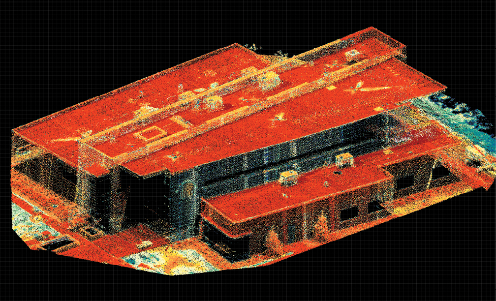
RIEGL USA headquarters after a miniVUX-SYS scan, with enhanced vertical wall capture.
For more than 40 years, RIEGL has innovated in researching, developing and fielding LiDAR scanners, rangefinders, distancemeters and data processing software. But when RIEGL contracted for a new North American headquarters, the global company would have a unique customer—itself. RIEGL and builder DPR Construction would use RIEGL LiDAR terrestrial scanners and UAV-based technologies for the new building in Winter Garden, Florida, a half-hour from its previous Orlando offices—and 5,000-plus miles from RIEGL’s world center in Horn, near Vienna, Austria.
“We want to accommodate our business growth” RIEGL USA President Johannes Riegl, Jr., said, citing not only the U.S. market but Canada, Central America and South America. “And we felt it was the right time to get started.”
The resulting 18,500 square foot building on an approximately 19-acre site had its opening ceremony on December 6th. The structure includes not only business offices but modern training rooms and employee amenities indoors and out. RIEGL’s R&D remains mainly in Austria, but the Florida facility also features ranges for equipment testing and calibration, and a hologram table to visualize LiDAR data.
The RIEGL-DPR collaboration itself contained an element of R&D. “We know what our systems are capable of,” Riegl said. “But we had not used them in a construction project ourselves. So yes, we were our own client in this project. It was a really good experience for our team,” he added, “because nobody in our company usually is going out to scan a project site daily.” As for DPR, it would become at once a project team, purchaser of RIEGL equipment and deployer of unmanned laser systems going forward.
A Willing Partner
Redwood City, California-headquartered DPR is a commercial-construction giant, posting just under $6 billion in revenue in 2018. Yet the 30-year-old company lists “ever forward” as one of its core values. DPR began its UAV use back in 2013, and today flies 30 UAVs with approximately 40 pilots.
Contract bidding came down to three companies, “all of them great,” Riegl recalled. “What made DPR really stand out is that they definitely had the most advanced approach to using LiDAR, to using new technology to aid the construction process. In addition, they had experience in virtual design and technology. Their interest in RIEGL sensors was also crucial.
“The key was some of their experience, of course,” Riegl continued, “but also their interest to work together on documenting this site very accurately using different methods. We’ve used terrestrial LiDAR, we’ve used UAV-based LiDAR, mobile airborne data, and bringing all these data sets was pretty neat. And it really helped DPR to find several areas of concern they addressed in time.”
RIEGL VZ 400i 3D laser scanning system data capture of pre concrete pour.
Domains and Systems
With a design by local architect Toby Walker in hand, the official groundbreaking occurred in February 2020. But DPR was on-site in August 2019, to capture overall existing conditions and shoot an orbit video modeled in animation of building the headquarters.
That helped make DPR’s case, but the alliance wasn’t a predetermined slam dunk. “This was uncharted territory for both companies,” recalled Stephen Maciong, U.S. technical sales & integrations for RIEGL, about the multidomain, multi-technology workflow to come. “There were learning experiences.” Each side’s expertise would prove to be vital.
The project would rely on a mix of airborne and terrestrial systems, photogrammetry and LiDAR, noted Stuart Drahota, DPR’s southeast field technology group leader (in keeping with the company’s California provenance, these descriptors are seen as roles rather than titles). “For visualization, the photogrammetry is a lot easier to do and the results are pretty good. With LiDAR, there would be denser point clouds, more accurate. If you’re really trying to dial in, I feel like the LiDAR data is a lot better.”
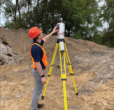
In January 2020, DPR captured site survey data using a Skycatch RTK Edge1. Terrestrial Laser Scanning (TLS) followed. “We were involved in pre-site work, moving dirt around and setting up five control points that we used throughout the duration of the project to really locate all the data,” Drahota recalled. “That was kind of our base, and then we build on top of that.
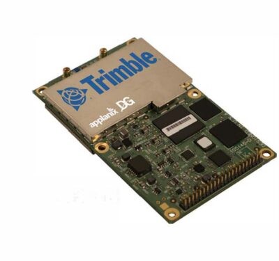
“The focus of a lot of our QA/QC was actually using the terrestrial system,” Drahota continued. Thirty to 50 TLS LiDAR scans were captured in a typical day; this data was tied in with control points/ GCPs directly to the BIM model. We would scan in local State Plane Coordinates and then transfer to local project plane for analysis. [RIEGL’s] RISCAN PRO allows for pre-setups of transformation. After we got it set up, it was easy.” A VZ400-i 3D laser scanning system purchased from RIEGL allowed data capture at such critical moments as pre concrete pour scanning and tilt wall erection. TLS data was processed in RISCAN PRO, and REVIT was used for business information modeling. Drahota found the VZ-400i’s real-time data flow to be “awesome. My opinion is it’s the best terrestrial scanner.”
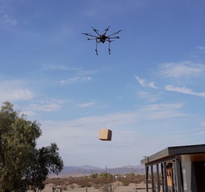
After a test flight in June, an M600 Pro was outfitted with RIEGL’s lightweight MiniVUX-1UAV airborne laser scanner, with Waveform-LiDAR technology for echo digitization and online waveform processing. “The value of that is being able to capture the size of the project as quickly as possible versus using TLS,” Drahota said. Using a high-end, higher-priced LiDAR drone required new processes and procedures, including for risk mitigation. “We rebooted, and kind of took it to the next level.”
UAV missions using mostly Mavics and Phantoms for photogrammetry ran through November. The data was captured in state plane coordinates and translated to local project plane, to track the project and compare the data to the construction [BIM] model. Typical flights ran 15-25 minutes, about 75 meters off the ground. Speed was set at 4 meters per second to get the desired point density. Traditional photogrammetry yielded 250-450 photos per dataset, which included both the building and the entire property.
Each flight also involved aerial capture with LiDAR.
“What we did is take two, three different data sets,” Drahota said. “We would fly with photogrammetry and register those photos either in Skycatch or DroneDeploy. If it was ULS [Unmanned Laser Scanning] LiDAR, then Stephen would process that in RIPROCESS, RIEGL’s [data visualization] software. And I would import that either directly into RealWorks [a Trimble design-build point cloud processing software] and then do my alignment in there, or I could bring it into RISCAN PRO and basically create a new scan station and register it to the TLS data directly.”
Scanning modes and workflow needed coordination. Drahota used his flight experience to manage data acquisition; Maciong set up the LiDAR sensor in the UAV platform to record the LiDAR data and compare data sets. “You need your data acquisition team and you need your data processors as well,” Maciong said.
Riegl’s assessment: “It was a good proof of the robustness of the performance of our scanners. The whole site continuously and some critical stages were scanned almost every day. Speed matters on a construction site to be really safe and spend as little time as possible.”
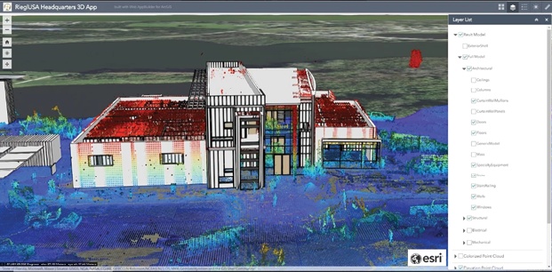
Using RiMAP to convert LiDAR data into Esri’s ArcGIS
Problem-Solving
“In the beginning,” Maciong said, “the mission plan was simple: ‘We’re going to do a simple lawnmower pattern. But then you look into the data sets and see that you can’t pick up building facades with a simple lawnmower pattern: we need to have perpendicular flight lines, with different data captures and different periods.”
Challenges from COVID to construction contradictions also arose—and were resolved.
“My biggest surprise was the project was more or less delivered on time,” Riegl said about the just-slightly-delayed opening. “We lost a couple of weeks every now and then. And then we managed to get those back. I think a lot of appreciation needs to go to DPR for keeping strict measures in place—safety briefings, and they have been very, very strict about wearing masks and following the CDC-recommended COVID-19 guidelines.”
A lot of the work was done to spec. “We didn’t have to move anything after the panels were cast,” Drahota said. “That’s huge for the flow of construction.” Hundreds of electrical and plumbing items were positioned spot-on. When an iPad overheated, Drahota used his flight experience to bring the drone back without activating the return-to-home function.
As for concerns, an inch-or-so deviation with a concrete slab was caught pre pour. But a major issue surfaced when it came to some of the wall footers, which support the foundation and prevent settling.
“That day, I think we did ULS, traditional photogrammetry and TLS data,” Drahota recalled. “There were two large footers that needed to get moved a couple of feet and some anchor bolts that were off. It was a grid line issue; one of those things that happens in construction.”
This find was “absolutely critical,” explained DPR Project Manager Bryan Burless. “If we would have put those foundations where they were originally laid out and where the concrete contractor was ready to put them, it puts the foundation for the column in the wrong spot. I’ve been on jobs where you have something that’s off even just a couple inches, and every time you think you solved the problem, some associated problem comes up.”
Drahota: “I remember sitting in the conference room the morning of the pour, and I was like, ‘I think these are off.’ We called the superintendent: ‘We’ve got to either move it or stop the pour.’ Yeah, it was a mistake, but we caught it. It was pretty powerful, right out of the box.”
The team even found a minor placement error with the computer model. “We were looking at it,” Drahota recalled,” and we’re like, ‘Oh, everything’s off!’ Then we found that the model was in the wrong place. The scan actually validated the model!
“That’s the beauty of it,” Drahota agreed, “when you know that the data is tight.”
Riegl, though he saw project supervision as “superb,” would be on-site a couple of times a day through the project, not to micromanage but because of several years invested in turning concept into reality. “I somewhat like that we found some issues through using our technology, because that’s proof of concept.”
Drahota agreed. “It’s like they built it future-proof. Just working with them was eye-opening from a technology perspective. We came up with five or six new workflows to utilize the data and do different analysis. They’re really focused on lasers, and they’ve really perfected their craft.”
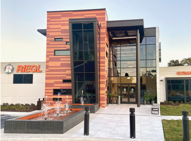
RIEGL’s new headquarters, upgraded for business, training and amenities.
Lessons Learned
“We’ve been operational since December,” Riegl said about the headquarters. “That was my biggest surprise—it’s a good one.” Fencing is being finished and a helipad will be completed during 2021. Regular calibration of airborne and mobile laser scanning systems now can take place in the U.S., which reduces shipping time for customers. A large production facility is being built at the Austria headquarters, and, while the construction specifics are different, data analysis and workflow improvements learned in Florida can be applied.
“I’m trying to get out there one more time, just to put a bow on it,” Drahota said about the Winter Garden facility. “I’d like to do one last ULS capture, and one more interior, and then just combine those two, and be like, ‘OK, here’s the perfect as-built of the facility,’ and have that to showcase.” Maciong hopes for a final MiniVUX-1 data collect, to yield a time lapse for the entire project.
“From a user perspective, we’ve had a beautiful experience,” Riegl said, “a good leaning for collaborating efficiently.”
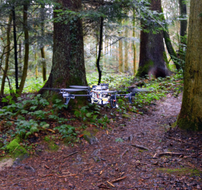
DPR has integrated its VZ-400i into its workflow, completing 100-plus scans and applying new knowledge to a massive datacenter project. A late mission at the RIEGL site tested a MiniVUX-2UAV, which is especially useful in restricted spaces or with payload limitations. Flying north-south and east-west offered 30% more vertical data than the traditional lawnmower pattern.
That test flowed into surveying with RIEGL at a nearby 330-acre site, a size where LiDAR can maximize its advantages. “We did it in three flights with a MiniVUX-2,” Drahota said. “It was four hours of time on site, with three different deployment zones, and we did it in about half a day. And then Stephen processed the data in about eight hours to sub-millimeter accuracy.
“To do that with a TLS would have taken me weeks—the photogrammetry would have been the same capture time, but it would have taken at least 24 hours in DroneDeploy to get that processed. And in these vegetated areas, you can get all the way down to the ground.
“It’s insane—the efficiency is so remarkable.”