Underwater inspection firms are creating new imaging techniques and applying large-data analytics to track infrastructure deterioration and assess damage. This helps maintenance managers determine the timing and cost of repairs.
Whether it’s to track natural deterioration or evaluate hurricane damage, inspection teams are adopting and adapting an emerging class of underwater robots. These systems are designed specifically to inspect bridge supports, water pipes, retaining walls, dam structures and other elements essential to fully functioning infrastructure.
That technology will likely come into play as Midwestern officials scramble to assess flood damage across Nebraska and Iowa, where massive runoff from rain and melting snow caused a major dam to fail and an unknown number of large and small bridges to collapse. Many of the bridges that are still standing must be checked for safety.
One of the first things bridge inspection teams will likely be looking for is scouring—that is the hollowing out of the dirt and rock at the base of the bridge.
“The most predominant failure of bridges is from undermining of the substructure unit. So during high river flows it’ll wash out all of the ground that’s supporting the bridge and then the bridge will collapse on itself,” said Drew Garceau, the structural inspections program manager with Chicago-based Collins Engineers.
By law, bridges in the U.S. must be inspected directly by divers at least every five years. If the situation is potentially dangerous, however—that is, if the current is too fast, if trees are floating in the river or if there’s a possibility of hidden debris—the Collins team will lower 2-D or 3-D acoustic imaging sensors beneath the surface to determine whether it is safe to go in. Collins also contracts out for remotely operated underwater vehicles (ROVs) to survey areas for a sense of the situation before deploying divers.
The use of such imaging is two-fold, Garceau said. “You can deploy it before you send a diver into the water to determine what the diver’s getting into.” Second, like LiDAR sensors on drones, the 3-D point cloud produced by acoustic imaging can give clients a picture of the damage and what it’s going to take to fix it.
“A lot of clients want to be able to physically see a picture of what’s going on underneath the water rather than just see some paragraphs from notes and descriptions,” Garceau said. “So a picture underwater is literally like 1,000 words.”
DAMS AND PIPES
Dams of all kinds also need regular inspection and maintenance of their structure, outflows, retaining walls and the large penstock pipes that bring in water—sometimes over many miles. During the Midwest floods at least two people were killed when a number of dams collapsed, including Nebraska’s Spencer hydroelectric dam over the Niobrara River.
Inspecting hydroelectric dams is a specialty of Underwater Acoustics International LLC. (UAI). Based in Lafayette, Louisiana, the firm uses acoustic imaging and ROVs, along with robotic platforms and autonomous surface vessels, to inspect all aspects of a dam, including the water surrounding it.
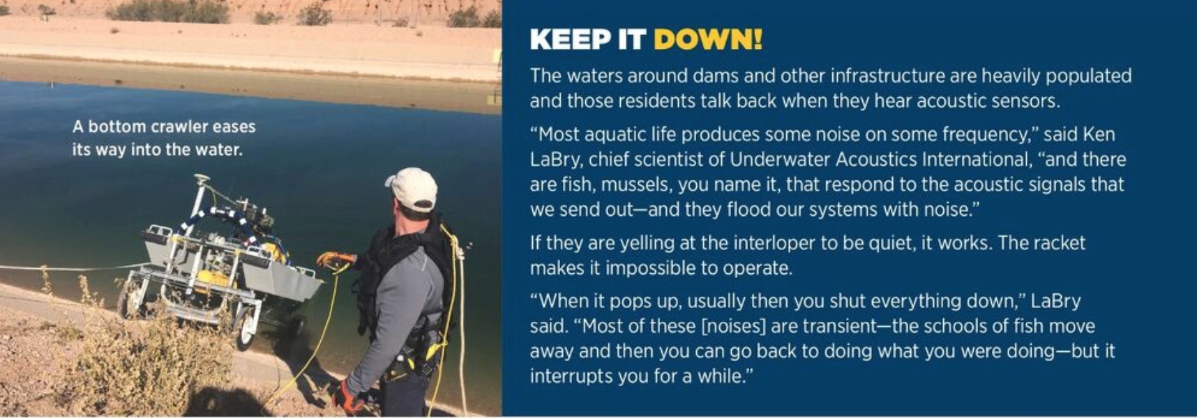
UAI uses unmanned surface vessels of its own design—essentially two pontoons with a suspended rack of acoustic sensors in between—to view the water bottom. The instruments are lowered into the water and the vessel runs along the surface, guided either by a remote-control operator or by a preprogrammed track or grid pattern. In addition to the instruments, the vessels typically carry cameras “so that a remote operator or a pilot can be able to navigate and avoid obstructions,” said Ken LaBry, UAI’s chief scientist. For a really close look, UAI also has tracked tethered vehicles that can roll across the water bottom either under operator guidance or along a preprogrammed path.
UAI has additional wheeled vehicles designed to inspect a dam’s steep walls. The robots are lowered using a tether that serves to both communicate data back to the team and provide the mechanism by which the robot is winched back up the wall.
“Many dams have a steep slope to the upstream side, say anywhere from a 30-degree to 60-degree slope on the upstream component of the concrete spillway for the dam,” LaBry said. “To properly inspect that, sonars and acoustic systems need to look along the surface. So, basically, we’ve developed robotic vehicles that we can deploy from the top of the dam down, and they actually roll down the dam in a controlled roll, gathering data so that we can map the entire face of the dam.”
The real challenge, however, is inspecting the tunnels and penstock pipes that carry water to hydroelectric dams.
The draft tubes that feed hydroelectric power plants range in length from 200 feet to 20 kilometers (12.4 miles), LaBry said, and the water may or may not be flowing during an inspection. “They can be large diameter pipe; sometimes they are tunnels just carved into the rock, sometimes they are concrete tunnels, sometimes they are concrete pipe.”
UAI is able to do 10-kilometer (6.3-mile) runs, he said, and is looking to add the ability to perform up to 16-kilometer (9.9 mile) missions.
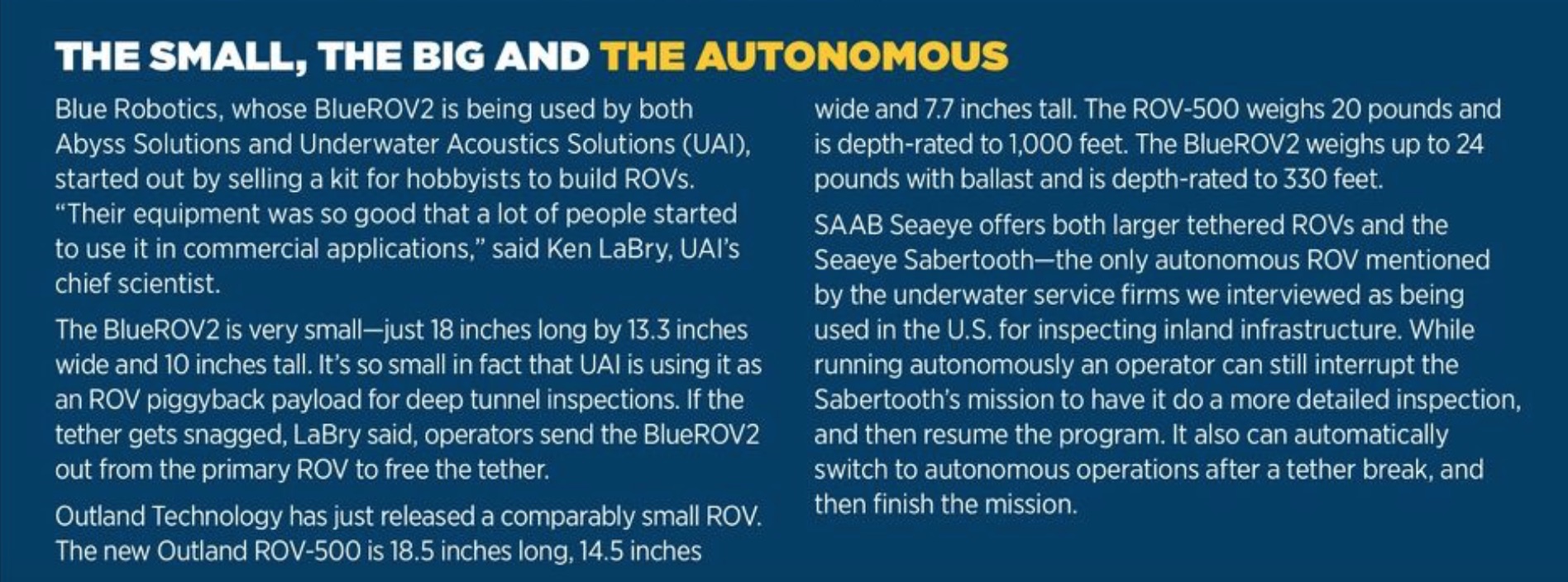
The company uses a combination of customized ROVs from firms including Blue Robotics, Outland Technologies and SAAB Seaeye. All of the ROVs are powered via tethers, which provide continuous monitoring and data transmission and can be used to pull the unit back if there’s a problem. The tethers also enable the team to track where an ROV is located in a tube, accurately marking spots for closer examination and repair.
Without a tether, LaBry said, you never really know where you are.
“There are inertial systems that don’t work on GPS or any of that information, so they don’t require being exposed to the sky,” LaBry explained. “However, those inertial systems kind of work on the rotation of the earth and, as a result, they drift and the drift is unpredictable. The drift starts immediately after launching them. So after they’ve been in the pipe for an hour or so they start to get very, very unreliable as far as determining their position.”
While tethers are valuable they come with trade-offs. It gets very costly to have somebody build very long cables, LaBry explained. Also, the tethers are neutrally buoyant but can lose that characteristic when water pressure is high—say at the end of a draft tube that runs 3,000 feet from the top of a mountain to a dam in the valley, a pressure depth of 3,000 feet.
The cables themselves have small air pockets in the polymer sheathing. At some point they compress to where they do not expand back. When that happens they’re no longer neutrally buoyant. That doesn’t keep the cable from working from an electrical, power or communications standpoint, LaBry added, “but it does allow the cable to then drag on the bottom, and that drag, say, if you got a mile of cable, can become substantial.”
PIPE CRAWLERS
Another inspection option is provided by specially designed wheeled robots that can roll through pipes, capturing images along the way.
Deep Trekker makes pipe crawlers as well as ROVs, though it was the ROVs that first led them to the idea of adding wheels.
A customer was using his ROV to do pipe inspections, said Sam Macdonald, the president at Deep Trekker Inc. in Kitchener, Ontario, Canada. He was working in a reclaimed section of the Everglades in Florida and million-dollar homes were sitting on what were once wetlands. “So the piping system was very important because if it broke down it could sink these homes,” she said.
The inspector said he was using the DTG2 ROV because it was waterproof and the pipes he was examining were completely submerged. He also told Macdonald he liked the unit’s portability.
Inspired by his experience, the company developed a fully submersible wheeled robot with internal batteries that comes complete in two carrying cases. These crawlers can fit into pipes as small as 6 inches, with larger units carrying extendable cameras for utility inspections. A rolling, tethered unit with magnetic wheels can inspect the walls of water tanks.
SOUND WAVES
Firms doing beneath-the-surface inspections may directly test the thickness of metal pipes or gather water and soil samples. Mostly, though, it’s about gathering images with visual cameras, sonar and other acoustics.
Like other firms, UAI uses acoustics to search surfaces for deterioration. But their technique is unusual.
“We’re looking for very high resolution,” LaBry said, “because we’re trying to define very sharp, abrupt but small changes like cracks and joints in slabs, and joints in pipes and tubes.”
Unlike acoustic systems that send out a ping perpendicular to the surface and then track how it’s reflected back, UAI transmits an acoustic wave along the target surface.
“As it propagates out along the surface,” LaBry said, “any undulation or change in the surface is reflected back to the acoustic sensor and mapped. It’s a reflection; it’s like a mirror—you can map it. And so, if there is a crack that has one shoulder of the crack higher than the other, even though there’s no gap, you’re still going to be able to observe it.”
With this technique and advanced signal processing, UAI has been able to achieve verified detection of a millimeter in width, he said.
UAI uses large-data analytics to compare new data on a specific pipe or surface to the initial baseline inspection and follow-up inspections. “We catalog and build a database of everything we know about every acoustic sample that we’re collecting,” LaBry said, “and then we build algorithms that go through that database looking for any changes or patterns that may be developing.” The geolocated results map the progress of deterioration to help clients determine where and when issues need to be addressed.
BIG DATA
UAI is not the only firm using data analytics to pull more value from inspection images.
Abyss Solutions, which is located in Houston and Homebush, NSW, Australia, is using a stereo system of visual cameras to take high-precision, high-frequency still imagery from multiple underwater angles. It then stitches those images together to derive a 3-D point cloud and create photorealistic 3-D models.
The advantage of this approach, said Mashood Naqshbandi, the firm’s chief commercialization officer, is that they are able to clean up the data in post processing to the point that they can “see” through turbid water—and then further clarify the images to reveal hidden features. “If we apply these processing filters we can remove that foreground information out of it so we can see the background much more clearly.”
The images are not only easier for clients to understand, they retain color and textural information. “One of the things that you can pick out during condition assessment is, for example, corrosion. Now corrosion you can detect visually by the color. You know rust is red. You cannot see that when you’re using sonar.”
Abyss is taking the processing of its point cloud data one step further by using machine learning to automate change detection.
The company has developed an algorithm that can look at all the images, identify possible defects and classify them automatically, Naqshbandi said. “So it picks up a whole bunch of things and then you can go manually and decide if it’s a fault or not.”
Moreover, he said, the algorithm can be tuned to err on the side of finding more possible cracks and other problems—or fewer, depending on the client’s needs.
Data analytics can provide other useful information. Collins, for example, uses 3-D point cloud data from acoustic images to calculate the amount of material and work that will be needed to complete a repair.
“It gives our clients peace of mind that they know with certainty what the cost of repairs is going to be,” Garceau said, “Rather than assuming that the project may require a $100,000 repair but [finding] actually, no, their estimate was way low, and it cost $1 million.”