John Deere
As a farming technique, walking the fields is as ancient as stone tools. Farmers still patrol the rows, looking for signs of disease and drought while guarding against thieves and weeds and searching for clues to better yields and the best time to harvest.
Fortunately, there’ll soon be an app for that.
On Jan. 6 the Federal Aviation Administration enabled the launch of the first commercial service in the United States able to legally use unmanned aircraft to gather data for farmers. With the FAA’s grant of their request for a waiver, Idaho-based Advanced Aviation Solutions (ADAVSO) and partners Empire Airlines and Blair Farms announced that their UAS sensing firm Empire Unmanned Aviation was open for business. The new service will deploy teams of operators across Idaho and eventually the eastern portions of Oregon and Washington state to scan fields for signs of disease, nutrient shortage and overly dry conditions. The firm has filed for the certificates of authorization (COAs) needed to fly in specific locations, said Steve Edgar, ADAVSO’s president and CEO, and hopes to be operational in time for the 2015 growing season.
eBee Ag, courtesy of SenseFly
“We’ve got the entire process from end to end complete—that’s from data collection to distribution to the end-user,” Edgar told Inside Unmanned Systems. “We’re striving for a menu or an a la carte service to the user. They can log on with a password, go to their field and their crops and their particular products.”
Hard on Empire’s heels are dozens of firms planning to offer ag-related sensing. As of the close of business Jan. 23, some 295 firms had applied for waivers under the FAA’s Section 333 program, according to an FAA spokesman. The waivers are necessary because U.S. regulations currently bar for-profit operations with unmanned aerospace systems or UAS—more commonly known as drones. Congress, however, empowered aviation officials to forgo the restrictions on a case-by-case basis under Section 333 of the FAA Modernization and Reform Act of 2012.
Of the posted waiver applications more than 80 mentioned agriculture as part of their anticipated operations. Though the majority included agricultural services as just one of a number of possible business activities, roughly a dozen companies, including one operation fueled by a pair of Monsanto subsidiaries, said they intended to make agriculture the center of their plans.
The focus on farming is easy to understand. Agriculture has consistently been identified as the top opportunity for UAS firms. ABI Research said in a Jan. 5 market study that agriculture would be the biggest contributor to the commercial market for unmanned aircraft weighing 25 lbs. or less. Dan Kara, director of ABI’s robotics practice and the study’s author, forecast annual global revenues for this commercial small UAS sector would rise to $5.1 billion by 2019. He told Inside Unmanned Systems he expected a quarter of that, over $1.27 billion, would come from agriculture.
The ABI forecast underscores the conclusion reached two years earlier by the Association for Unmanned Vehicle Systems International. Their study said agricultural applications, of all the possible uses of unmanned aircraft, would generate the greatest economic impact once UAS were integrated into the national airspace.
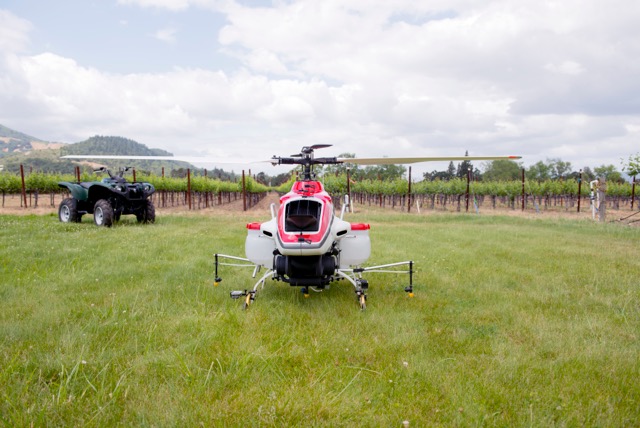
The RMAX by Yamaha, used to spray fields, has over 2 million flight hours.Yamaha
An Advantage for Farmers
The potential for farmers is clear. New research into the sensor readings or “signatures” indicating specific diseases or insect infestations are making it possible to spot problems from above, sometimes before they are visible to the naked eye. Topographical maps detailing differences in elevations of as little as ½ an inch can help farmers understand critical water flows—a capability vital in drought stricken areas. Insights from drones may even make it possible to customize plantings within a single vineyard and identify precisely which clusters of grapes are ready for picking.
Unmanned aircraft can also be used to improve on established techniques. Researchers in North Dakota, for example, recommend setting up a fertilizer benchmark in each field at planting time to determine how much fertilizer to apply to the rest of the field later in the year. The farmer splits the fertilizer he intends to apply, half at planting time and half in the summer. One strip in the field, however, gets double the full, intended amount of fertilizer in the spring. For the plants in that strip, a shortage of nitrogen will not be a limiting factor. When summer arrives the farmer gets an image of his field to get a normalized difference vegetative index or NDVI. He can then use that to program his equipment to fertilize the rest of the field to produce plants that match the benchmark set by the nitrogen rich test strip.
Up to now that image would likely be taken with a satellite, said John Nowatzki, an extension agricultural machinery systems specialist in the Department of Agricultural and Biosystems Engineering at North Dakota State University.
But drones can do something satellites can’t—fly below the clouds. Nowatzki was involved in a study last summer that illustrated how important that can be.
“One of our goals was to compare our UAS imagery with satellite imagery—with a satellite called RapidEye,” Nowatzki told Inside Unmanned Systems. “RapidEye was going to be flying over our fields every 10 days. Well, it was interesting; it can’t see through clouds and every day that that satellite flew over in May, June and July of 2014 it was cloudy. So it wasn’t effective at all. So if a farmer had been depending on the satellite imagery it wouldn’t have been available.”
It might have been possible to get the needed imagery with a plane. For some applications, however, only an unmanned aircraft will do.
“With a UAS you can get low enough and, with pretty much off the shelf cameras, you can get high enough resolution that you can see the corn as it first comes up,” said Robert Moorhead, an electrical and computer engineering professor at Mississippi State University and the director of the Geosystems Research Institute. “So by determining whether you have a good emergence earlier you can make a replant decision, if necessary, which would still allow you to plant within the window for optimal productivity.”
Part of what makes this possible is that drones fly relatively slowly—so their speed doesn’t blur the images.
“With a small UAS we can go 12, 20 miles an hour. With a fixed wing plane you’re talking hundreds of miles an hour,” said Moorhead, who noted that UAS cameras could achieve resolutions of an eighth of an inch.
UAS are also less expensive to operate.
“Fixed wings (planes) can put their wheels on top of the crop but the cost of flying that low with an aircraft is prohibitive,” said Moorhead. “They can do it—but it is much cheaper with an unmanned.”
UAS have the potential to provide data rapidly and reliably enough to enable entirely new applications at a combination of cost and image resolution that should give aerial vehicles an edge over satellites and manned aircraft for many services.
But the advantages of unmanned aircraft are not, however, a guarantee of business success.
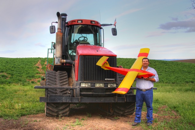
Farmer Robert Blair. Blair Farms is now a partner in Empire Unmanned Aviation.Photo courtesy Blair Farms.
Making It Work
One issue is the inefficiencies created by regulatory limits. In the United States nearly all of the companies given section 333 waivers, including Advanced Aviation Solutions, must either limit the duration of their flights or end each sortie with 25 to 30 percent of their battery power remaining. The maximum altitude is 400 feet and operators must keep their aircraft in sight. These parameters limit the number of acres that can be covered at one time. [see more about battery safety in Failure Prevention p. 50]
“We need to be able to cover a broader area to be efficient,” said Moorhead, “to make it economically viable.”
But there is more to the problem than that.
“The more you land the greater the risk of damage to the aircraft—which, of course, messes with your costs,” added Moorhead.
The cost margins of agriculture are just so razor thin, said Maj. Gen. James Poss (Air Force-ret.), executive director of Mississippi State University’s ASSURE team. ASSURE is seeking to become the FAA’s new center of excellence for UAS. “If you’re only going to save $15 an acre by not applying as much (of the herbicide) Roundup that means that your sensing has to be pretty dadgum inexpensive.”
Farmers will want to keep these factors in mind as they decide between buying their own UAS and hiring a UAS service to fly their fields and deliver data.
As turnkey systems with analytics packages emerge, growers may find it advantageous, especially in terms of scheduling, to invest in their own systems. For that to make economic sense however, one has to have a fairly large operation, said Jonathan Gill, who has studied the tradeoffs. Gill is a research assistant and UAS pilot at the National Centre for Precision Farming in the United Kingdom.
“Not only do you have to consider the number of flights that you actually have to do to cover the entire area, you also have to find out the percentage increase of that crop from the information that you’d be gaining from the UAV,” Gill told Inside Unmanned Systems.
The value of the crop is a key variable, said Gill.
For farmers growing feed wheat, barley and oilseed rape in the U.K., it may make sense, he said, to buy a UAS outright if the operation is at least 500 hectares (1,250 acres) in size.
“If you’ve got higher value crops, for example potatoes or lettuces, you might actually find the viability becomes more and more relevant to lower hectare size,” Gill added.
For smaller operators and for those in highly regulated environments like that in the United States, where UAS pilots must currently have a pilot’s license and each operation and flight requires approval, it may be more practical to hire a UAS service.
Most of the firms identifying agriculture as their primary focus plan to use their platforms to gather data on farmers’ behalf. Empire Unmanned will handle the equipment, flight, paperwork and data analysis with the goal of delivering a finished product in 48 hours.
Timeliness is key, said Wes Burger, associate director of the Mississippi Agricultural and Forestry Experiment Station.
“If you got an outbreak of insects…you need to be able to detect that pest population when it’s small and then respond to it quickly with a precise application that takes out that emerging population before it covers the entire field,” Burger said. “The difference in a day or two days or three days in detection and response can make the difference in control or crop failure.”
Platform Of Choice
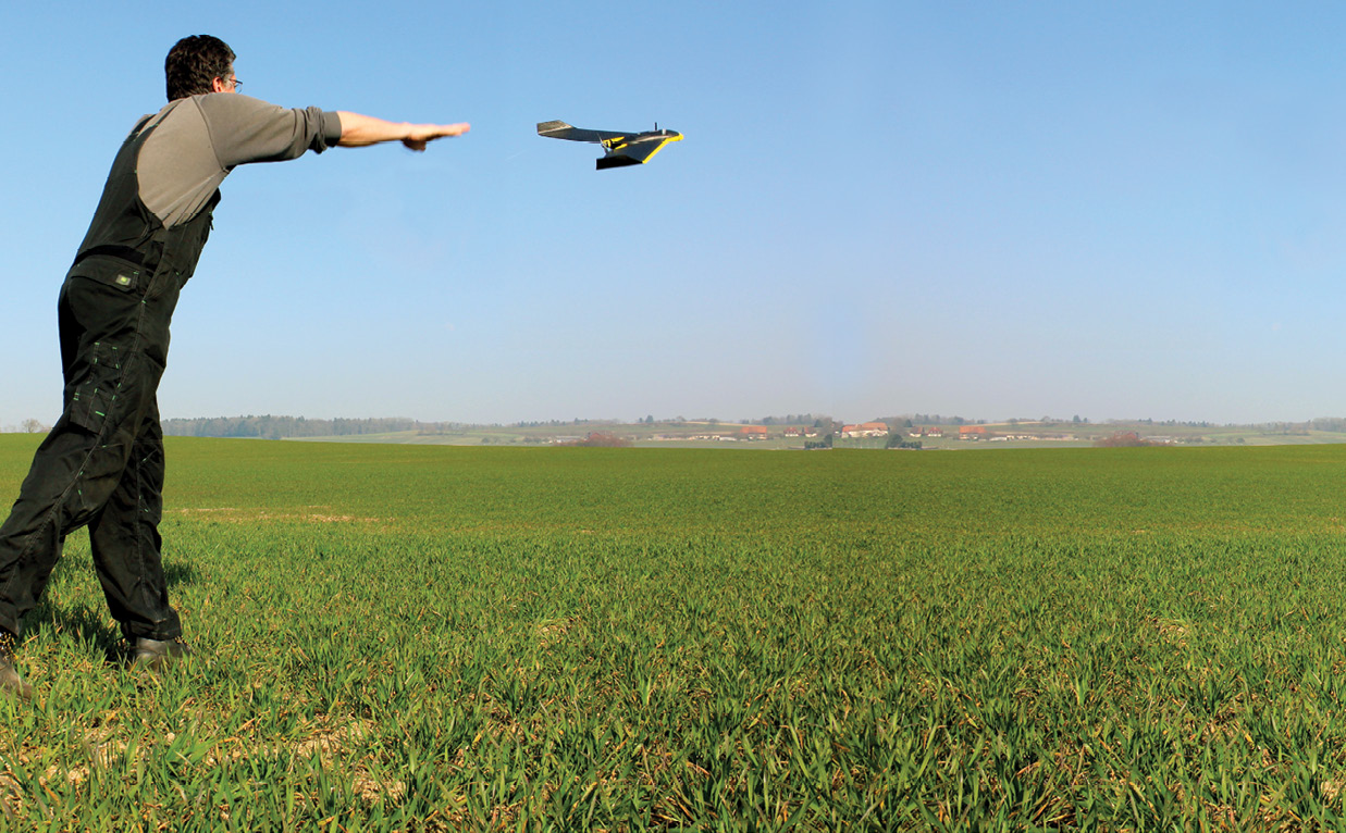
To meet its goals Empire will rely on the eBee Ag, a fixed-wing system built by the Swiss company senseFly. The 1.5 lb., hand-launched aircraft is fully automated with an autopilot that executes flight plans input by the operator.
“There is no need to learn how to fly and there’s no need for technical drone knowledge,” said Matthew Wade, senseFly’s marketing and communications manager.
“It’s a full package, a full-meal deal,” said Robert Blair of Blair Farms. “It’s not supersized by any means, but it’s a great place to start.”
At least four other firms appear to agree. According to their waiver applications they intend to fly versions of the eBee.
The vehicle comes equipped with a near-infrared sensor. It is also possible to get a red edge sensor and a RGB (red green blue) sensor, which provides the sort of pictures seen from a regular camera. The red edge sensor captures data in the band of frequencies where a plant’s reflectance changes from low to high.
“Each plant reflects light differently,” explained Blair. “One of the key elements reflectance maps can help us with is determining zones farmers can manage for nutrient purposes—for nitrogen fertilizer.”
SenseFly introduced a new thermal sensor in January. The device will enable users to capture thermal video and still images from which they can create thermal maps to chart water distribution, check irrigation systems or assess the functionality of solar panels.
One of the reasons his team chose the eBee Ag, Blair told Inside Unmanned Systems, is that its capabilities were well-documented globally and therefore they felt it had a better chance to win FAA approval.
“There are other systems out there,” explained Blair, “but it probably would’ve taken a little bit longer to get clearance.”
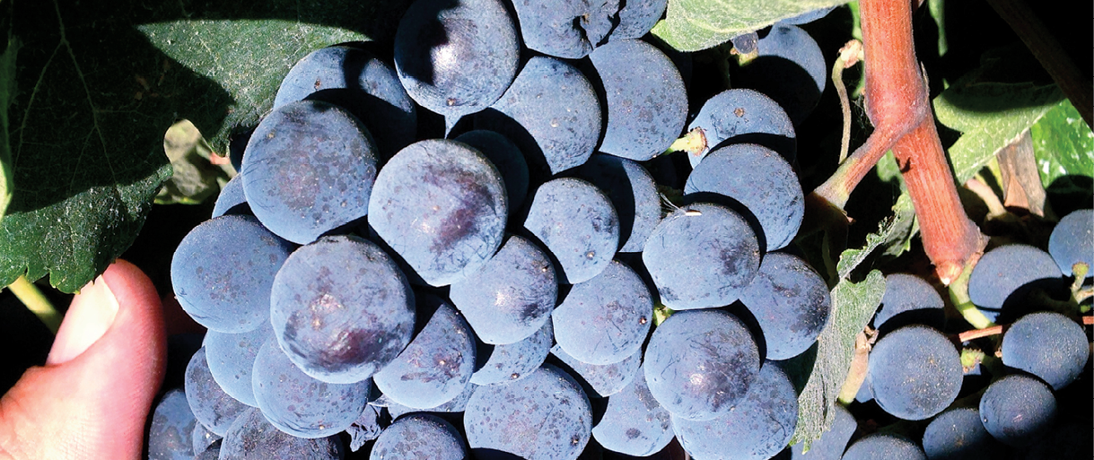
Data from a near-infrared sensor on a UAS can help vintners determine when to harvest grapes. Photo courtesy of Vine Rangers
Drone Ranger
Another company that plans to offer one-stop sensing and data analysis is California-based Vine Rangers, which plans to focus on specialty crops, particularly wine grapes.
Vine Rangers interviewed farmers and winemakers to find out what they needed, said CEO David Baeza, and then settled on the 3D Robotics RTF X8 multi-rotor to take near-infrared and thermal images.
“The most common things they were looking for were disease types, which are things like leaf roll, powdery mildew, mealybugs and things like that,” Baeza told Inside Unmanned Systems, noting that the firm’s sensors can spot all three.
The vintners, he said, wanted to be able to better estimate yields, identify water saturation and assess vigor. They also wanted to know if the vines are growing too fast, which drives the sugar from the grapes.
“They want to know about that early,” said Baeza.
Farmers are even looking at temperatures across a vineyard because certain varietals prefer warmer or colder microclimates, explained Baeza.
“If we fly enough times they can see there is a 10 degree or 15 degree difference between this spot on 100 acres and this spot.” If they have not planted yet they can take advantage of that to support different varieties of grapes, he said.
Finally, winemakers wanted to know when, exactly when, to harvest.
Right now they have to figure out the ripeness of the fruit by tasting random samples, said Baeza. It is possible, however, to estimate the Brix level, that is the sugar content of the grapes, using a near-infrared sensor.
“What it looks at is how much light passes through the fruit or reflects from the fruit,” explained Baeza. “So the softer the meat, and the softer the skin the more light it absorbs. Pretty simple. The harder the skin, the harder the meat the more reflective the berry is. From that you can figure out if the cluster’s 100 percent ripe.”
Vine Rangers co-founder Ashu Natraj, an expert in robotics and computer vision, suggested the choice of sensors. Vine Rangers also has the algorithms in place to process the data.
The winemakers want an analysis on a weekly basis, Baeza said, adding that his firm can turn around data in 24 to 48 hours. Perhaps more important, all the data is archived, he added, enabling farmers to look back and assess the outcome of different decisions.
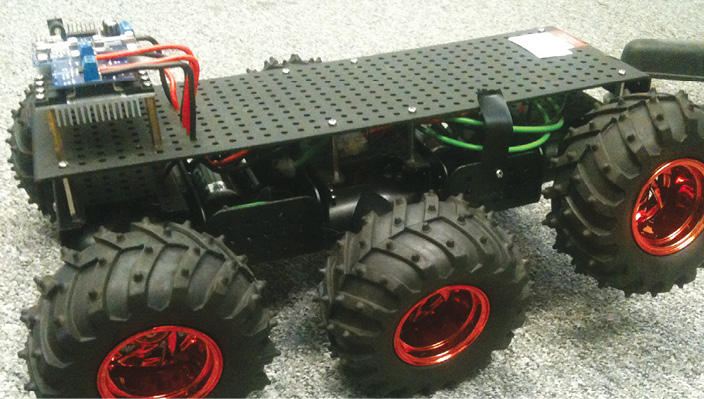
The platform for an automated ground system being developed to detect infestations. Photo courtesy of Vine Rangers
Getting Rolling
In addition to its aircraft Vine Rangers is experimenting with an automated ground system designed to detect mealybugs. These pests attack the rootstock or trunk of grape vines, an area that can’t be seen with a drone once the canopy of leaves has filled in.
The small six-wheeled vehicle “drives up and down the rows using the same or similar technology that you would use for aerial drones,” said Baeza. “It shoots a similar image but it is just pointing up at the canopy and at the root stock instead of pointing down.”
Vine Rangers is not the only one working on ground systems for agriculture.
The Swiss agribusiness firm Syngenta is in the early stages of developing a precision weeder.
“We are investigating various types of sensors and various types of control mechanisms,” said Derek Cornes, the firm’s lead for integrated weed management technology. “We hope to define the best approach during the project.”
Though the weeder is not specifically designed for unmanned vehicles, it could be used on them,” Cornes said in an email.
Research is also underway on a tethered aerial platform that can help farmers protect wildlife.
“It can be a bit upsetting for the driver and everybody else if you’re driving along harvesting your grass, long grass or something like that, and you’re killing animals,” said Simon Blackmore, the head of engineering at Harper Adams University in the United Kingdom.
With its tether, the aerial system remains largely stationary relative to the harvester. It uses a thermal camera to locate wild creatures in harm’s way.
“So nesting birds and young deer and rabbits and so on—all animals that you want to be careful of—with thermal cameras you’ve got an opportunity to sense that,” said Blackmore. “Whether you can react fast enough, at least you got a choice, an opportunity to do something about it.”
There are also opportunities for advances using proximal sensing, that is combining data from sensors on the ground with that from aerial systems, according to Melba M. Crawford, associate dean of engineering for research at Purdue University in West Lafayette, Ind.
“They are putting all kinds of sensors on cultivators, on planters, on combines,” Crawford told Inside Unmanned Systems. “There’s just a lot more going on. Pulling all that data together is going to be where it goes in the longer term.”
Better processing technology will be needed, however, before airborne systems will be able to guide automated ground vehicles effectively.
“We don’t have enough automation in the processing to know what to tell the ground systems from the air systems to make them do very useful things, said Moorhead. “We usually keep the human in the loop.”
“It’s just that time lag in data processing and prescription development that’s really the technological limitation right now, said Burger, “but I think that’s certainly coming.”