Museum of London Archaeology
Unmanned aircraft are changing the way we do things in countless industrial and academic sectors. In archaeology, where the name of the game is finding the hard-to-find, drone-based imaging has become a go-to technology, able to meet a range of user needs with limited investment.
“The unmanned drone system is now an important tool for us,” said Alison Dickens, manager of the Cambridge Archaeological Unit (CUA) within the University of Cambridge. “Drones provide key surveying capabilities and point the way to new excavation sites.”
Recent digs by CUA include the excavation at Must Farm in Cambridgeshire, dubbed the ‘British Pompeii’ because of its well-preserved Bronze Age dwellings.
“The drone is especially useful before we begin digging,” Dickens said, “giving us a wider view of an entire site, helping us to identify possible areas of interest—essentially seeing things that we cannot see clearly from ground level.”
While Dickens stresses the pre-excavation utility of drones, others are using them right through the excavation process.
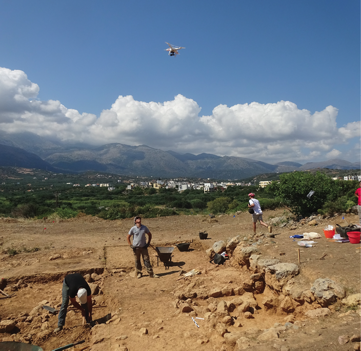
“We now use a drone on a daily basis for rapid, low-altitude, vertical shots, which we rectify and use for mapping archaeological remains,” said professor Jan Driessen of the Catholic University of Louvain in Belgium.
Driessen, who is director of the Sissi excavations (www.sarpedon.be) on the island of Crete and co-director of the Pyla-Kokkinokremos excavations on Cyprus, as well as director of the Belgian School at Athens, said they were getting general views, with their drone, but also interesting oblique shots, close-ups and wide angles. They are using a DJI Phantom 2, which he said does the job quite admirably.
When drones first started appearing in numbers, Driessen said, his colleague Joachim Bretschneider, a professor of Near Eastern Archaeology at the Department of Archaeology at the University of Ghent, acquired one of the machines. They now use it jointly in their different excavations in Crete and Cyprus.
“I have been researching Minoan and Bronze-Age archaeology in Crete since 1981,” said Driessen. “All through the 80s and 90s and up until 2011, we used balloons and kites with cameras for aerial photography.”
The Phantom 2, then the newest in the Phantom series, was quite an impressive platform when it first appeared in his workplace, he said.
Jan Dreissen, Catholic University of Louvain
“It is ready-to-fly and very quick to use—you just insert the battery; you don’t have to mount or dismantle the drone each time. It is light and easy to transport; it’s very safe; and it is also rather small and discrete, so it doesn’t scare potential visitors.”
Driessen said the equipment is not necessarily cheaper than balloons and kites, but once you have a drone system up and running, operating costs are negligible, and there is a significant improvement in terms of flight capabilities.
“You can fly in almost all weather circumstances, while a kite needs just the right wind, and a balloon doesn’t want any wind at all.” And, unlike balloons and kites, a drone is untethered, so it can reach the less accessible places, inside caves or buildings, in wooded areas. “The only limits are battery life and the number of pictures you can shoot,” Driessen said.
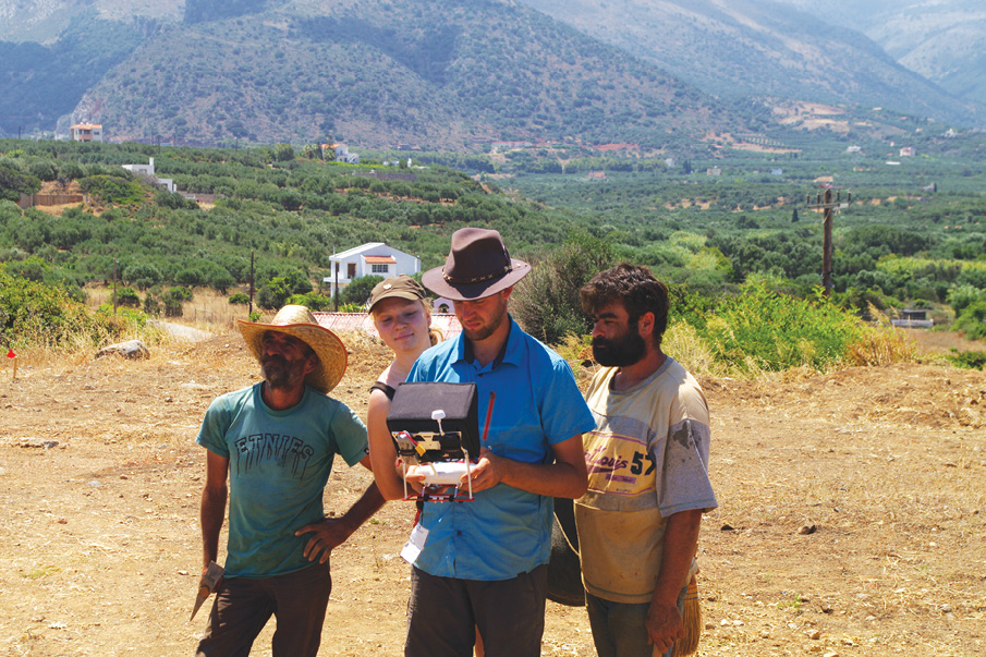
Piloting the drone for Driessen and colleagues is Nicolas Kress, who is both an archaeologist and topographer—as well, Driessen said, as a very handy and practical guy.
“Nicolas has acquired all of his drone hours on the job” said Driessen, “with no formal training. He has self-learned take-offs, taking pictures and landing, as well as photographic image processing.”
Safety of course remains a bottom-line issue. Driessen said one needs to respect certain drone-specific rules such as flight altitude, keeping people at a distance, keeping an eye on the drone at all times…but, he said, none of these rules are handicapping.
“Legislation regarding drone flight is in permanent flux, partly because lawmakers and regulators are having a tough time keeping pace with the technological advances and the ‘democratization’ of drones resulting from falling prices,” he said.
“We are registered with the relevant Civil Aviation Authorities and we introduce a request each time we want to fly. As we work in two different countries, Greece and Cyprus, we need to comply with different laws. And one of our sites in Cyprus is in fact within a British military base, which implies another set of regulations.”
Taking to the Hills
While some archaeologists such as those on Driessen’s team are mastering the art of drone flying themselves, other researchers are opting for a more hands-off approach, hiring service providers who do the drone work for them.
Consider the work at a large Welsh hillfort being undertaken by Oxford University researchers in association with the University of Wales and the University of Liverpool. The hillfort is located in the Clwydian Range in northeast Wales.
Around 2,500 years ago, the Deceangli tribe controlled the area and was probably responsible for the building of a string of forts, consisting of multiple lines of banked defenses and massive in-turned gateways.
Gary Lock, Oxford emeritus professor of archaeology, heads research on the hillfort.
“I’ve worked in archaeology for 35 years,” he said. “I first heard about drones being used in archaeological fieldwork at the Computer Applications in Archaeology conference, perhaps six or seven years ago.”
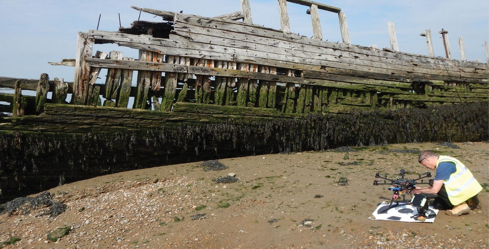
Undertaking drone-based work for Lock and his group has been Pete Rauxloh, the director of technology solutions at the Museum of London Archaeology (MOLA). MOLA is not actually a museum but a non-profit organization, once part of a museum, that now provides heritage- and conservation-related services to various clients, including drone-derived data collection and processing.
Jan Dreissen, Catholic University of Louvain
Rauxloh, who himself holds a PhD in archaeology, said MOLA was asked to fly a small unmanned aircraft over the hillfort site in August 2015 with the aim of capturing detailed two- and three- dimensional data over a wide area. This was to provide both baseline data for research and management purposes and an immersive representation of the monument.
The elongated shape of the site, some 800m long and 400m at its widest point, coupled with a strong wind blowing diagonally across it, required an clever flight plan to capture the imagery accurately, Rauxloh said.
“Since the aircraft must fly in a regular grid pattern, we needed to turn into the wind at the end of each leg. Equally, since the overlap between one image and the next image must be maintained around the magic 80% mark, and because that overlap is directly proportional to speed, we needed to keep a constant speed. We therefore flew across the wind, since flying directly into it would lead to great variation in speed on each leg of the survey.”
Nine ground control targets were laid out and their positions accurately recorded, and the flight was completed in about 30 minutes. The data was processed in Agisoft PhotoScan with the resultant detailed 2D orthomosaic and 3D model made available immediately to researchers via DroneLab (2D orthomosaic) and Sketchfab (3D model) web services (best viewed with the Chrome browser).
Rauxloh said MOLA uses DJI hexa and quad copters, and is currently considering Lehmann Aviation fixed wing aircraft for longer sorties. “Stability and affordability plus a broad user base are important, as is ease of use and good support from our suppliers.”
Because MOLA undertakes ‘aerial work’, i.e. for payment, the rules for them are different.
“We have carried out commercial work in the UK and research flights in Spain and Germany,” said Rauxloh. “Different Federal Aviation Authorities do have different rules, and some are more draconian than others. In the UK, for example, UK Aviation Law requires an organization such as ours to hold a Permission for Aerial Work (PFAW) to allow them to provide a commercial service to clients using small unmanned aircraft (SUAs).”
Rauxloh said MOLA works with EuroUSC, which is a company that helps groups like MOLA achieve compliance with complex CAA regulations for commercial service providers.
“Our Basic National UAS Certificate for Small Unmanned Aircraft (BNUC-S), which we obtain with the help of EuroUSC, is the preferred pilot qualification required by many national aviation authorities before a permission or exemption for aerial work may be granted,” Rauxloh explained.
“We currently have one qualified pilot at MOLA and two more in training,” he added. “This involves attendance at a ground school, familiarization with an operations manual, much flying practice and a flight exam.”
Future Trends
Rauxloh said future drones will feature improvements in battery and motor technologies, extending flight duration. He also anticipates increasing automation. “The BNUC-S pilot certification already has a class of flight exam standards suitable for SUAs (small unmanned aircraft) that follow a preplanned route immediately from launch, and that will recover and land themselves autonomously too.”
There will also be more advanced imaging technologies available for small drones. Back at the Welsh hillfort, Lock said the ability to generate 3D models and digital terrain models (DTMs) from vertical aerial photos was already extremely valuable, but his group is now hoping to undertake a more advanced survey using drone-mounted LiDAR, targeting an Iron-Age hillfort known as Badbury Camp.
Any number of sensor system types can theoretically be mounted on a drone for archaeological purposes, depending on weight and size. Dennis Menick, sales and marketing director at Switzerland’s SwissDrones, said tests have been carried out using the SIR3000 3D ground penetrating radar system made by Geophysical Survey Systems, Inc., a traditionally ground-based measuring device, in combination with a vertical take-off and landing UAV.
Mounting a handheld device such as the SIR3000 onto a drone implies several things: human physical effort is reduced during the actual survey; operators don’t have to move the device across the ground themselves; irregular terrain can be more easily scanned from a short distance above the ground; flight paths can be programmed and executed automatically; and, from a slightly higher altitude, the scanning device can cover a wider area in a single sweep.
Hyperspectral imaging systems are of particular interest to archaeologists. The UK research project ‘DART’ was among the first to demonstrate the use of space- and air-based hyper-spectral imaging in archaeological surveying, and now companies such as BaySpec, with its OCI-UAV, are marketing hyperspectral cameras designed specifically for use on UAV/UAS or remotely operated vehicles.
Making the (Business) Case
“The lowering cost barrier to entry is generating some bad press for the drone services industry,” Rauxloh said. In particular, he said, people are asking why we need drone service providers at all when just about anyone can buy a drone for him- or herself and use it to take pictures?
“The simple capturing of data per se is not going to remain a sustainable model”, Rauxloh said. “Rather, it is going to be added-value services that will swing contracts.”
Rauxloh accepts that many academic researchers probably already know what they are looking for and what they have when they find it. Jan’s Driessen’s group in Cyprus and Crete is a good example. They use their drone for traditional photographic imaging and that’s all they need, and they seem perfectly able to get along without the services of someone like MOLA. Others like Gary Lock, working on his hillfort survey, will want a more complex set of data, requiring more involved data-collection techniques, and perhaps more advanced sensing technologies.
Outside of the purely academic arena, what about people working in urban construction, who are not archaeologists but who, particularly in Europe, may be required to undertake an archaeological survey before they can break ground in a potentially sensitive area? They can go out and buy a drone too, and learn how to fly it. But will they know what to look for when it comes to their ground survey?
“At MOLA, we can fly drones, but, increasingly, so can anyone else,” said Rauxloh. Therefore, he said, in the future, the business model is going to be less about ‘we can fly drones’, and more about ‘we know what to do with the data’.
“In our case we have skills in the post-survey manipulation of 2- and 3D data sets within GIS and CAD systems,” he said, “exploiting the raw deliverables to derive new diagnostic products.
“But perhaps even more important than this is having an expertise with respect to the thing being surveyed. So again, in our case it is our specialization as heritage professionals that allows us to understand, interpret and advise clients and research partners. This I think gives our aerial service its edge and I hope will ensure its longevity.”