From advanced unmanned surface vessels (USVs) to cutting-edge synthetic aperture sonar (SAS) systems, maritime robotics is rapidly advancing offshore energy asset inspections, environmental monitoring and hydrographic surveying.
The maritime industry is experiencing a transformative shift as unmanned surface vessels (USVs) and advanced subsea inspection technologies redefine offshore operations.
The adoption of USVs is expanding across various applications, including structural inspections and integrity assessments of offshore oil and gas facilities, as well as inspections and mapping for a multitude of other sectors. These vehicles often operate in tandem with electronically powered and remotely operated vehicles (ROVs), providing comprehensive inspection capabilities.
Here, we delve into recent case studies and new solution offerings that illustrate how this work is shaping the future of maritime and subsea inspections, providing customers with innovative solutions that enhance efficiency, reduce costs and improve safety.
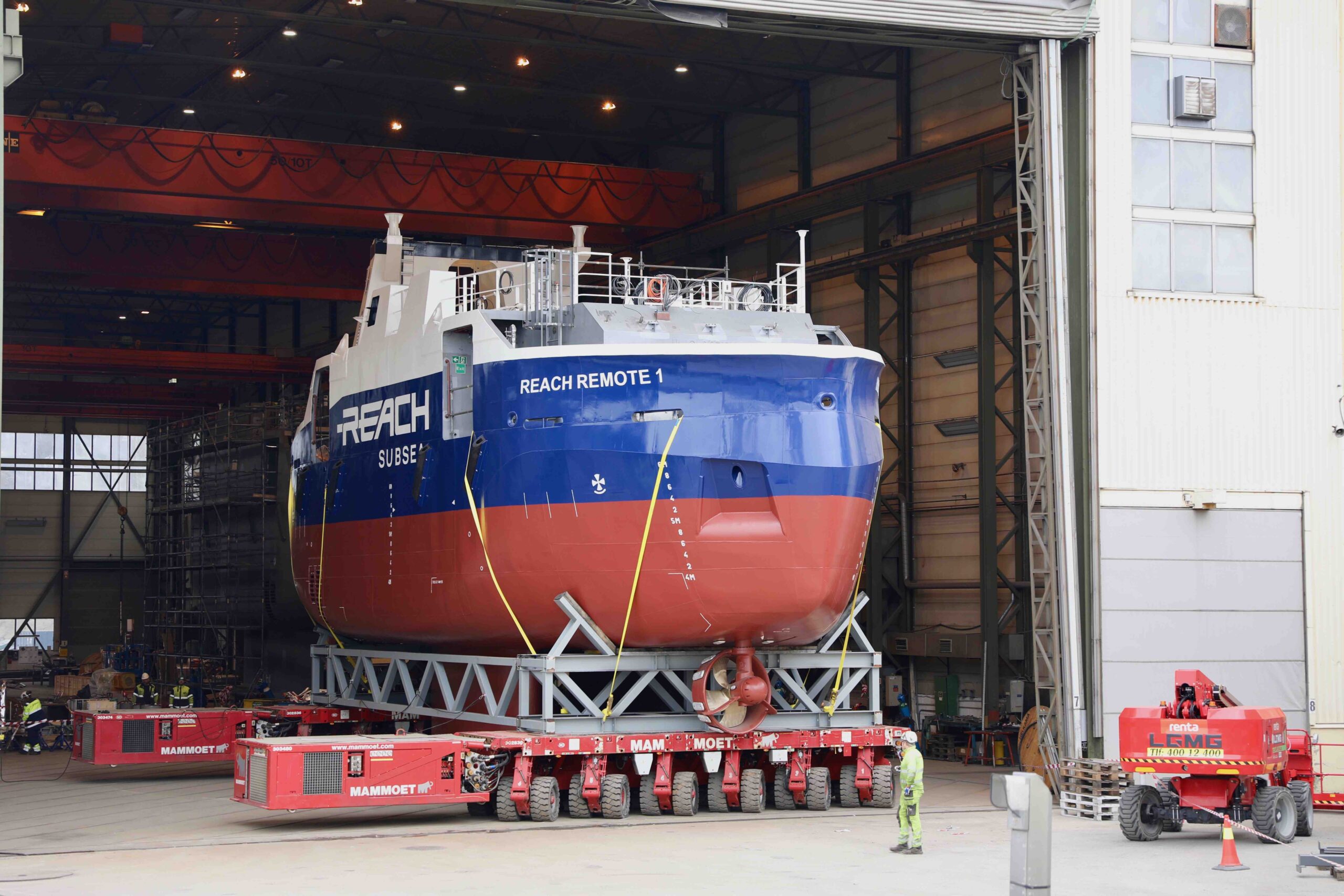
REVOLUTIONIZING OFFSHORE OPERATIONS: THE REACH REMOTE USV/ROV PLATFORM
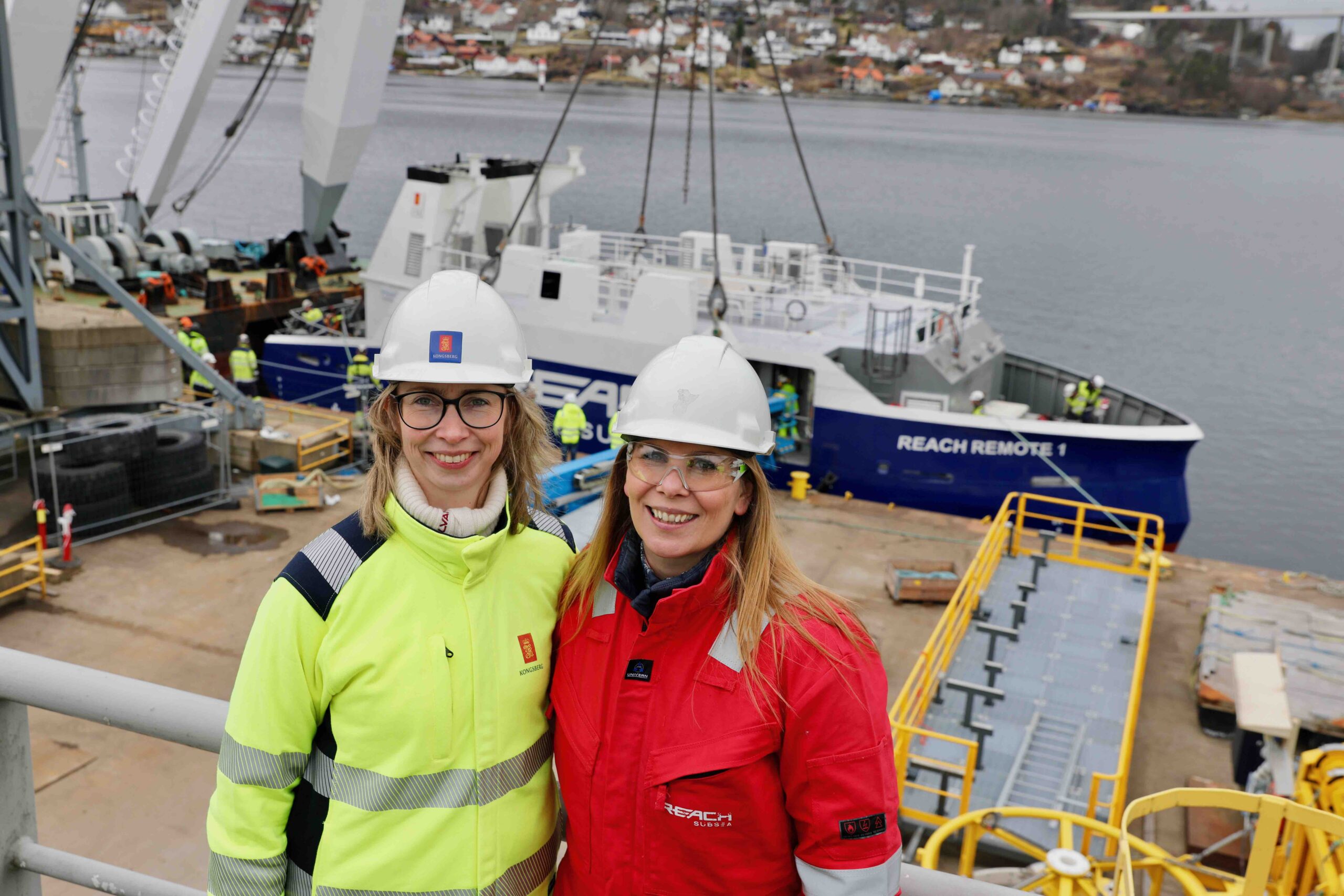
Kongsberg Maritime has delivered the first of its REACH REMOTE USVs to Norway’s Reach Subsea. The 24-meter vessel, named REACH REMOTE 1, is equipped with advanced Kongsberg technology and is designed to operate without an onboard crew, being controlled remotely from a land-based Remote Operations Centre (ROC) in Horten, Norway. This innovative approach offers substantial benefits in terms of operational costs, safety and environmental impact, including a targeted 90% reduction in emissions compared to traditional crewed vessels.
Inside Unmanned Systems met with Bjørg Mathisen Døving from Reach Subsea as well as Marthe Kristine Sand and Erik Leenders from Kongsberg Maritime, exploring the groundbreaking REACH REMOTE initiative.
THE GENESIS OF REACH REMOTE
Døving, VP of the REACH REMOTE initiative, provided the background on Reach Subsea’s interest in this project. “Traditionally, we charter conventional, and much larger vessels to deploy ROVs for various offshore projects. However, the offshore industry is highly volatile, with seasonal fluctuations and weather constraints impacting operations. We wanted to introduce a more competitive and cost-effective approach to subsea robotics. The idea of smaller, highly autonomous surface vessels to support ROV operations was a natural progression.”
Kongsberg Maritime had been exploring similar concepts, and their collaboration with Reach Subsea led to a dedicated research initiative. “We conducted pilot tests with small models and refined the technical design,” Døving continued. “Eventually, we reached a phase where we finalized specifications and entered full-scale production. The timing was perfect, given the increasing market demand for medium-sized USVs capable of deep-sea operations.”
KEY FEATURES AND CAPABILITIES
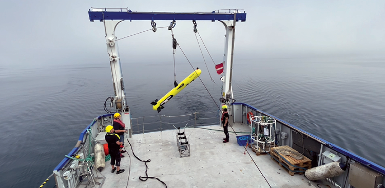
REACH REMOTE 1 is designed around a moonpool launch-and-recovery system (LARS) for her work-class ROV, allowing for safe deployment and retrieval in harsh conditions. The vessel is equipped with hull-mounted survey sensors, including the EM 2040 multi-beam echo sounder and a sub-bottom profiler, giving it the ability to collect high-resolution ocean data at depths down to 500 meters. The onboard ROV, which has a 1,000 meter umbilical, expands these capabilities further, integrating multi-beam sonar, side-scan sonar, and intervention tools for pipeline inspections, structure monitoring, and seabed mapping.
Sand, Kongsberg Maritime’s senior project manager, emphasized the project’s significance. “This is a true step-change in offshore operations. Instead of relying on larger, crewed vessels, we now have a highly efficient platform that reduces costs, improves safety and enhances data acquisition.”
Leenders, who designed the REACH REMOTE USV and is a naval architect at Kongsberg Maritime, added: “The vessel itself is a power and communication station for the ROV. It has an engine room with two generators, batteries, thrusters for transit and station keeping—all controlled from shore.”
AUTONOMY AND REMOTE OPERATIONS
The vessels will be controlled from a shore-based ROC managed by Massterly, a joint venture between Kongsberg Maritime and Wilhelmsen. “The ROC allows us to operate multiple vessels simultaneously,” Sand explained. “While we are starting with one support vessel in the initial phases, our long-term goal is full autonomy.”
Leenders elaborated on the communication infrastructure. “REACH REMOTE 1 features multiple layers of connectivity, including Starlink, VSAT, 4G/5G and emergency Iridium systems. If one link fails, it automatically switches to another. We also use a proximity view system that provides 360-degree situational awareness with automated object detection.”
Leenders added, “Autonomy is key, but we’re leveraging Kongsberg’s extensive experience in automation to ensure a gradual transition from remote control to autonomous operations. The vessel’s power management, propulsion and station keeping systems are integrated seamlessly.”
INSPECTION AND MAPPING USE CASES
Døving highlighted the vessel’s primary functions: “The REACH REMOTE vessels are built for subsea inspection and mapping. They can perform full-scale pipeline inspections, seabed surveys, and structural monitoring. The ROVs can conduct detailed visual inspections, side-scan sonar imaging, and even maintenance tasks like cleaning subsea infrastructure.” Leenders added: “The integration of multi-beam sonar and sub-bottom profilers allows us to build highly accurate seabed maps. These are essential for offshore wind development, pipeline route planning, and environmental monitoring.” Sand noted the efficiency advantages. “By keeping the operations remote, we can provide near-real-time data to clients, significantly reducing turnaround times for critical mapping and inspection operations.”
OPERATIONAL ADVANTAGES AND ESG IMPACT
One of the significant advantages of this approach is safety. “These vessels can operate in extreme environments without putting human lives at risk,” Døving noted. “They also reduce greenhouse gas emissions, thanks to their hybrid diesel-electric propulsion system.”
The reduced need for offshore staffing brings additional benefits, including easier logistics, reduced travel requirements and expanded opportunities for a more diverse workforce. “This technology allows us to open up offshore operations to a broader range of talent, including individuals who may not have been able to commit to long-duration offshore deployments,” Døving pointed out.
ADVANCED DATA MANAGEMENT AND CLIENT INTEGRATION
REACH REMOTE’s in-house developed data acquisition platform ensures rapid and high-quality data delivery to clients. “We’ve built a centralized digital platform that allows clients to monitor operations in real time,” Døving said. “Through our Reach Horizon, clients can track survey progress, review preliminary data and make informed decisions faster than ever before.”
The system prioritizes different data streams based on operational needs. “During vessel navigation, critical control data takes precedence,” Leenders explained. “Once the ROV is deployed, its control data becomes the highest priority. This dynamic prioritization ensures smooth and reliable operations.”
FUTURE PROSPECTS AND INDUSTRY IMPACT
The successful launch of REACH REMOTE 1 points to the beginning of a new era in offshore subsea operations. “This is a pioneering Norwegian export opportunity,” Døving said. “Kongsberg and Reach Subsea have developed a globally scalable solution that will transform the industry. We expect to see increased international demand for this technology.”
Sand agreed, adding, “Nothing on this scale has been attempted before. We believe this project will redefine how offshore surveys and inspections are conducted worldwide.”
As the offshore industry increasingly embraces unmanned and autonomous solutions, REACH REMOTE stands at the forefront of this revolution, promising safer, more efficient, and more sustainable subsea operations.”
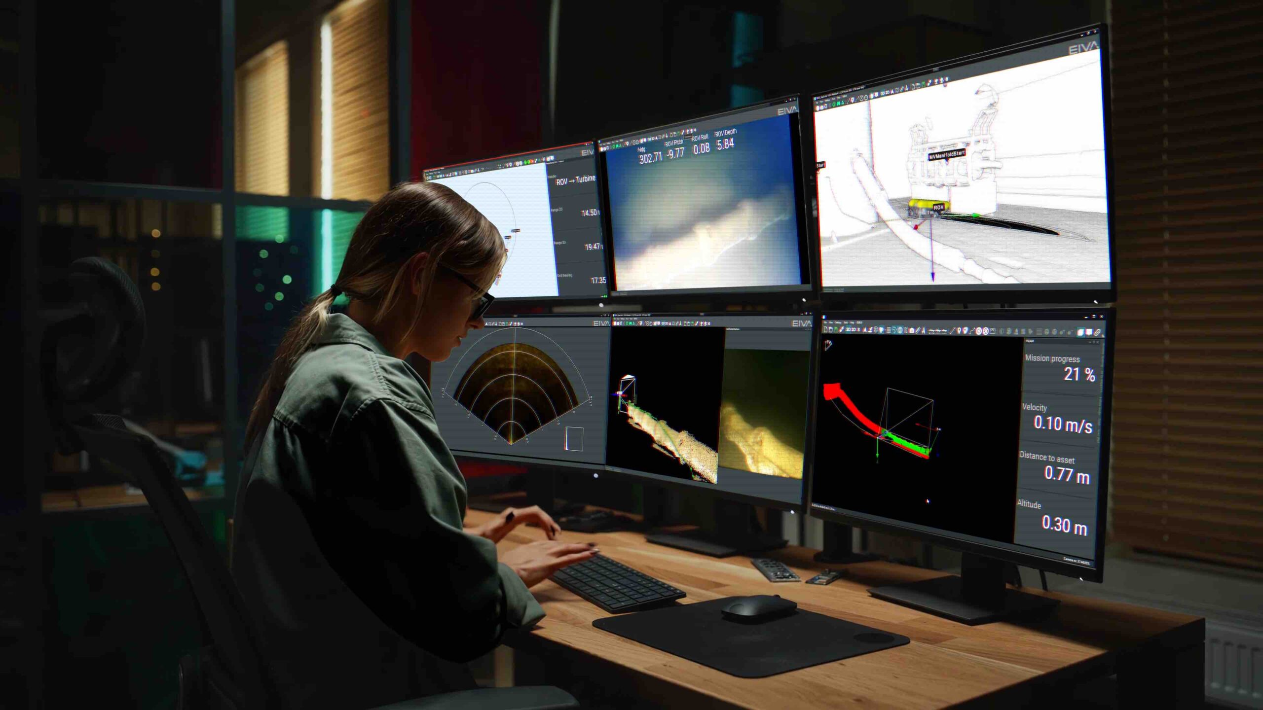
EIVA’S VISION FOR AUTONOMOUS SUBSEA INSPECTIONS
As the maritime industry accelerates toward greater autonomy, EIVA stands at the forefront, integrating cutting-edge technology with decades of expertise in subsea surveying. Inside Unmanned Systems met with EIVA CEO Christian Thomsen to discuss how the company is pioneering a new era of autonomous subsea inspections, leveraging precision engineering, real-time data processing and flexible software solutions to enhance efficiency and accuracy.
THE EVOLUTION OF EIVA’S AUTONOMOUS SUBSEA SOLUTIONS
With a rich history in subsea mapping and a deep understanding of offshore operations, EIVA has consistently innovated in positioning, sensor integration and data analysis. Thomsen described how the company’s journey has been shaped by both customer needs and industry trends. “Our goal has always been to provide the best tools for the job—whether that means designing our own technology or integrating with best-in-class systems,” he said.
One of EIVA’s most recent breakthroughs is its collaboration with Tuco Marine, which brings together an USV with EIVA’s sophisticated towed vehicle for real-time, high-resolution subsea surveys. “We saw an opportunity to combine proven vehicle designs with our expertise in autonomous navigation and sensor fusion,” Thomsen explained. “The result is a system that can conduct detailed inspections of critical infrastructure with minimal human intervention.”
CUTTING-EDGE SENSOR INTEGRATION AND DATA PROCESSING
EIVA’s approach to subsea inspections is built on precision and adaptability. The company’s ScanFish and ViperFish remotely operated towed vehicles (ROTVs) feature a suite of advanced sensors designed for maximum coverage and accuracy, such as:
• Sonardyne Inertial Navigation Unit: High-precision positioning accurate to within centimeters.
• Solstice Multi-Aperture Sidescan Sonar from Wavefront Systems: Delivers superior image resolution across a 100-meter swath, overcoming the limitations of traditional side-scan sonar.
• R2Sonic Multi-Beam Echosounder: Provides real-time bathymetric data.
• HyperMag Magnetometer from OFG: Detects magnetic anomalies for mine countermeasures and infrastructure assessments.
“What makes our system unique is how these sensors work together,” Thomsen said. “Instead of mounting them externally, which increases the risk of damage, we’ve integrated them within the vehicle’s body, making deployment and recovery significantly easier.”
A DATA-CENTRIC APPROACH: ENHANCING REAL-TIME DECISION MAKING
Thomsen highlighted EIVA’s emphasis on real-time data acquisition and processing, which enables more informed decision-making. “Traditionally, survey data has required extensive post-processing,” he noted. “We’ve streamlined that with real-time modeling and automated comparison tools.”
For example, EIVA’s software can overlay new survey data with historical datasets to detect changes instantly. “If an anchor has dragged across a pipeline or a mine-like object appears on the seabed, our system flags it immediately, allowing operators to take action,” Thomsen explained. “That kind of rapid insight is a game-changer.”
EIVA’s NaviSuite software suite also allows seamless integration with a variety of external platforms, reinforcing the company’s commitment to flexibility. “We don’t force our clients into a closed ecosystem,” Thomsen said. “Our software can integrate with a range of hardware and data management systems, ensuring that operators can use the best tools for their specific needs.”
SHAPING THE FUTURE OF SUBSEA AUTONOMY
As autonomy becomes a greater focus in offshore operations, EIVA is positioning itself as a leader in perception-based navigation and AI-driven guidance. Thomsen outlined the company’s long-term vision, which includes leveraging AI and real-time 3D modeling for fully autonomous subsea missions.
“We’re moving beyond just automating individual tasks,” he said. “The future is about creating truly autonomous systems that can understand their environment, adapt to dynamic conditions, and operate safely without human intervention.”
EIVA’s VSLAM technology, developed in collaboration with the optical sensor provider and EIVA sister company Voyis, is one step in that direction. “Voyis VSLAM Powered by EIVA NaviSuite is a real-time solution that generates 3D point clouds as the visual survey progresses, providing instant feedback on coverage,” Thomsen explained. “This ensures that no critical areas are missed, reducing the need for costly re-surveys.”
COLLABORATION, INTEGRATION AND AN OPEN APPROACH
Unlike some technology developers who push proprietary solutions, EIVA embraces an open and collaborative model. “We believe in best-of-breed solutions,” Thomsen said. “If a company already has an excellent perception system but needs better navigation, we can provide just that component. We don’t believe in forcing customers into a one-size-fits-all approach.”
This philosophy extends to partnerships with AUV and ROV manufacturers, ensuring EIVA’s technology can be deployed across multiple platforms. “We see ourselves as enablers,” Thomsen noted. “Whether you’re using our full stack or just a part of it, our focus is on making sure everything integrates seamlessly.”
EIVA’s solutions have been instrumental in advancing maritime survey and construction operations. A notable example is their collaboration with Brazilian startup TideWise, which sought to enhance their USV “Tupan” with advanced sensors to meet International Hydrographic Organization (IHO) S-44 Special Order requirements. By integrating EIVA’s NaviSuite Kuda software and renting a sensor payload, including a multi-beam echo sounder and LiDAR, TideWise successfully conducted sea trials, achieving precise multibeam echo sounder and LiDAR data collection. This partnership enabled TideWise to avoid substantial upfront investments while equipping their USV with high-end survey capabilities.
In another instance, EIVA’s ScanFish ROTVs are often used by GEOxyz to conduct efficient unexploded ordnance (UXO) surveys. By deploying ScanFish ROTVs in parallel, they increased survey efficiency and adaptability, ensuring maximum coverage—a critical factor given the rise of offshore wind energy systems and the associated need for thorough UXO surveys.
BRINGING AUTONOMY TO THE MASSES
One of EIVA’s core missions is making advanced subsea technology more accessible. “Many survey companies operate fleets with multiple types of ROVs and AUVs,” Thomsen said. “By standardizing our software across different platforms, we’re reducing training time and operational complexity.”
As subsea operations become more complex and data-driven, the company’s user-centric, flexible approach is helping to drive the industry forward, ensuring organizations have the tools they need to operate efficiently, safely and autonomously in the underwater domain.
HYDROSURV’S MISSION TO DEMOCRATIZE UNCREWED SURVEYING
HydroSurv’s entry into the uncrewed vessel industry was far from conventional. “We entered the uncrewed surface vessel space about six years ago,” David Hull, the founder and CEO explained. “Our story is different from most—we started as a shipbuilding and repair consultancy in 2012, providing vessel management and naval architecture services. Over time, we saw increasing interest in lean crewing solutions and vessel automation, which led us to pivot entirely into USV development.”
By 2018-2019, HydroSurv had transitioned fully into USV projects, with a vision to “democratize access to uncrewed surface vessel technology.” Hull described this as making high-quality, cost-effective technology accessible to sectors that traditionally lacked the resources to invest in such solutions. “At the time, ASV Global was a key player in the UK, but there wasn’t much else,” he recalled. “We saw an opportunity to create a company with end-to-end capability—from naval architecture and systems design to integration and software development.”
A UNIQUE BUSINESS MODEL: CO-OWNERSHIP AND LEASING
Unlike many USV manufacturers, HydroSurv doesn’t just sell vessels. “We offer multiple pathways for customers to access our technology,” Hull explained. “In addition to direct sales, we co-own vessels with clients, sharing the risk as they adopt uncrewed technology. We also offer leasing, which has been particularly popular for organizations needing to prove capabilities before making large capital investments.”
By adopting an operational expenditure (OPEX)-centric model, HydroSurv ensures its technology remains accessible and scalable. “Because we are the design authority on our USV systems, we can make leasing models economical,” Hull noted. “This flexibility has allowed us to build a strong customer base over the past six years.”
HYDROSURV’S USV LINEUP
HydroSurv has developed a range of USVs tailored to different operational needs. The company’s first product, the Reef 16, was a compact 1.6-meter USV designed to validate various payload configurations, including multi-beam, side-scan, and sub-bottom profilers. While this model was sold to another manufacturer in 2021, HydroSurv continued to expand its offerings.
Today, its core products include:
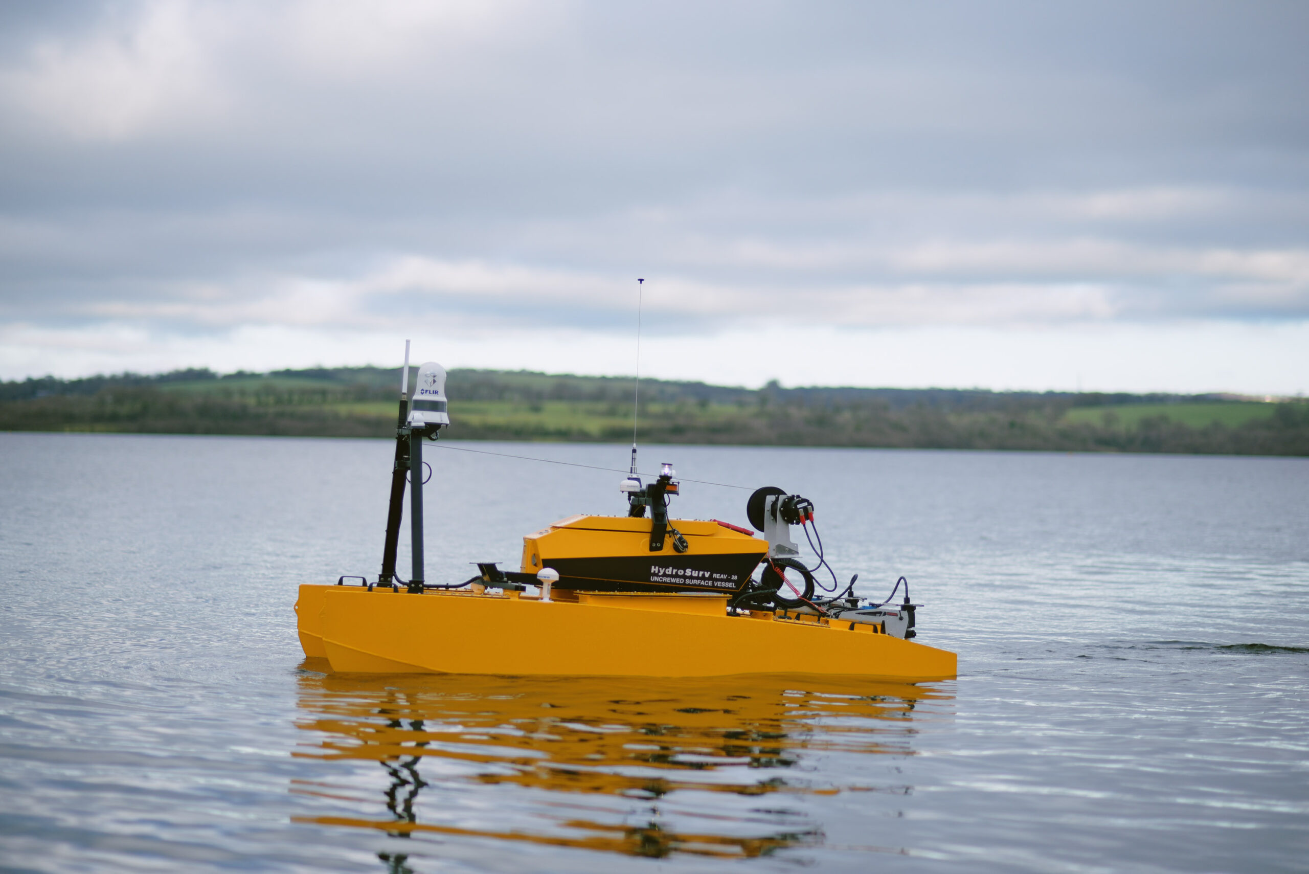
• Reef 28: A 2.8-meter modular catamaran with a battery-electric system and nine-hour endurance. It has gained traction in hydrographic and geophysical surveys, environmental monitoring, and oceanographic research.
• Reef 60: A six-meter sea-going USV with up to 10 days of operational endurance. It has been adopted by organizations like Sonardyne International for technology demonstrations and instrument calibration, as well as operators in the Baltics for survey and maritime security applications.
• Reef 47: A newly introduced 4.7-meter diesel-hybrid USV, designed to offer three-day endurance at a significantly lower price point than the Reef 60. “Customers were looking for a balance between capability and affordability,” Hull noted. “This vessel meets those needs.”
CLOUD-BASED DATA MANAGEMENT WITH EASYSURV
HydroSurv’s innovation extends beyond hardware to data management. “Back in 2020, we started developing our own cloud-based GIS platform called EasySurv,” Hull said. “The goal was to eliminate the need for expensive software licenses and specialized skills, making geospatial data accessible to commissioners and end-users.”
EasySurv includes unique features such as a difference modeling engine, which allows users to compare bathymetric survey datasets in real-time. Originally developed for dredging applications, the tool has expanded into environmental monitoring. “We’ve adapted it for seagrass monitoring and submerged aquatic vegetation studies,” Hull explained. “It enables researchers to measure seasonal and annual variations in vegetation cover, supporting blue carbon sequestration and biodiversity initiatives.”
The platform’s impact was recognized in 2021 when HydroSurv won an award from the UK Hydrographic Office’s Admiralty Marine Data Innovation Challenge. “What started as a survey tool has evolved into a broader environmental monitoring solution,” Hull said. “We’re also expanding into water quality monitoring, which is a growing focus in the UK.”
TRENDS IN AUTONOMOUS MARITIME TECHNOLOGY
Looking ahead, Hull sees rapid expansion in the USV market. “Over the past 18 months, we’ve seen a shift from customers asking for a single USV to asking for fleets of five over a three-year period,” he observed. “That tells us the industry is scaling, and operators are moving beyond trial phases into full implementation.”
Regulatory advancements are also driving adoption. “The UK has introduced clearer certification pathways for USVs,” Hull said. “Larger USVs can now be certified under the Workboat Code, and smaller vessels have relaxed technical requirements. This regulatory certainty makes it easier for customers to insure and integrate USVs into their fleets.”
HydroSurv remains committed to an open, collaborative approach. “We have a very open policy on partnerships,” Hull said. “We’re keen to work with research institutions, commercial operators, and system integrators across the maritime value chain.”
The company is also expanding its design and consultancy services. “We do a lot of design work for other USV manufacturers, including retrofitting control systems onto existing vessels,” Hull said. “That’s an exciting growth area for us.”
With a strong foundation in both technical innovation and flexible commercial models, HydroSurv is well-positioned to shape the future of uncrewed marine surveying. “As the industry moves from exploration to adoption, we’re excited to be at the forefront,” Hull concluded.
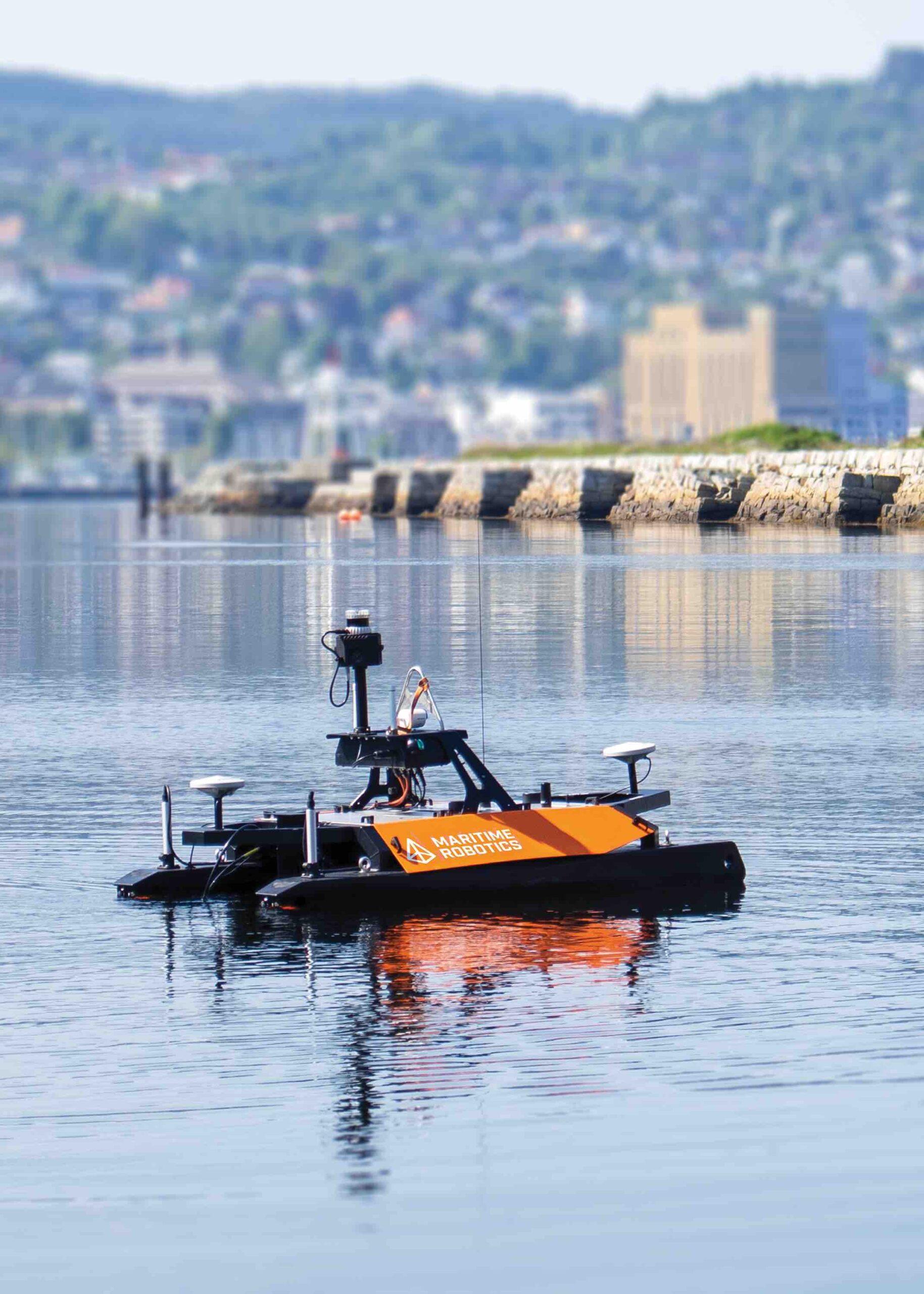
MARITIME ROBOTICS’ OTTER USV
The Otter USV, developed by Maritime Robotics, illustrates the growing demand for compact, high-precision hydrographic survey solutions. Designed for operations in sheltered waters such as lakes, rivers, harbors and nearshore environments, the Otter features a 2-meter catamaran hull, providing stability and a small operational footprint. Its electric propulsion system enables speeds of up to 6 knots, with an endurance of up to 20 hours at survey speeds, making it ideal for extended missions.
The system can be configured for both remote and fully autonomous operation, leveraging advanced navigation systems and multiple communication options, including 5GHz MIMO radio, Wi-Fi, and 4G connectivity. The Otter’s modular payload bay allows integration with high-resolution NORBIT WINGHEAD i77h multibeam sonar and iLiDAR systems, enabling precise bathymetric and LiDAR data acquisition.
A significant deployment of the Otter USV was for DEME, a provider of offshore dredging, environmental remediation and marine infrastructure. The system allowed DEME to collect real-time bathymetric data with minimal human intervention, improving operational efficiency and reducing the environmental impact of dredging projects. The UK Royal Navy’s Project Hecla evaluated the Otter Pro variant to enhance autonomous hydrographic capabilities. The trials demonstrated the Otter’s ability to collect high-resolution sonar imagery of underwater wrecks, contributing to seabed mapping, naval reconnaissance and infrastructure assessment.
Maritime Robotics has integrated open-source robotic control systems (OtterROS) to facilitate research applications, making the Otter an adaptable platform for scientific, defense and commercial maritime operations.
THE FUTURE OF MARITIME AND SUBSEA AUTONOMY
As the industry embraces these autonomous solutions, key challenges remain. Regulatory frameworks, data management and adoption by traditional maritime operators will dictate the speed of implementation. Companies leading this transition must balance technological innovation with operational reliability, cybersecurity concerns and integration into existing workflows.
Looking ahead, automation, AI-driven decision-making and real-time data analytics will continue to shape the next generation of maritime and subsea operations. As industry leaders refine these technologies, we can expect a future where fully autonomous, persistent maritime surveillance and inspection platforms become the norm. Adoption of autonomous maritime technologies is reshaping what’s possible beneath the surface.