“Drones are now a part of every industry. You name it—in construction, real estate, oil and gas, infrastructure, energy, renewable energy, all these sectors are opening their doors to drones,” Mohamed Shawky, cofounder and CEO of Dubai-based GIS Drones, told Inside Unmanned Systems. In the short time since starting his company in October 2020, Shawky said, “We have grown from zero to hero, and we can see even the government is now hiring people and creating new departments especially to facilitate drone operations.”
GIS Drones provides inspection and surveying services, holding commercial drone permissions in the United Arab Emirates (UAE), Saudi Arabia, Oman and Europe. Among the projects the company has carried out in the UAE is a high-accuracy topographic survey for bike paths in Dubai.
“Our Roads and Transport Authority [RTA], with the agreement of His Highness Sheikh Mohammed bin Rashid, the ruler of Dubai, wanted to make cycling available to everyone in the country,” Shawky said. “The vision was to have 53 kilometers of cycling track in three linked sections, including about half the length of Sheikh Zayed Road as it crosses the city, a long section of Jumeirah Street on the seafront, and the whole length of Dubai Canal, ending at the city’s historic Al Jaddaf district. All of the bike paths needed to be joined together, without any interruption for the riders.”
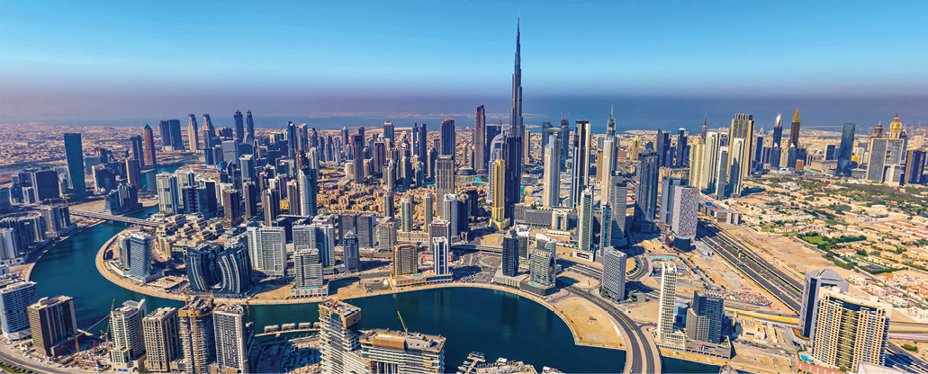
Dubai is a hotspot, literally and figuratively, fascinating and exotic, at once futuristic and centuries old, with skyscrapers, ports and beaches where people from all walks of life come to do business and have fun. Some of the RTA bike paths, the one’s along Sheikh Zayed road, take cyclists through the heart of the bustling city.
“This is a critical location, in some places actually running immediately under the elevated metro line,” Shawky said. “If you had to do this using manual surveying methods, it would be time consuming, it would be risky, and the accuracy would not be the same compared to our drone survey.
“The whole project took us only four days to capture,” Shawky said, “and two weeks to finalize the data processing and provide the final deliverables.” These included 2D maps, orthomosaics, contour lines, digital terrain models and digital surface models. “We provided all the engineering deliverables for the construction company to be able to build that cycle track,” Shawky said, “and, astonishingly, we provided an accuracy of about 2.5 centimeters.” GIS Drones employs a fleet of modern RTK-enabled survey drones with ground stations and uses Pix4D Mapper for post processing.
REACHING NEW HEIGHTS, INDOORS
In another project, GIS Drones carried out detailed inspections of elevator shafts in a high-rise hotel.
“We were called in by one of the best and most unique luxury hotels in downtown Dubai,” Shawky said, “located just across from Burj Khalifa,” the tallest building in the world. “The hotel had a problem with some unexpected gases or smells that were coming from the elevator shafts, and they wanted us to inspect the shafts internally, to see if we could identify what was causing the problem.”
The company that originally supplied the elevators had refused to do the inspection job, citing its inherent danger for their employees. “To get someone to have to physically climb inside and look at those elevator shafts, from top to bottom—there are six shafts altogether and the height of the tower is more than 60 floors—that’s a very high-risk job, but we thought we had the right tool to do it,” Shawky said.
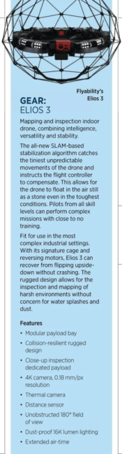
That tool is the Elios 3, a versatile indoor drone made by Swiss company Flyability. “Elios 3 works in confined and GPS-denied spaces and we use it equipped with very high-quality visual and thermal cameras,” Shawky said. “Plus, it has a powerful lighting system, so it can work in very dark locations.”
GIS Drones prepared a risk assessment, agreed on a methodology with the hotel and went to work. “We started flights at four o’clock in the morning, to be sure the tenants were asleep. Aside from the odd starting time, we carried out our operations as usual, flying for four hours a day. In four days we completed the job.”
Inside the elevator shafts, the Elios 3 spotted broken pipelines, cracks in floors and disconnected electrical wires. The owners were very happy to receive precise and actionable information about the condition of their building, and repair work was commenced immediately.
“Of course. we also do external inspection of towers,” Shawky said, “to detect all anomalies and defects that might appear visually on the exterior. We have an AI tool that can detect more than 30 types of defects—cracks, corrosion, rust, paint peeling, non-working solar panels, insulation issues, electricity, water leakages, all these issues can be detected.”
The UAE is known for its extraordinary modern architecture, with buildings of unusual shape, height and form. “With these irregular buildings,” Shawky said, “and using normal inspection methods with scaffolding, it can take you two to three months to do what we do with our drones in only one day. We recently detected 588 issues on one tower after just four hours of flight time. We delivered our report in two days. What we saw, among other things, were loose and cracked window panes, high above the ground. So, this job was potentially life saving, if we just imagine what might have happened if these glass panes had come off and fallen to the street below.”
MORE GROUNDWORK
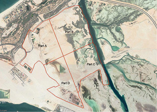
Saadiyat Island, in the city of Abu Dhabi, is known for its ponds, lakes and mangroves. “It’s a huge island [27,000 square kilometers], just off the mainland,” Shawky said. “The city’s vision is to convert Saadiyat Island, to make it a source of knowledge and tourism. There we have New York University Abu Dhabi, we have the Louvre Abu Dhabi Museum, and it’s going to be a very luxurious island.”
GIS Drones was called in to support an important infrastructure project. “The plan is to do some dredging in the uninhabited areas of the island, to dredge the water and ponds, lakes and mud, and to replace that with sand and concrete, to be ready for construction. Again, this would have been a risky job for a normal land survey. Some of the areas that need to be dredged are completely unreachable. People or cars would simply sink out there in dangerous sands or mud.”
Working in collaboration with the national energy company, GIS Drones deployed its team, surveying the island in four sections. “We did our topographic survey, with accuracy down to four centimeters, and we finished the whole island in five days.”
IT’S ALLOWED
Notwithstanding the obvious benefits of drones in terms of speed, efficiency and safety, their operations are still being held up in parts of the world by a lack of clear regulatory guidelines. For their part, UAE aviation authorities appear to be keeping pace with the technology.
“We have here general civil aviation and Dubai civil aviation,” Shawky said, “and our pilots need to be certified by both. This is our so-called RPAS certification, which allows us to fly anywhere in the UAE and the GCC [Gulf Cooperation Council] region.” For now, drone operations in the region still have to be piloted from within visual line of sight. “Usually, BVLOS is not yet allowed by regulations in the UAE,” said Shawky, “but there are exceptions.”
One such exception were operations carried out by GIS Drones during the recent New Year’s celebration, 2022 to 2023. “We were asked to do crowd surveillance,” Shawky said. “The Burj Khalifa fireworks display is of course world famous, and this year the city was expecting something like 600,000 spectators. We set up a system to operate our drones through remote control over 5G technology, via internet connection. This allowed us to avoid GPS denial, with Dubai, as you know, being full of skyscrapers. We deployed two drones BVLOS from 4 p.m. to 4 a.m., streaming high-definition video from critical locations to a central control room.
“There are some pilot projects for BVLOS, like in Silicon Oasis with the Dubai Foundation,” Shawky said, “to study the impact and the regulation required for BVLOS, for delivering food or medical equipment.”
Shawky said he sees the UAE trying to find the right regulatory balance. “The more drones are flying, the more risk, in terms of privacy and security, so there needs to be a balance. It shouldn’t be so strict that you can’t fly, but it shouldn’t be so open that we breach people’s safety and privacy.”
AS FAR AS COULD BE
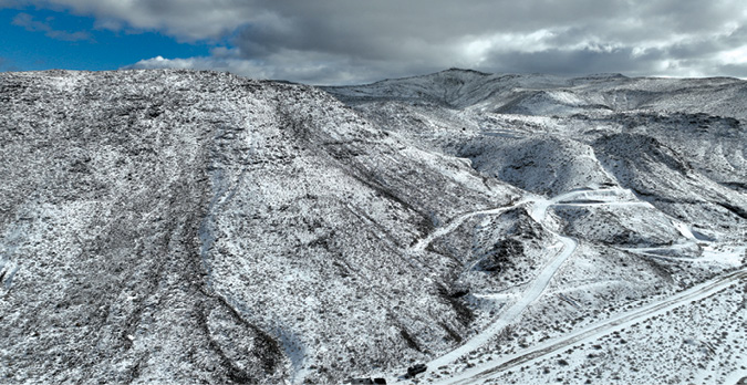
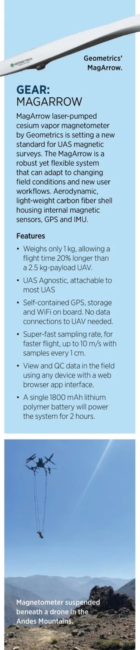
We fly away, from the shimmering sands and skyscrapers of Dubai and Abu Dhabi, to the other side of the world, to South America and the beautiful and terrible Andes Mountains. There too, drones have found important work to do.
“We just completed a project in South America, magnetic surveying high in the Andes,” said Marshall MacNabb, president and CEO of MWH Geo-Surveys. “The project was for mineral exploration and involved flying in very challenging terrain, with a vertical difference of over 1,800 meters across the span of the flight area.”
MWH Geo-Surveys, with offices in British Columbia, Canada, and Nevada, is a leader in UAV magnetics and orthophoto mapping. The company’s personnel have travelled to some of the most remote sites on Earth to provide high-quality gravity surveys for resource exploration clients. MacNabb said, “Typical clients for magnetic surveying are companies in the mineral exploration, petroleum exploration, or geothermal power sectors, and these make up the vast majority of our clients.
“We fly several different UAVs, depending on the payload, operating environment, and location,” MacNabb said. “Our current fleet consists of several ArcSky X55 heavy-lift UAVs, several Watts Innovation Prism axial quads, and several Wingtra One PPK mapping UAVs. Each of these is tailored to working reliably in difficult conditions.”
FINELY HONED PAYLOAD
Mineral exploration using geophysical magnetometers was an established practice well before the advent of drones, MacNabb said. “So-called ‘ground mag’ involves a surveyor walking with an instrument strapped to his back in straight lines across the terrain.” This enables the collection of high-resolution data, but it is a slow and expensive process and is limited by the nature of the terrain. “The other process is ‘air mag,’” he said, “where you survey from a manned aircraft.” This allows collection of data over large areas quickly, but you can’t achieve the same data resolution, and it comes with all of the burdens associated with manned aviation.”
MWH Geo-Surveys’ preferred magnetometer is the Mag Arrow by Geometrics, one of the first UAS-enabled magnetometers, engineered to overcome the limitations of ground mag and air mag surveys. “The way these instruments have evolved in recent years, they can now be mounted on drones,” MacNabb said. This enables both wide area coverage and collection of higher-resolution data, as drones can be flown closer to the ground and at slower speeds. “We have found this to be a very accurate magnetometer with great reliability in all conditions,” he said.
The Andes are known to be one of the greatest sources of mineral wealth in the world, with huge deposits of natural gas, coal, uranium, copper, iron, phosphates, silver, gold, mercury, zinc, lead, bauxite, molybdenum, nickel, petroleum, potash, and many more. For the magnetic survey project, deliverables included a high-resolution dataset and map of the local magnetic variations. “This is going to be very helpful for geologists and geophysicists to determine resource potential in this particular area,” MacNabb said, “and our methodology allows this kind of study to be done with very low impact to the local environment.”
EXPECT MORE OF THE SAME
To date, MWH Geo-Surveys has conducted more than 80,000 line kilometers of UAV magnetics surveying, including the first multi-sensor UAV surveys collecting both spectral and magnetic measurements. With operations in North America, South America, Asia, Africa and Europe, the company has produced orthophoto and DSM maps covering over 8,000 square kilometers.
“This is a growing market, as the geophysics industry begins to understand the value and impact of UAVs,” MacNabb said. “Areas that were considered too small for traditional airborne surveys, or areas requiring high-resolution data, can now be flown with UAV-borne sensors that have proven themselves.”
Here ends our two-stop tour of worldwide drone operations. In the UAE, on the Arabian Peninsula, as in the Andes Mountains of South America, and, rest assured, all points in between, drone service providers are coming forward with new tools and even more energy and enthusiasm, changing the way surveyors and inspectors of all kinds do their work, and their clients are only asking for more.