Creating a decentralized GNSS corrections network solves a lot of core issues for ROCK Robotic customers, including asset use. So when CEO Harrison Knoll heard about GEODNET, he knew he wanted to be involved.
GEODNET is a blockchain-based decentralized network of high-precision multi-band GNSS base stations, and offers a different, affordable approach to GNSS corrections that anyone can access. Project Manager Mike Horton got the idea to create this dense geospatial network after seeing another similar successful blockchain project, and it’s an idea that’s mostly been met with enthusiasm in the PNT industry since he introduced the idea at ION GNSS+ in 2021.
Officially launched in 2022, the network of Web3 GNSS base stations has grown to more than 3,000 globally, becoming a reliable solution for RTK applications. The goal is to have between 50,000 and 100,000 base stations by 2026. A technical introduction to GEODNET was published in the Journal of Navigation Winter 2023 issue.
The key, Horton said, is the fact GEODNET is decentralized. Station owners set up a Satellite Mining station and are rewarded in the project’s native Polygon token, GEOD. When new stations join the blockchain, they prove their location using a published algorithm. And the people who set them up are rewarded with tokens.
“It’s a good use of blockchain in the real world,” Horton said. “It’s not just people trading pictures back and forth, which is what a lot of people do with cryptocurrency. This is a way to efficiently and fairly finance an infrastructure that couldn’t be built in other ways.”
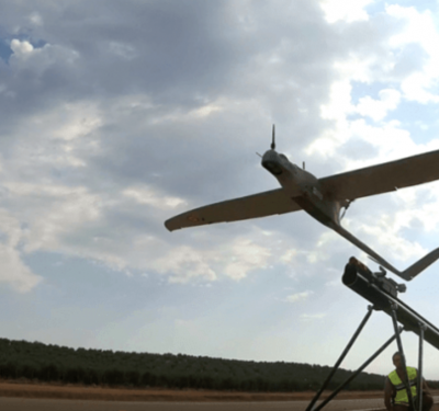
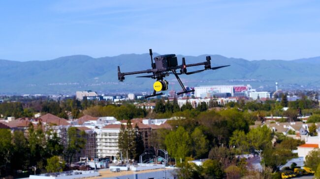
ROCK uses GEODNET as part of its LiDAR drone scanning solution, with customers ranging from land surveyors to drone survey providers to utilities. The company launched ROCK Base earlier this year, a miner that’s pre-qualified to earn GEOD tokens.
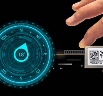
ROCK Base, a triple-band multi-constellation RTK/GNSS base station, gives customers access to the GEODNET base-station network to geo-reference ROCK Robotic’s 3D data products to millimeter-absolute position accuracy. And it does so without the cost and aggravation that comes with setting up ground control points. Knoll is in the process of reaching out to current customers, such as DOTS and municipalities, to get them set up on the RTK network.
ROCK Base tracks all major signals transmitted from GPS, GLONASS, Galileo, Beidou, QZSS, and the IRNSS navigation satellite constellations. It includes a survey-grade antennae, cables and the antennae-mounting equipment needed to set up a permanent Continuously Operating Reference Station (CORS).
The service gives users more control, Knoll said, and allows them to achieve centimeter level geolocation for photos collected via drone—and that’s becoming a big use case. They can put base stations right outside their office and get really accurate data, and don’t have to worry about government agencies or large corporations getting involved.
“Drone operators won’t ever need a base station again,” he said. “They can get RTK and PPK accurate data anywhere in the world just by stepping outside. They won’t need to lug around a second GNSS receiver; they can run it all through the network in real time or calculate in post processing. It’s big for drone surveyors and map makers.”
How it Works
Anyone who wants to be part of GEODNET can set up a station, use the network or build on top of the network, Horton said. It’s “a very open, flexible system,” with users trading tokens earned to access the data they need for their applications.
And because it’s all bound together by blockchain, there isn’t a company in control behind the scenes. It’s a true community approach, Horton said, with everything connected through a protocol that all systems adhere to. Users can add stations to areas that don’t have any or much coverage or tap into existing stations in their area with a subscription.
“The token is how people exchange value in the ecosystem, and that’s the part that’s radical,” Horton said. “But it’s a way to create independent operations and allow businesses to make use of GEODNET data by also contributing. It’s like a cycle. The more people put up stations, the more successful the network becomes, and the more people then want to put time and energy into the ecosystem.”
The token trades every day, Horton said, and offers an incentive for people to set up stations no matter where they live. As data from the network is paid for and used by end-users, this “burns up” mined tokens. Tokens are purchased back with cash and sent to a one-way safe on the blockchain. This buyback and burn mechanism is at the core of how the network functions economically.
It is important to keep in mind GEODNET is not really a company, Horton said, but a community. The non-profit GEODNET Foundation manages the open network protocol and promotes service use within the traditional GNSS and IoT industry. It “works to align the interest of the community of miners with the community of customers, with the goal of constantly improving the utility and value of the GEOD token.”
“We provide open access to data throughout the world for all applications that use corrections networks,” Horton said. “People set up stations at their home or office and then are rewarded for having that station online, depending on how good the quality is. It lets people participate in the network, setting up stations and then earning tokens they can sell on the crypto exchanges.”
The Need for Accuracy
Of course, the data provided from the GEODNET stations must be high-quality, Horton said, and it is. There are two tiers of stations: the backbone stations with greater than 99% reliability and the more affordable stations with a target of 98% reliability. And because there are so many stations, with the number continually growing, there’s also redundancy.
The signals are monitored for spoofing, Horton said, and each device has a unique ID so it’s easy to spot if someone sets up a station and tries to put fake GPS data into the network.
“Normally, if you set up a receiver you know it’s good,” Horton said. “Here, you have to trust others and need proof the stations are valid. We put a unique crypto chip in every station that identifies which device data is coming from.”
A Strong Start in Romania
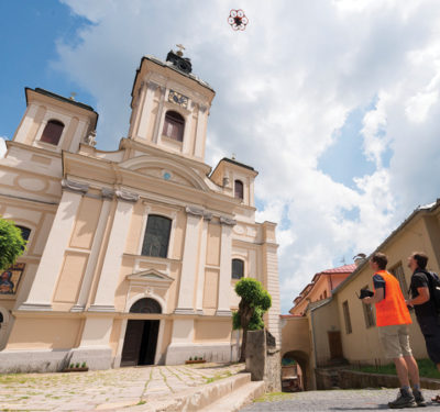
The GEODNET location service offers centimeter location accuracy for applications beyond drones, including robotic vehicles, agriculture, augmented reality, and IoT/mobile devices.
Some of the first base stations were set up in Romania, Horton said, and there are now more than 200 of them online in the country. Agriculture is one of the main industries benefiting from the service.
Before GEODNET, users in Romania mostly used one network, the Romanian position determination system (ROMPOS). ROMPOS is owned by the government and only has about 50 stations, said Marius Negreanu, one of the owners of Romania based distributor EuGeo. There are also a few stations set up by smaller companies, but they don’t have the density GEODNET provides. Some use these more expensive services as backups to ROMPOS, resulting in a more complicated solution.
Negreanu likes that GEODNET offers subscriptions to users anywhere in the world, and that you can use the same subscription no matter where you are.
Negreanu sells affordable autonomous tractor kits to farmers, he said, and is using the kits as a bridge to promote the network. An antenna that links to the closest GEODNET station is part of the kit that turns a manual tractor autonomous. This is something more farmers in Romania are becoming open to, as they realize the centimeter precision the kit provides leads to a larger harvest and less field consumption.
Negreanu recently worked with a client originally using a kit without a good GNSS network, so the accuracy was off. Turns out that client was using a virtual station some 100 kilometers away. Connecting the kit to GEODNET solved their positioning problems.
Negreanu has a list of potential large customers that he’ll reach out to as the network develops. And Negreanu expects it to continue to grow. The business model is similar to other projects he’s been involved with (he’s part of a community in Romania that invests in crypto projects) but unlike the others, GEODNET is the first he thinks will “evolve into something bigger, something of real use, not just a project where miners cash out and forget about it.”
“It has a lot of potential,” he said. “It’s one of the most economical stations we’ve found. It’s simple and it doesn’t have a lot of extra fees like the other stations.”
Where it’s Headed
Alexandre Cottier, who recently started his own drone company, Tiercot Drone Cottier, in Switzerland, decided it was best to have his own RTK network as subscriptions in his country aren’t cheap. He bought GEODNET’s dual band miner at first, but ended up moving to the triple band upgrade card, which gave him access to NTRIP information. He now uses the service for various missions, including 3D mapping and search and rescue.
Cottier mounted his antenna to his car with a 4G modem, with everything set up on a battery to ensure power. He’s connected to the antenna with his drone and with this setup has an RTK connection wherever he goes for a job. Cottier is also a farmer and plans to perform tests with a tractor and harvester for agricultural applications, as “high precision positioning is coming fast into agriculture.”
Cottier expects the network to continue to grow and make a huge impact on those who need high precision GNSS.
The plan in the coming months is to more broadly introduce the service, Horton said. Setting up the stations is fairly easy (there are videos to walk new users through it) and mining is also very straightforward. Filling out a form on the website gives you access to the data; they’re not charging for it yet other than a few key customers who are using it in bulk. And as the service rolls out, the team will continue to work on adding more stations around the world to make it even more robust.
Anyone can access the data, Horton said, and while there is a charge, you don’t have to get permission to use the data to build your own custom services. Most companies won’t let you use their station data, but that’s another difference with GEODNET. It’s completely open and available.
This new idea has a lot of potential, with early users expecting big things, especially with the need for RTK in emerging industries like self-driving vehicles and autonomous drones.
“If the license isn’t too expensive, it can become the main RTK provider in the world,” Cottier said. “The community is growing really fast and the mentality of the GEODNET teams seems great for a big evolution in the near future.”