It was unusually cold at the flight line outside of Las Vegas, but the Quantix™ drone was one of those that overcame spotty connectivity and took to the skies. Initially sitting on its tail, AeroVironment’s perky 5-pound UAV responded to a one-command pushed button, moving from VTOL to horizontal flight and then demonstrating an array of benefits: fully automated operation, a hint of wide range, adjustable altitudes and an integrated sensor system for data capture. A Jumbotron showed results from its latest ground control system.
Since Quantix was introduced in 2018, several evolutionary offerings have expanded AeroVironment’s ability to serve various agriculture constituencies. Perhaps ironically in a drone world of “bigger-better-faster,” an October 2019 iteration—the Quantix Mapper—now provides a stand-alone mapping solution for those not out to buy into a second data system.
DETAILING THE EVOLUTION
In the warmer confines of the Commercial UAV Expo, Mark Dufau, AeroVironment’s director of business development, commercial information solutions, outlined the efficiencies Quantix can bring to various-sized agricultural enterprises via its AV DSS™ Decision Support System, a web-based data analytics platform, and with the Mapper’s disconnected version.
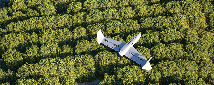
“The intention of Quantix in its development was as a low-cost tool for farmers,” Dufau said, also noting that ease of use was put front and center. “As a hybrid, it’s a drone that has a VTOL capability; it takes off and lands like a quadcopter and transitions into a fixed-wing. It carries a multispectral sensor that can assess plant health. Customers are looking at vegetative management, corridor management, encroachment, things like that.”
Quantix can cover 400 acres at 360 feet during a 45-minute flight time, though 350 acres is a more comfortable estimate should it face winds of up to 20 miles per hour or inclement weather. Data is captured by built-in dual 18 megapixel cameras that, incorporating a self-calibrating solar sensor, generate high-resolution color and multispectral data. Processed on board, true color and NDVI images appear on an included operating tablet as soon as the drone lands. Quantix integrates with AV DSS to perform advanced image processing and data analytics, with resulting one-centimeter accuracy for true color images and two centimeters for NDVI at lowest altitudes.
“It’s an end-to-end solution,” Dufau added.” With the drone, you get a license to DSS. You get your log-in and what comes with that is a cloud-based uploader, which allows you to send images to AD DSS, where they are processed, analyzed and exported to the cloud for customer viewing.”
SCALING THE OPTIONS
Three pricing packages align with users’ operational scale.
The Enterprise Bundle serves large-scale farms and enterprise ag businesses. At $8,000, it has no AV DSS monthly subscription fee and a $0.50-per-acre image processing cost, and comes with a master account and two additional user logins. Unlimited clients can be added, and client management tools are included.
The Professional Package is targeted to ag service providers, agronomists and crop consultants, and lowers the base price to $5,500. “The Pro is the [lower-cost] entry but carries a $150-a-month subscription to AV DSS and $0.30-per-acre fees,” Dufau noted. “The monthly cost becomes irrelevant and they get a much better per-acre cost. We provide client organization with DSS, and they can give their clients their own accounts, where they only see their account and their fields. Meanwhile, the purchaser can have any number of clients.”
The system continues to be honed. Added in February 2019, cross-version options allow users to view, download or import a Variable Rate Layer to create geo-referenced application maps and prescriptions. Quick-resolution imagery can lower total upload and processing time by 50 percent. Data for current and future flights can now be transferred from AV DSS into a John Deere Operations Center.
This past summer, extensive field operations showed the system’s expanding utility. “We flew over 200,000 acres with a large number of growers,” Dufau recalled. “We basically provided data for them to understand its value and the scalability of our system for large agriculture.”
MAPPING ON THE SPOT
October saw the system’s most recent evolution, the Mapper. “It allows you to process your own data,” Dufau explained. “We found that a lot of our potential customers already had stitching capabilities and the ability to process and use their own analytics and data. We were unable to tap into that market with our end-to-end ecosystems.” At $6,500, the Mapper disconnects the DSS system but still allows operators to immediately access data for field assessment. “It opens up that end of the market for people to buy a stitching license and run copious amounts of data without those acreage charges. For very-large-scale operations or people who have their own systems, the Mapper becomes a very viable tool.”
October also saw the introduction of Quick-Look™ HD, which provides an array of activity at various resolutions. It allows clients to get a tiled [partially stitched], lower-resolution image in the field, then click a spot on the tablet to pull up georeferenced high-resolution images, and then pinch and zoom navigation to explore in detail.
Dufau summarized the competitive advantages he sees across the various Quantix versions. “To go out there and fly over a thousand acres a day during solar noon, and to be able to scale to the size of your operation. It’s easy to use. It’s low cost. It has six moving parts: four motors and two servos. The operating system is designed so that anyone in your organization can fly it. It’s very intelligent. It’s very difficult to have a problem.”