 If regular drones face problems with the winds near buildings and bridges, imagine the challenges they face with the unpredictable weather and corrosive plumes accompanying many volcanoes. Still, researchers are increasingly flying drones over volcanoes to shed light on when they might erupt and the risks lava flows might have for nearby communities. One company is even developing a drone intended to withstand regular flights into volcanic plumes, a design that could also help it analyze industrial pollution and wildfire smoke.
Investigating Old Lava Flows
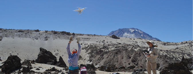
Volcanologists at Columbia University’s Lamont-Doherty Earth Observatory are using drones to explore what differences might exist in the way that lava flows advance over a variety of surfaces. “Knowing the topography onto which the flow is about to move is critical in order to make good predictions about where and how quickly the lava will go,” said Einat Lev, an assistant research professor at the observatory.
Lev and her colleagues have flown their drone over volcanic sites all over the world. Their expeditions have included scientists from NASA, because lava flows on Earth can closely resemble those on other planets, especially Mars.
“The drone gives us access to areas we just couldn’t access previously, because most volcanic terrains are very difficult or dangerous to walk on,” Lev said. “It also lets us cover a much wider area than could be achieved on foot.”
A lava flow they recently investigated at Holuhraun in the Icelandic Highlands was one of the largest ever recorded. A volcanic eruption there that began in 2014 generated a lava field more than 33 square miles large, covering a wide variety of terrain, including previous lava flows, solid bedrock, subglacial sand, a pebble-covered riverbank and a large river.
The researchers plan their missions while still in the office to ensure they have all the relevant maps available offline in the field. “We pre-program a flight plan, usually a grid, that the drone then flies automatically,” Lev said. “Because most of our targets are in remote locations, we normally download the maps and flight plans to the field tablet or smartphone ahead of time.”
The aerial photos the drone takes help the scientists classify the surfaces the lava was flowing over. They are also used to construct three-dimensional digital topography maps of the lava flows and estimate their shape and volumes.
“The reason for studying the topography of old lava flows is that it can teach us how the flow moved before it froze, and therefore how quickly the magma was erupting,” Lev said. “Previously, people had to walk and measure each block along a transect, a task that would take hours and would only sample a tiny fraction of the terrain. The drone data complements and enhances satellite-derived topography maps and images that give a wider perspective on flow field, while the drone provides the finer details.”
“For my current application, precision of around 10 centimeters in the horizontal, and about 5 centimeters in the vertical is sufficient,” Lev said. “We achieve this when we are being careful to use reliable ground control points.”
Lev and her colleagues augment their drone findings with data from ground instruments and their personal observations. For example, high-accuracy mobile GPS antennas walked along the margins of lava flows map them to a scale of less than 10 centimeters; LiDAR scanners help capture the topography of volcanic vents with millimeter resolution; thermal cameras record temperatures at cracks and hot springs; and the scientists themselves recorded characteristics of the lava flows such as their roughness and texture.
The weather around volcanoes can prove extreme. For example, in Iceland, the scientists may deal with chilly temperatures even in August, and on occasion daily forecasts may call for rain, sun, gusty winds and fog all for the same day.
 “Winds can cause the drone to lose lift and crash,” Lev said. “Fog means the pilot and observer can’t see the drone anymore, not to mention that the data would be useless. The chilly temperatures make the batteries much less efficient, making flights shorter than desired—in Chile, for example, we were camping, and nights were really cold, so we kept the batteries in an insulated bag with a bunch of hand warmers. The batteries were much cozier than us! Rain is not good for the electronics, for obvious reasons, and we try to avoid it.”
“Mostly, my strategy is that safety comes first, and that the pilot should wait for better conditions,” Lev said. “Nothing is worth losing your equipment, or an injury suffered when trying to recover it from a crash.”
Despite these challenges, drones have proven a great resource for these scientists. “Drones are giving us an entirely new perspective on the level of detail of information that is recorded in the terrain,” Lev said. “We don’t need to keep using qualitative and subjective terminology like ‘blocky,’ slabby,’ and so on—now there can be numbers put to these [terms], and the field can move to a much more quantitative realm.”
Analyzing Volcanic Gases
Instead of investigating lava flows, Jonathan Castro, a professor of volcanology at the University of Mainz in Germany, and his colleagues are using drones to examine gases emitted from volcanoes. The hope is that such research could reveal that the composition of the gases might serve as a predictive tool that “may indicate that an eruption will happen,” Castro said.
Castro and his colleagues have flown drones over Europe’s most active volcano, Mount Etna in Sicily, as well as the recently active volcanoes of Chaitén and Cordón Caulle in Chile. “Drones will pave the way to make volcanology much safer because they allow us to collect samples and see things with video and thermal infrared cameras in very out-of-the-way places,” Castro said.
The researchers use drones to analyze gases above craters and other points of emission. The aim is to examine gases before they get diluted by the atmosphere. “The data is very pristine and complements what we measure in rocks with other analytical techniques like electron microprobes,” Castro said.
Current gas sensors can measure chemicals in the parts-per-million range. “Carbon dioxide can be measured to tens of parts per million, while sulfur dioxide and hydrogen sulfide can be measured down to a few parts per million,” Castro said.
Castro and his colleagues have worked with a range of drones, such as the DJI Inspire 1 Pro, the DJI Matrice 600, and the DJI S1000+. “These drones are incredibly agile and fast, even at high altitudes, as many volcanoes are,” Castro said.
Because they need to collect data from craters and vents, stable flight is more important to researchers than speed. “When the wind gets up, however, is when it pays off to have a fast drone that can hold a position lock despite high cross winds,” Castro said.
Although drones help the researchers operate at a distance from craters and vents, battery limitations mean they still have to hike relatively close to active volcanoes. “Flying in and around volcanoes is hazardous for the pilot too because of potential unforeseen eruptive processes, unstable ground, and toxic gas in the ambient environment,” Castro said.
Currently, the drones the scientists use can fly up to 24 minutes. Castro hopes future work can employ drones with greater flight times, which would translate “to greater flight distances and perhaps less danger for the scientist,” he said.
 Major hazards the drones face with flying around active volcanoes are updrafts and downdrafts. “Downdrafts are much more dangerous because they push the drone into the crater, which in turn can result in the loss of connection,” Castro said. “This happened a few times on Etna.”
Castro explained that a volcanic crater “is like a funnel operating in reverse. Gas streams upward at several tens of meters per second, to heights of one to two kilometers or more. As a consequence, air must replace that mass of gas moving up; the air comes from the edges of the crater, creating a sucking force that goes into the bottom of the crater.”
“Eddies also may form at the edges and within gas plumes, creating very powerful downdrafts that result in the drone losing lift,” Castro added. “We’ve observed our drones dropping due to this phenomenon.”
Drones that are not so powerful can get lost due to the suction from downdrafts. “But strong drones—for example, the DJI Matrice 600—will power out of this,” Castro said.
Another challenge Castro and his colleagues have faced is highly corrosive gases that can belch from volcanoes, such as sulfuric acid. “This has resulted in the malfunction of the drone’s main control board, which in turn couldn’t be fixed,” Castro said. “Luckily, DJI supported us by replacing our drone with a new one as an effort to continue our collaboration.”
All in all, the high winds, volcanic explosions, corrosive gases and ash their drones may face can compromise the longevity of the unmanned vehicles. This leads Castro and his colleagues to “make sure that we don’t overfly our batteries—that is, return to home with about 20 percent remaining, since voltage can be rapidly drawn down when high winds come and max throttle is needed to ensure stable flight.”
Still, Castro found himself quite surprised “by how well DJI drones operate in the harsh conditions of a volcanic crater,” Castro said. “Mount Etna is 3,200 meters tall, meaning the air is very thin there and that means less lift.” The drones they use “fly as if they are at sea level, albeit with shorter flight times.”
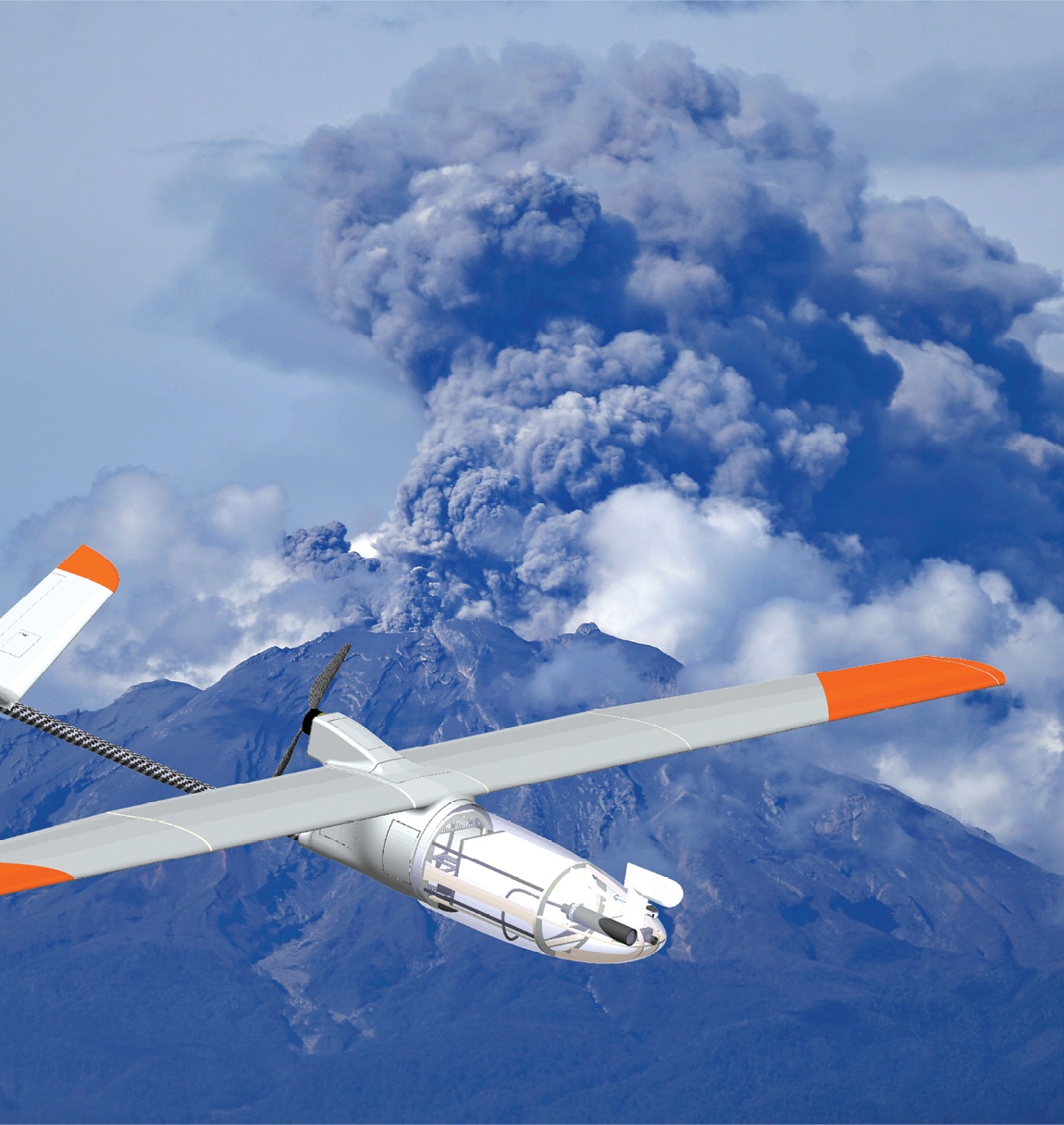
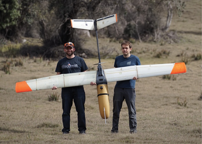
A UAS Designed for Volcanoes
To overcome the many challenges volcanoes can present, Black Swift Technologies in Boulder, Colorado, is now developing an unmanned aerial system (UAS) designed to analyze their emissions. “The system is designed to fly through a volcanic plume and give back near-real-time data,” Co-Founder, President and CEO Jack Elston said.
Elston got his doctorate in aerospace engineering from the University of Colorado at Boulder, where he and his colleagues helped develop the first UAS to officially intercept a supercell thunderstorm, the kind of storm that produces tornadoes. They later applied for and won a Small Business Innovative Research grant from NASA to develop a unique UAS-based soil moisture sensor that got them started as a full-time company. This work led NASA to suggest that Black Swift build an aircraft designed to sample volcanic plumes.
The Black Swift S2 UAS is a single-rotor fixed-wing craft with a 10-foot wingspan and a five pound payload for a total weight of 16 lbs. The drone is designed to be launched by catapult and land on its belly. “The top speed measured so far is 35 meters per second,” Elston said.
The S2’s wings cannot be too big, because volcanoes are typically in remote areas, making it difficult to lug a large aircraft over large distances over rugged terrain. Still, its wings are large enough to help support higher-altitude flights.
“We’re hoping, depending on the altitude, to fly for one hour at 10,000 feet and two to two-and-a-half hours at lower altitudes,” Elston said. “Our goal is for the final design to be able to fly at 20,000 feet.” (This assumes flight using lithium-polymer batteries; gas engines can fly three to four times longer, Elston said.)
The S2 will be equipped with downward-facing regular and thermal cameras to capture images, and a front-facing video camera to help the pilots guide the UAS in real time if needed. The drone will also be equipped with sensors for gases such as sulfur dioxide, methane, hydrogen sulfide and carbon dioxide, a nephelometer to scan volcanic particle size and distribution in the plumes, and atmospheric probes to analyze pressure, temperature, humidity, and three-dimensional wind patterns. “Getting a lot of different sensors down to a size where you can put them on a small UAS is not a trivial task,” Elston said.
The UAS can, in principle, go places that are too dangerous for manned aircraft or someone on the ground and get data on how a plume varies at different altitudes—as opposed to satellite observations, which might just capture an average value over its entire column, Elston said. “The idea is to deploy the system as close as one is able to get to the volcano and sample its plumes horizontally and vertically, say by flying to a certain altitude and then spiraling down,” he said.
The researchers designed the control systems for the S2 from the ground up, including hardware, firmware, control algorithms and user interface, Elston said. Mission monitoring is all accomplished via a handheld Android tablet computer.
“We’re adding in a fair amount of autonomy—with the user interface, you can just indicate an area where you’d like to perform sampling, and it will automatically generate a flight plan to do that, with fully autonomous take off and landing,” he said. “The human is in the loop just for the safety of the mission or to redirect the system based on data the researchers see. We’d like to continue to improve the autonomy by adding better reactive ability, such as sensing the terrain and obstacles and avoiding them.”
In addition, Black Swift is in the middle of a NASA-funded effort to use machine-learning algorithms and additional sensors to help make the UAS smarter and safer. “For instance, icing is not always easy to detect, but by looking at the performance of a vehicle and comparing it to its nominal behavior, it can deduce icing based on how the system’s degrading in how well it climbs and how much lift is getting generated,” Elston said. “It can also see if noxious gases may be affecting the UAS by the performance of the motor.”
Volcanic plumes are challenging to UAS not just because of corrosive gases such as sulfur dioxide, but also because ash particles are often laden with iron and can tamper with the electronic and magnetic components of the drone’s motor.
For the ash, “we’re designing special coverings and cowlings to ensure that the ash can’t get inside the aircraft to cause shorts in the electronics or wear on devices like servos and the motor,” Elston said. “This is tricky for certain subsystems, like the motor, as we still need to provide cooling and airflow.”
“Sulfur dioxide presents a much more difficult problem, as it permeates everything,” Elston said. “We’re going to use conformal coating and sealed containers for the electronics where possible and avoid exposed steel components. Even so, some of the components that we aren’t able to adequately protect will experience significant degradation over only a few flights through plumes depending on the concentration. For that reason we’re making most of the exposed components easily replaceable.”
Black Swift flew the S2 through volcanic plumes in Costa Rica this January to see what impacts they had on the vehicles. “Engineering a vehicle to survive high levels of sulfur dioxide or ash is certainly a challenge, but we want to make sure it can make these kinds of flights routinely in a three-year campaign that can track the evolution of a volcano over time, and not just be a one-off research aircraft,” Elston said.
Black Swift also plans to test its drone near Great Sand Dunes National Park in Colorado this summer, “where the mountains can get incredibly rugged,” Elston said. “The shear winds that you get off volcano and mountain ridges can create dangerously unpredictable turbulence. One way to handle that is to fly a small scout aircraft that can gather information on atmospheric conditions before you run the mission.”
The drone’s main scientific deployment is scheduled for 2019. Data from the S2 could lead to better three-dimensional models of volcanic plumes. This could in turn help airlines, traffic controllers and aviation authorities accurately establish flight advisories after volcanic eruptions. For instance, when the Icelandic volcano Eyjafjallajökull erupted in 2010, the resulting ash plume caused more than 95,000 flight cancellations, leading to an estimated $1.7 billion in losses.
“Better models of ash dispersal from volcanoes can help predict what kind of area a plume might cover, so that aviation authorities can tell planes to specifically stay out of certain areas instead of, say, shutting down the entire European airspace,” Elston said.
Aside from helping researchers and authorities model and monitor volcanoes, Elston noted this work could also have a variety of other applications. For example, this drone could also help investigate smog, wildfire smoke, chemical fires and smokestack exhaust. “We’re very focused on all the scientific applications drones might have, and on simplifying their operation to encourage more routine use,” Elston said.