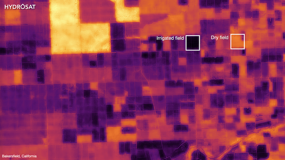
A Hydrosat thermal image differentiates dry and irrigated fields.
Like humans, plants “sweat,” through a process called transpiration. When under-watered or growing in a drought area, plants can’t release water vapor. Their temperature increases, and, eventually, their color changes—that’s when the plants begin to die.
At Hydrosat, a Washington, D.C.-based startup founded in 2017, engineers are taking advantage of thermal imagery to measure increases in plant temperature even before the actual color of the plant begins to shift. They’re doing this early detection via a low earth orbit (LEO) satellite 520 kilometers (323 miles) in space. As Pieter Fossel, CEO of Hydrosat, says, the technology is much like that of infrared thermometers; the cameras are just more sophisticated and capable of imaging the entire planet. “Our ambition,” he explained, “is that the agriculture community and growers, particularly irrigation companies, will be able to use our data for precision irrigation, so that farms have the optimal amount of water applied, at the optimal time, to promote the healthiest plant growth.”
Working with the European Space Agency, Hydrosat has used imaging data “for crop yield forecasting and irrigation applications,” according to Fossel. The company has done pilot studies with farms in Europe and southern Africa, will release a commercial product to customers this April and launch its own satellite in the first quarter of 2023.
Datasets and Applications
Hydrosat is a “data-first company,” Fossel added. Today, it provides an analytics product to customers starting with government agencies such as the U.S. Air Force and the ESA, using data from government-programmed satellites. According to Fossel, this data is not enough: It’s either low in resolution or infrequent, being available only about every 16 days, at a moderate resolution. Hydrosat’s 2023 satellite launch will provide daily, high-resolution thermal imagery.
For a complementary dataset, Hydrosat will also collect multispectral infrared data, which will allow the company to measure more than just heat emissions and predict droughts. When used for agriculture, it shows the types of crops grown and the boundaries between farms, and measures the NDVI (the normalized difference vegetation index, which quantifies vegetation greenness to understand its density). Hydrosat’s first satellite will be able to image the entire Earth approximately every two weeks, but the company wants to eventually provide temperature data for the whole planet multiple times per day by launching a constellation of satellites.
For Hydrosat, the “core focus as a company is around drought, food security and wildfire risk,” Fossel said. The forestry application works similarly to its agricultural counterpart: thermal imagery shows increased temperature in dry areas, which are risk factors for hotter and faster fires. But while the startup’s main work is agricultural and environmental, Fossel enumerated potential applications for its thermal imaging, which could be taken any time of day: ocean surface temperature for storm modeling; heat island effect in urban centers for planning and community development; and identification of illegal fishing boats at night for coast guards and national fishery organizations.
At the core of Hydrosat’s mission is addressing the impacts of climate change using satellite data. “Water issues were always in my mind,” Fossel said. “Finding this opportunity to use aerospace and satellites to help address some of these water-related issues that, we believe, are going to only increase with climate change every year—that was really an important mission for us.”