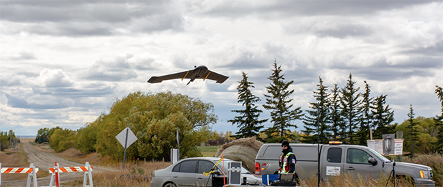
IN-FLIGHT Data and senseFly recently collaborated to fly an unmanned aircraft system (UAS) beyond visual line of sight (BVLOS) in Calgary.
This is the first time such a flight was completed in a major city, according to a news release. The drone collected mapping data to support development of a new graveyard site. The IN-FLIGHT Data team used an eBee Plus fixed-wing UAS from senseFly to conduct the fights, which aimed to demonstrate the safety and effectiveness of BVLOS flights, as well as their cost and efficiency benefits.
“As the first new municipal graveyard built in Calgary in over 75 years, this is a landmark development for the city,” IN-FLIGHT Data owner Chris Healy said. “The trial we completed earlier this year, which was Canada’s largest BVLOS UAS operations trial to date, demonstrated that this technique can provide highly geo-accurate aerial data in a variety of different applications. This project was no exception and, importantly, flying beyond line of site ensured that all of our take-off and landing areas were respectfully located outside of the graveyard.”
Because the team had restricted ground access to the site, the drone was launched and operated remotely. The site is located near a protected nature reserve and bird sanctuary, making it important to minimize the project’s environmental impact. The UAS did that, eliminating the need to drive vehicles on the site.
The data collected was delivered to the City of Calgary and will be used to support construction management as graveyard development begins. City officials will use the information to identify the real estate available at the site, and citizens have access to the data so they can follow construction progress.
“The success of this project indicates that the potential for BVLOS operations in urban, city environments is huge,” Healy said, according to the news release. “When correctly planned and executed, including ongoing communication with local air traffic control, and live air traffic monitoring within the drone’s flight software, BVLOS operations are an incredibly efficient, safe and cost-effective tool for mapping cities. With fewer personnel and operational requirements, BVLOS drone flights are key in facilitating and reducing the costs of urban UAS operations, and we’re excited to see what the future holds for BVLOS in other urban applications.”