SenseFly recently reached a commercial agreement with leading agricultural data gathering, processing, and analytics provider, MicaSense, that enables senseFly and its distribution partners to offer MicaSense’s Atlas cloud processing platform alongside eBee drones.
By making MicaSense Atlas available with senseFly’s eBee drone platforms — all of which are compatible with the Parrot’s multispectral Sequoia camera — the two companies are signaling their ongoing commitment to providing customers with industry-adapted, end-to-end solutions that make collecting and analyzing high-resolution aerial data an easy, efficient process.
“By combining Atlas with Sequoia-based drones such as the eBee SQ we can offer farmers, agronomists and crop consultants a new, easy-to-use and highly powerful crop monitoring system,” said Jean-Christophe Zufferey, senseFly’s CEO. “With both companies part of the Parrot Group, this new end-to-end offering also confirms Parrot’s position as a trusted provider of professional agricultural solutions.”
“Our partnership with senseFly will help empower growers, agronomists, and agricultural service providers to easily capture data on a large scale, for greater insights into crop health. The integration of Sequoia-based eBee drones, combined with data analysis and processing by MicaSense Atlas, provides end-users the tools they need to effectively manage their farms,” said Gabriel Torres, co-founder and CEO of MicaSense.
Under the agreement, senseFly and its global network of distributors can distribute six-month subscriptions of the MicaSense Atlas Pro plan, alongside any senseFly drone solution featuring the Parrot Sequoia, or separately on-demand. The Atlas Pro plan enables users to upload and analyze up to 1,000 acres (405 hectares) of multispectral imagery per month (custom plans for larger scale enterprise use are also available).
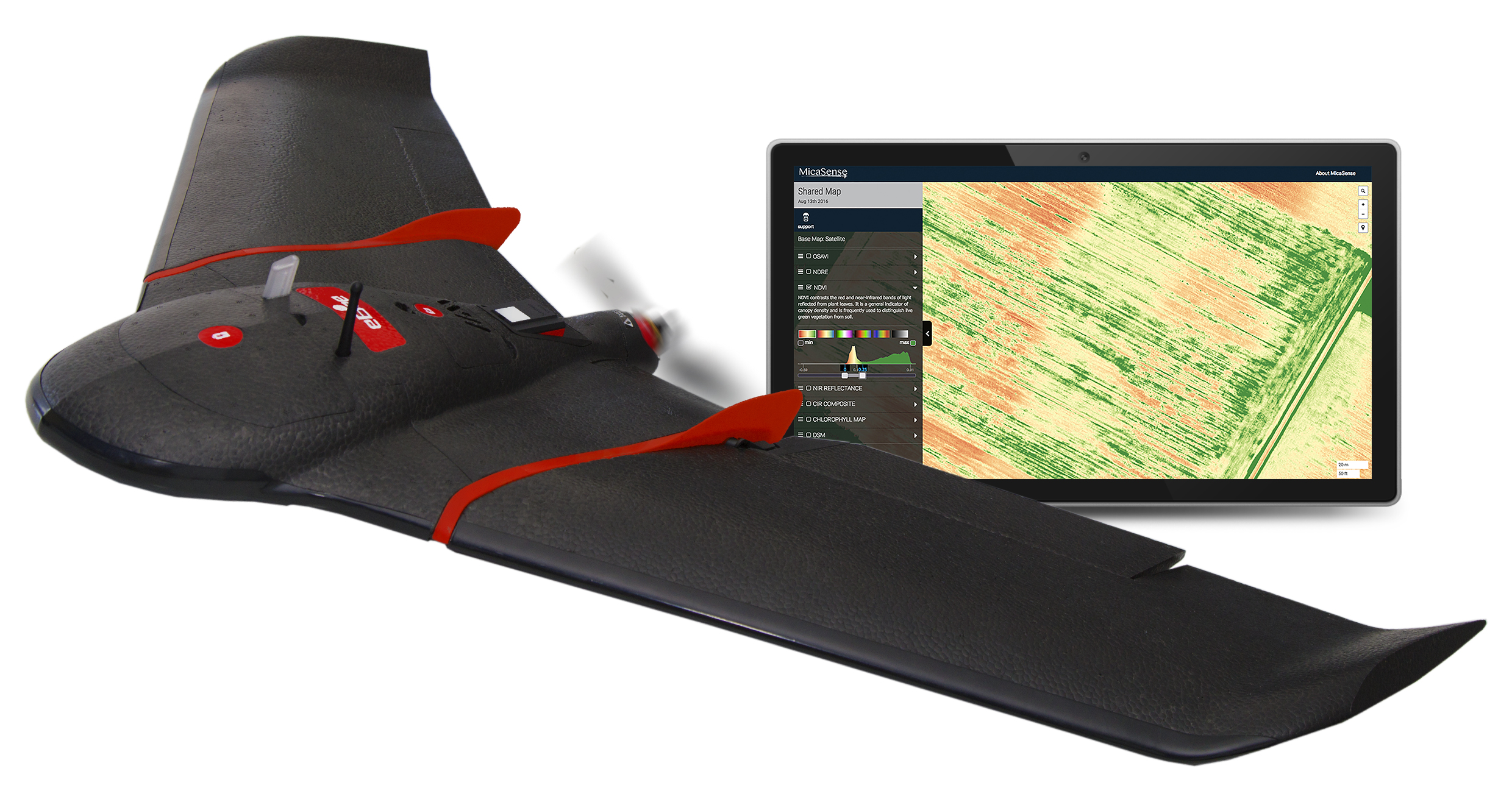
The senseFly eBee SQ is described as an efficient aerial analysis solution for the agricultural industry. When flown at 120 meters (400 feet) above the ground, it can cover 200 hectares (500 acres) per flight; several times more than smaller quadcopter drones, according to the company. It is built around Parrot’s Sequoia multispectral camera, which captures data across four highly distinct spectral bands (near-infrared, red-edge, red and green), plus RGB imagery, in a single flight.
MicaSense Atlas, a cloud-based data processing and analytics platform, generates specialized crop health outputs such as NDVI, NDRE, RGB and chlorophyll maps, providing quantitative information at the click of a mouse that can be used to properly interpret and understand the condition of a crop.
“Atlas can compute an impressive range of vegetation indices, such as NDVI, NDRE and
chlorophyll. Plus, with its timeline feature, our customers will be able to accurately monitor the evolution of their crops, or those of their clients, throughout the growing season,” added Zufferey.
Customers will receive full professional hardware support via senseFly’s existing network of distribution partners. Atlas will be supported directly by MicaSense.
More senseFly News
AirMap, a leading global airspace management platform for drones, and senseFly, announced last month that they have partnered to deliver AirMap’s airspace services to senseFly’s eBee fixed wing drones and albris quadcopter.
AirMap’s airspace platform services will be directly integrated into senseFly’s eMotion flight and data management software, providing professional operators and their drones with critical information and tools to enable safe missions.
AirMap’s industry-leading situational awareness data include airspace rules and advisories, locations of critical infrastructure, and real-time alerts about nearby manned air traffic flying in the surrounding airspace. senseFly drones will also begin leveraging AirMap’s flight planning tools and solutions for Unmanned Traffic Management, including technology that will allow senseFly drones to submit digital flight notices to more than 125 airports.
“senseFly is pushing the boundaries of drone innovation, demonstrating the tremendous potential of intelligent drones to help us do business and benefit our everyday lives,” said AirMap CEO Ben Marcus, who also serves as the industry co-chair for the FAA/industry Unmanned Aircraft Safety Team. “We’re excited to partner with senseFly to realize safe, efficient commercial drone operations.”
“senseFly solutions are designed from the ground up to maximize the operator’s efficiency and minimize risk, which is why our drones weigh only an average of two pounds and include a plethora of fail safes,” said Zufferey. “By partnering with AirMap and adding industry-leading airspace intelligence to the mix, we are taking another big leap forwards and ensuring that our customers’ commercial drone operations are safer and more effective than ever.”
senseFly’s professional aerial imaging drones have flown nearly 400,000 successful flights to date, mapping over 49 million acres across seven continents. While a human operator can take control at any time, senseFly drones are typically flown automatically, capturing photos and landing themselves. Following the creation of a terrain-adjusted flight plan in eMotion, the company’s latest eBee Plus drone can fly for 59 minutes and map up to 15 square miles on one battery charge.
The AirMap platform reportedly powers many of the world’s drones, providing the industry’s most comprehensive, reliable, and real-time airspace information and services. Millions of drones and hundreds of drone manufacturers and developers rely on the platform to access and share the data they need to fly safely in low-altitude airspace. More than 125 airports use AirMap’s airspace management dashboard to open surrounding airspace to drones, view past and current drone flights, accept digital flight notices, and communicate with drone operators.