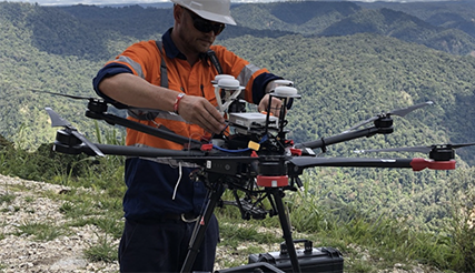
Photo courtesy of Insitu.
After receiving approval to fly unmanned aircraft systems (UAS) in Papua New Guinea (PNG) late last year, Insitu Commercial Solutions – Australia recently completed a series of aerial data operations in the country—a first for Papua New Guinea.
Insitu is the primary contracted UAS operator in PNG, according to a news release. The company has worked closely with the Civil Aviation Safety Authority (CASA), PNG and other government regulatory bodies to demonstrate safe, effective integration of drones into the country’s airspace.
The company completed a variety of remote sensing activities with visual line of sight UAS to support earthquake remediation activities for clients who live in the highlands regions. They used LiDAR and photogrammetric sensors to collect high-res data sets that were then used to create point cloud and imagery products.
Over several weeks, Insitu undertook multiple remote sensing activities with visual line of sight (VLOS) UAS in direct support of earthquake remediation activities for clients in the remote highlands regions.
“This achievement is a testament to the experience of our professional aviation staff in operating safely and effectively in some of the world’s more remote, rugged locations,” said Esina Alic, Insitu president and CEO. “This endorsement from CASA and PNG will not only mean Insitu is able to expand commercial service-based offerings throughout the Asia Pacific region, but it also will mean that PNG-based enterprise clients now can benefit from the remote sensing technologies that Insitu is providing to mining, oil and gas, environmental and government entities globally.”


