A fixed-wing UAV capable of extreme long-distance flights supplies essential research data to climate scientists and weather forecasters. The modular, accessible payload bay facilitates nearly unlimited sensor switch-outs to probe every aspect of the atmosphere.
After an inspiring meeting in 2014 with UAV designer Michel Gavart, Mistral Group CEO and BOREAL sister company M3 Systems President Marc Pollina bought the BOREAL drone outright. “I fell in love with it and also saw the possible synergies between our services and BOREAL. M3 Systems produces test measurement instruments, in particular for the automotive sector, and these tools can be used by the BOREAL drone.”
A frequent activity of the drone since then, because of its impressive long range, has been maritime surveillance of various kinds, featuring extended airborne journeys, up to 800 kilometers over open ocean, and in challenging flight conditions. The BOREAL drone can withstand winds of 60 to 90 km/hour.
BOREAL is a fixed-wing system that operates over a long range, up to 800 kilometers beyond visual line of sight (BVLOS). It has a wingspan of 4.2 m, 1.7 m length and a maximum take-off weight of 25 kg—affording up to 8 kilos of payload. It carries a new Communication and Navigation Surveillance (CNS) suite, combining GNSS, satellite communications and special security measures.
One of the drone’s most unique features is that it can adapt to any payload and is freely configurable to any suite or combination of sensors. “One of the specificities of our drone is its modularity, which allows it to integrate several types of payloads. The drone has a load capacity of 8 kilos,” Pollina explained.
Adding to its appeal for scientists and researchers is its great endurance of up to 8 hours flight time, and its access to areas at very low altitude and critical, endangered, restricted and/or remote areas not reachable by other means.
Among the many attractive possibilities that BOREAL offers scientists are:
• Its dramatically lower cost for data collection compared to airplanes or other collection means.
• It affords access to extremely large andremote areas, at closer range than can be achieved by satellites.
• Its unique suitability for mesoscale measurements. Mesoscale meteorology studies weather systems at the storm-scale level, from 5 kilometers to several hundred kilometers wide.
• Its modular and flexible design allows ample experimentation with and calibration of new sensors before undertaking mission flights in theater.
• The modular system and easily accessible payload bay also allows for many widely varying multi-missions to be conducted in rapid succession.
• It offers the possibility of “embedded intelligence,” that is, real-time processing and decision support in missions under changing and challenging conditions, such as environmental monitoring.
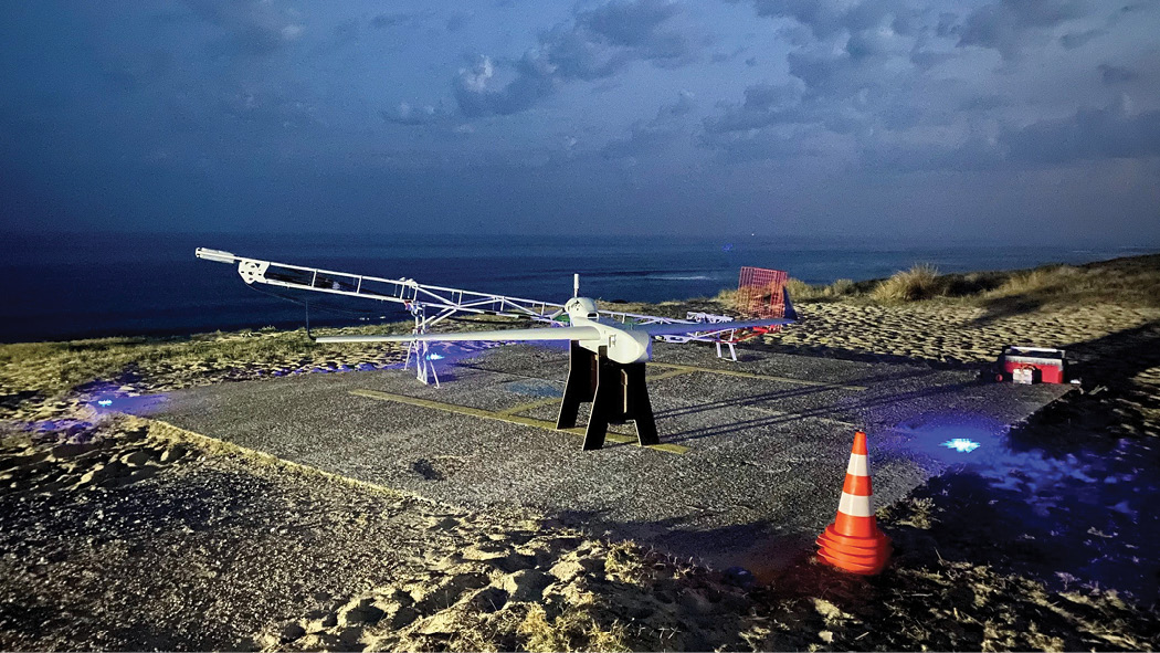
The BOREAL UAV is launched from a catapult and lands on its belly, affording relatively short take-off and landing operations in the field. A production workshop in France can output 15 drones per year under current staffing. The drone is sold with a kit for training crews, support for implementation and after-sales service.
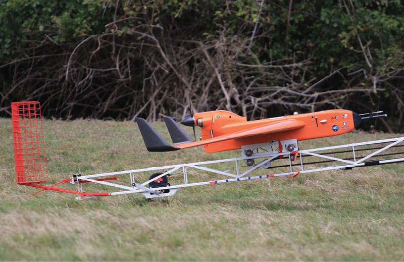
The orange BOREAL denotes scientific activity; gray, above, is for surveillance.
Storm Chaser
In February 2019, a BOREAL drone conducted a long-distance measurement over the Indian Ocean during 5 weeks, sampling the atmosphere in known hurricane zones. The aim of this campaign was to improve storm forecasting.
Taking off from Reunion Island as part of the RENOVRISK project, the drone flew 12 missions overall. In three of these the UAV reached distances from the ground control station of more than 200 km. During the longest flight it traveled a total of 610 km in 6 hours 18 minutes.
The RENOVRISK project studies tropical cyclone genesis, to gain an understanding and detect the meteorological conditions that could lead to the formation of a cyclone. It aims to improve modeling tools and knowledge of tropical cyclones on the islands of the Southwest Indian Ocean (SWIO). Its ultimate aim is to make populations and territories in this region less vulnerable to cyclones and climate change.
The BOREAL UAV was the only aircraft in this project. The drone flew into the lower layers of the atmosphere (0-1000km) to understand cyclone formation. The BOREAL drone closely approached active cyclones, for example the March 2019 Tropical Cyclone Joaninha, in international waters between Diego Garcia and Reunion Island in the Southern Indian Ocean.
Overall, BOREAL conducted 50 hours of scientific measurements, up to 250 km from the base, in 10 flights averaging 5 hours for a total of 5,000 km.
The CNRM (Centre National de Recherches Météorologiques) operated the BOREAL UAV conjointly with ATMOSPHERE’s Satellite Communication (Satcom) system, providing connectivity to the UAV BVLOS.
BOREAL is equipped with a transponder (24-bit S-mode) for integrating flights into international airspace, and a radio frequency/satellite communication system for long distance flight. The avionics system consisted of a GNSS receiver, an inertial measurement unit, a transponder, a dual communication system (radio frequency and satellite) and real-time feedback of the onboard camera to avoid overflight of any ships.
The payload of 5 kg included an esoteric array of sensors to measure air-sea exchanges: multi-hole 3D wind and turbulence probe, particle counter and number size distribution, altimetry radar (wave height), temperature of sea surface, downwelling broadband solar radiation, pressure/temperature/humidity and real-time video.
In particular, it assessed the concentration of sea salt in the atmosphere; this, scientists have discovered, plays a determining role in the convective development process leading to the formation of cyclones.
All instrument data, georeferenced by the onboard GNSS receiver, was viewable in real time from the ground station—hundreds of kilometers away.
“The BOREAL platform uses several GNSS sensors,” Pollina said. “A GNSS/IMU unit provides position and attitude to the autopilot; the GNSS-based ADS-B transponder sends surveillance data to air traffic control; and in the payload the GNSS sensor is used in several ways depending on the measuring instrument. Usually GNSS and IMU data are recorded for post-processing to reach high accuracy for LiDAR measurements, as an example. In the future it can be expected that PPP through the E6 Galileo signal will provide significant benefits in pay-load measurements.”
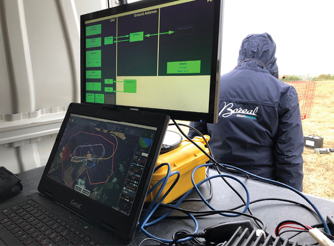
Ground control draws real-time data from onboard instruments.
Look at Clouds from Both Sides Now
In another campaign to aid scientists in understanding weather patterns and phenomena, BOREAL flew to the island of Barbados in the Caribbean as an agent of the CNRS, Météo France, the Max Planck Institute and several international institutions. The EURECA4 project (Elucidating the role of clouds-circulation coupling in climate), one of the largest recent climatological campaigns, took place in January–February 2020, compiling during a monthlong profile of the trade wind cumulus clouds characteristic of the tropics, and their accompanying mesoscale eddies. The campaign is an important event in understanding the process of global warming, reducing uncertainty about rates and extent.
A slight change in the properties of these clouds, in this region, could have consequences on the climate globally. The eddies are believed to play a role in the flow of carbon dioxide and heat between the ocean and the atmosphere. For 40 years, climatologists have sought to fully understand this key parameter on which the extent of future global warming depends. They have learned the way in which clouds react to global warming lies at the heart of the problem.
BOREAL carried a similar though not identical instrument payload to the flying lab it transported over the Southwest Indian Ocean. It joined four piloted aircraft, four research ships, buoys and underwater gliders, all gathering data from the full range of oceanic and atmospheric strata to study the interface between the two domains.
The ocean, functioning as the main regulator of global climate, is especially turbulent in this region. The mesoscale eddies, less than 100 km in diameter, stir up water that is warmer than its surroundings. The exchange of gases and energy, on both a meter scale and tens of kilometers scale, between the ocean and the atmosphere, lead to capture of CO2 and heat by the ocean. These exchanges are not fully understood nor adequately represented in climate models.
The data obtained by BOREAL and its many confreres will help update models critical for climactic understanding and the planning of countermeasures to increasing CO2 emissions.
Utility Player
BOREAL’s flexibility and extreme range have brought it into play in a number of other investigative initiatives:
TERRISCOPE: a research platform dedicated to airborne imagery for studying the environment and territories of the Occitanie region of France. BOREAL carried compact and miniaturized systems: next generation hyperspectral imagers, full-waveform topographic 3D LiDAR, multispectral infrared cameras, and an onboard LiDAR for wind field measurements in the lower atmospheric layers.
ETOILE: an oceanographic measurement campaign to characterize the internal waves near the continental slope in the Bay of Biscay from sea-surface observation.
Surveillance: BOREAL overflew small fleets off the coast of Brittany, testing visual identification of boat registration numbers in an area where illegal scallop poaching is a problem.
Overall, the long-range drone has proved its mettle in a variety of missions, and satisfied scientists with its flexibility and utility as well as its courage. From cyclones to clouds to forested mountain ranges, the unmanned aircraft has helped push out the frontiers of knowledge. It sits, a bit impatiently, awaiting the next challenge.