As drone technology and data analysis matures, so do the growing number of use cases in construction and mining.
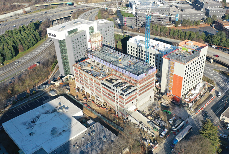
Savannah College of Art and Design—Spring Street: The project is located on the Atlanta campus of the Savannah College of Art and Design. It includes a 12-story residence hall and dining hall on the north side of the site, along with the core and shell of the campus store along Spring Street. Image: CLAYCO
A drone flies over every CLAYCO jobsite at least twice a week, collecting critical data for the Chicago-based construction firm’s clients. The videos created communicate how jobs are progressing, what additional safety measures might be needed, how material is being distributed and where equipment is located. Imagery from the same flights is leveraged to closely inspect for accuracy, for example verifying that utilities are placed in the right location and that the building structure is positioned in exactly the right place.
CLAYCO first began deploying drones about 10 years ago and was the first to receive a waiver from the FAA to do so on a construction site, CLAYCO CTO and vice president Tomislav Žigo said. Since then, the drone program has grown to about 75 UAS and 100 pilots. Žigo has seen the technology evolve over the years, with sensors becoming smaller and more sophisticated and the platforms more nimble. Data processing and accuracy also have improved significantly, with advances in AI and machine learning bringing more automation to the process.
Mine operators have taken notice as well, and much like in the construction industry, are deploying drones on a weekly and even daily basis to quickly obtain critical insights into operations. They can leverage drone collected data to make accurate volume calculations and identify issues that could compromise safety, to name a few of the growing use cases.
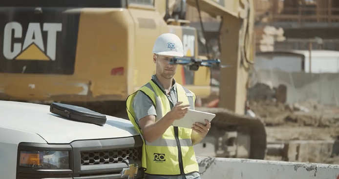
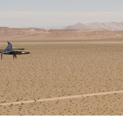
Skydio autonomy enables even minimally-trained employees to fly impactful missions. Image: Skydio
Drones are no longer only used for niche cases here and there, said Andrew Carey, senior account executive, AEC—global imagery and remote sensing at Esri. They’ve become established parts of the routine and simply are expected.
“If you don’t have a drone in your toolkit, you’re losing business,” Pix4D Customer Solutions Manager Tom Cerchiara said. “Must surveyors who do engineering and design work have at least a couple drones, if not one in every truck.”
As UAS move toward automation, they’ve become easier to use—and that’s spurring adoption across both industries. Challenges with data storage and management still remain, but software advancements are making it easier to extract the most valuable insights and then share them across organizations. There’s also a push for straightforward integration with industry-specific software as well as merging data with other inputs such as terrestrial LiDAR and data collected via mobile phone.
Today, we’re seeing “mature solutions,” that can support customers in more steps across the workflow, said Aviad Almagor, vice president of technology innovation at Trimble.
The once narrow scope has broadened, opening up even more possibilities. But more flights means more data to manage.
“Every drone program we see is growing,” Carey said. “There’s no longer a need to prove drones can collect quality data. The challenge now is sharing that information and building value by getting that data to the people who need to interact with it.”
Autonomous Road Trains: From Pit to Port
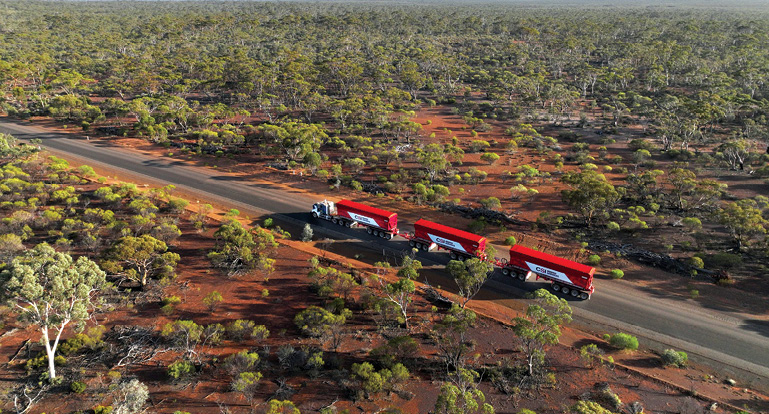
Hexagon AB will provide an autonomous haulage solution for Mineral Resource’s Onslow Iron project in Western Australia, a world first. Image: Hexagon.
Labor shortages have had a huge impact on mines,making it difficult to find skilled machinery operators and drivers. Those who do hire on often only last a month or two, particularly if the mine is remote. This puts a larger burden on those who return, making an already dangerous job that much more volatile. It also makes it more difficult to hit productivity goals.
To solve this growing problem, the industry is adding more autonomy to its operations. Most mines already rely on autonomy in the pit to increase safety and minimize errors. Now, we’re seeing automation in the haul trains traveling to the ports.
Through an agreement with Mineral Resources, Hexagon AB will provide an autonomous haulage solution for the company’s Onslow Iron Project in western Australia—a world first. The fleet of 120 fully autonomous road trains and 360 trailers will offer new levels of productivity, sustainability and cost savings for the mine.
“The need in the pit has caught up to the mine,” said Michael Ritter, who oversees Hexagon’s Autonomy & Positioning, Mining and Agriculture divisions. “For 120 trucks, the mine would need 500 drivers to cover shifts, vacations, sick days and people just not showing up.”
Because it’s so difficult to find and retain workers, mine operators live with uncertainty, Ritter said, never knowing what the labor force will be week to week. Autonomous road trains provide that certainty, overcoming logistical challenges, reducing costs associated with workers and improving safety.
The Road Ahead
Each triple trailer road train, weighing about 80 tons, can travel between 80 to 100 km an hour and will carry 330 tons of iron ore about 150 kilometers.
Hexagon will deliver 10 trucks a month through the end of the year, with the goal of eliminating safety drivers between May and August. Mineral Resources recently gave the first custom off-road triple road train to Hexagon to convert to autonomous operation, a critical milestone.
The autonomous road trains will travel along a private, traffic-controlled road, Ritter said, and will be equipped with Hexagon’s CAS 10 proximity warning and stopping collision avoidance system. Safety is paramount, with all software and equipment engineered to safety critical standards.
“Everything mission critical is at least redundant, sometimes it’s more,” he said. “And all of those parts come with scheduled replacement because you don’t want them to fail or wear out. The mining operator and us as a manufacturer work hand in hand on the lifetimes and service schedules.”
Why Hexagon
Hexagon has deep expertise in both mining and autonomy, offering solutions that provide underground autonomous positioning for drills, haul trucks and other equipment. Being the first to offer autonomous road trains is a natural evolution.
“It’s mine operations, it’s mine safety expertise, it’s automotive safety expertise and of course it’s our expertise in making vehicles autonomous,” Ritter said. “The synergy between our long history in mine operations and our long history in safety critical has come together in developing these autonomous road trains.”
The Applications
Drones are being deployed for various applications in construction and mining, including planning, design, inspection and emergency response. Higher levels of automation make data capture and processing easier and faster, with 3D models, contour lines, meshes and surface models among the deliverables. Inspectors and project managers can safely reach areas not reachable before, reducing risk and enabling better decision-making.
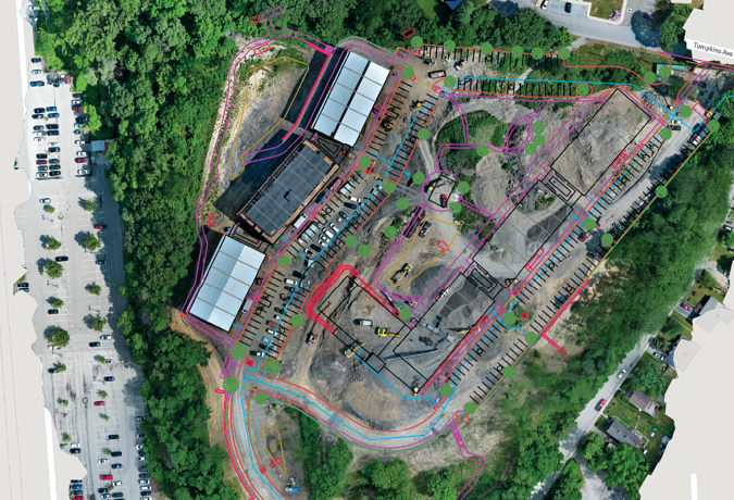
Design CAD file overlay of ongoing construction sites for monitoring and planning. Image: Pix4D.
Construction
Boston-based Windover Construction has deployed drones to collect imagery on jobsites for years, and recently added thermal and LiDAR payloads as well as ground control points to expand applications and improve accuracy to the centimeter level, Chief Innovation Officer Amr Raafat said.
“We not only use drones to take pictures, we use them to mitigate risk,” he said. “When it comes to risk on site and avoiding schedule delays, drones pay for themselves. We find surprises early, before they become an issue.”
Windover is flying sites almost weekly for various applications, including using FLIR thermal sensors to identify hot spots in building envelopes and roofs to improve sustainability. They’re also leveraging LiDAR to identify small anchor poles in foundations for quality assurance/quality control (QA-QC), overlaying a point cloud over the as-built to show the steel company any discrepancies between reality and design. They can then make adjustments to ensure the steel lines up with the bolts, avoiding the delays caused if they don’t.
The firm also deploys drones pre-construction, Raafat said, scanning sites with LiDAR. Once the data is processed in solutions like Autodesk Civil 3D, they can use a model of the foundation to perform a field analysis, calculating how much dirt they’ll need to cut and fill, the amount of digging they’ll need to do and how much concrete they’ll need to pour.
Wingtra works with several construction companies, including one in Dubai that flew two WingtraOnes in parallel to map 70 square miles in 14 days. Another deploys the system to monitor all phases of its construction projects, Senior Product Manager Javier Ortiz de Urbina said. They gather accurate models of the terrain where they must cut and fill, and later use the drone to monitor progress and keep up with road maintenance. The data can tell them if any cracks need fixed or streetlights need replaced.
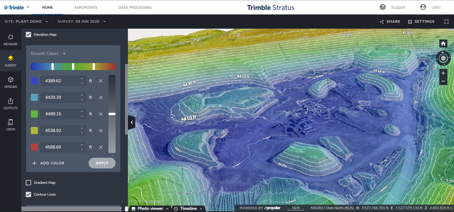
Trimble Stratus software is making it easier to integrate drone data into construction workflows by providing frequent, detailed images that offer a rich representation of the jobsite and can be used for better decision-making. Image: Trimble.
Volume calculations that ensure accurate payments are another popular use case. Cerchiara, who ran a surveying firm that specialized in drone mapping for 10 years before joining Pix4D, took on a job flying a 350-acre site in New York because the client was struggling to keep track of the volumes and material being moved with traditional methods.
“It took the surveyors a month to do all the topo work, and by the time they were done everything had changed and they had to start over,” Cerchiara said. “We flew the project once a month for a year, sometimes more frequently, and they used this data for everything from cut and fill analysis to volume calculations to the daily subcontractor and safety meetings. They’d put ortho images and 3D models on the big screen in the office every morning and gather around to discuss why is this steel here or this dirt pile there. They used it for logistics planning and safety analysis.”
Drones are being deployed more for inspection, Cerchiara said, to help ensure plans have been followed and the project is built to design and municipal standards. For example, Cerchiara once worked with an inspector who needed to confirm structural bridge beams were placed in the correct spot on a variant plate—which was 80 feet in the air. Instead of sending someone up a scissor lift to inspect, they created a 3D model from data collected via drone. The model was put into Pix4D software to check elevations and horizontal alignment.
There’s also been a shift toward fully autonomous drones, said Jason Tillman, director of product marketing at Skydio. Such systems can follow pre-set flight paths and make decisions in real-time—translating into more efficient site surveys, improved safety and more accurate data collection. It also reduces the number of skilled pilots needed on site.
Skydio customer Caltrans manages more than 50,000 miles of California’s highway and freeway lanes, provides intercity rail services, and permits more than 400 public-use airports and special-use hospital heliports. They deploy UAS to monitor sites and assess construction projects.
“The ability to fly and document progress over time is really key, and being able to do that in an autonomous fashion that is repeatable over and over is absolutely huge,” Caltrans Senior Transportation Engineer Aaron Chamberlin said. “We’re going to be able to compare changes over time, determine if something was installed correctly, and have that data when we need it.”
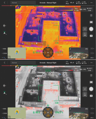
Thermal Drone Inspection at Windover’s Multifamily Project. Image: Windover
Mining
Just a few years ago, there was still resistance to adopting drones in the mining industry, said Matt MacKinnon, founder and president of Unmanned Aerial Services. Worried about false promises, many wanted to see how the technology evolved. As it has matured, adoption has expanded.
“It went from just using drones for fringe cases when they had no other way to get information to now drones are the first approach they’ll take,” MacKinnon said. “The biggest shift in the industry is probably the ingestion of data and seeking out point clouds and other digital formats.”
There are several phases in a mine’s lifecycle, including exploration, planning and design, geology analysis, operation and reclamation—and drones can be leveraged for it all, Ortiz de Urbina said. Drones gather data to create large topographical surveys during the exploration phase, for example, and can collect critical information about the state of the mine after a blast or to take volume calculations to track how much the mine is producing.
Drones are often used to monitor high walls and tailings dams, Ortiz de Urbina said. Tailings dams are very unstable, as they are filled daily with waste from the mine. They must be monitored constantly, and that’s both easier and safer to do with a drone. High wall gradients also must be monitored to protect against landslides.
Safety barriers are critical as well, Ortiz de Urbina said, as they prevent vehicles from falling off a cliff. Drones can collect images of these barriers and then put them into software from companies like Pix4D and Esri to assess their health. If a barrier is too low and needs replaced or if a road has become too steep, mine operators see that right away and make adjustments.
With drones, workers can complete such inspections from the safety of their office without having to stop mining operations.
Mine operators also deploy drones for comparative purposes, MacKinnon said, like monitoring change detection or convergence modeling. They’re working at deep depths, but the ground has a tendency to try to fill back in and must be monitored constantly. Drones enable greater frequency.
Pix4D has several customers leveraging drones to map giant mines, Cerchiara said.
“The big advantage to drone work in mining is if you look at some of the bigger fixed-wing drones like Wingtra, Sensefly or Quantum-Systems, they’re designed to cover large areas,” he said. “They’re becoming more prevalent in mines because they can cover 500 acres in a flight and that’s a huge advantage over traditional methods. And they get more accurate volumes in piles and topography than traditional surveys, and of course there’s the safety element of not putting people on the mine floor.”
Service provider Firmatek typically flies mine sites for inventory management and mine planning, including stockpile measurement and cut and fill calculations, CEO Lauren Elmore said. Many of their customers want to track how much product is removed over time and what they have in reserves. Firmatek can provide that analysis after flying a site, or clients can do their own calculations in the company’s Kespry platform. Everyone who needs access to the information to make decisions has it, whether they’re onsite or at corporate headquarters.
Drones have become common tools in mines, with MacKinnon remembering a customer who immediately wanted a new Flyability Elios 3 after it was damaged during a mission. They only had it for two months, but they were flying it almost daily and already had come to depend on it.
“We don’t find anybody using a surveyor or traditional aerial fly over company to do this type of work,” Elmore said. “It’s all drone companies, which is a sharp contrast to 10 years ago or even five years ago. The tech has gotten drastically better and a lot cheaper, and it’s providing good data.”
Merging Data
Esri’s ARCGIS Living Atlas is a selection of curated data layers, Andrew Carey said, such as live traffic feeds, census data, traffic trends and maps. Customers can search in datasets and pull-out existing AI models to apply to and compare with drone data, which also comes with location information. Users can train their own models to identify things like rebar caps or paint lines. GIS and survey departments can produce rich datasets they can compare over time.
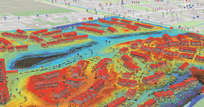
Overlaid LiDAR and imagery capture integrated into a common system for a single source of truth. Image: Esri.
Data Management Pain Points
As drone programs grow in both industries, so too does the amount of data collected and the quality and size of the images—exasperating an existing challenge to drone adoption.
Many firms that bought a drone two years ago for a specific use case may now have 20 drones and 20 pilots and are tasked with running an entire program from system maintenance to pilot training, Carey said. There are also more people interested in and asking for data from specific dates, making the collaboration piece critical.
“It is difficult to properly share the data because specific software is required to open and view it,” Ortiz de Urbina said. “There are some cloud solutions that alleviate that problem, but it’s still a bottleneck.”
Then there’s the processing piece, he said. Even if you have a drone that gathers reliable data, it still needs processed, and various factors must be considered to achieve a quality result.
It comes down to understanding how to extract usable data out of the 3D models, Cerchiara said, and that requires sophisticated software.
“Combining detailed imagery from high-resolution cameras along with precise positioning data from RTK/PPK modules is crucial in creating accurate 3D models of buildings and structures,” Tillman said. “These models play a significant role in effective planning, monitoring and structural analysis in construction, highlighting the importance of software compatibility for advanced modeling.”
The large ecosystem of solutions provides many options, but that can make it difficult to know what to use when, Ortiz de Urbina said. Even though the solutions available today are user friendly and yield similar outputs, a certain level of expertise is still required to understand the capabilities and what might work best for a particular project. That knowledge is also needed to choose the right coordinate system and to properly analyze the data, especially when there’s complex terrain involved.
The drone data must talk to different platforms. Solutions like Trimble Business Center (TBC) provide capabilities that help users process data and link it to other solutions in the ecosystem like Esri’s ArcGIS Living Atlas.
“The infrastructure to support this type of data is improving quite rapidly,” Almagor said. “The cloud-based solutions are scalable and adjust to demands quickly. But it’s really about extending what we envision as a fully automated process from reality capture to data analytics to approval of work and payments. All of this should be automated. The more we automate, the better the value of this technology. There are still some gaps, but I expect this to improve over time, with AI certainly part of it.”
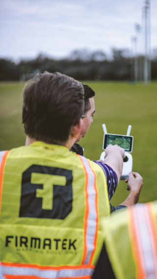
Drones are being deployed for a growing number of construction and mining use cases. Image: Firmatek.
Getting to Automation
Drone operation is becoming more automated in all phases, Ortiz de Urbina said. Less technical expertise is required, opening up more opportunity.
While analyzing the data is still “quite manual,” that’s beginning to change too, he said. There’s a lot of movement toward AI integration, and there’s software available for just about any analysis. There is software that can differentiate trees from power lines and tell the distance between vegetation and power lines, for example, so users can decide if there needs to be an intervention.
The AI piece is still in the beginning phases, Ortiz de Urbina said, but it has huge potential for applications like detecting defects, as-built comparisons, identifying road markings—the list goes on and on. These maps contain a lot of information that needs classified, and having AI embedded in the software would make the process faster and more efficient.
“In construction, everything has to do with progress reporting and assessment of safety on the jobsite. That will all be automated,” Ortiz de Urbina said. “The same in mining. All the analysis of the high walls to make sure they’re safe and the tailings dams to make sure they’re stable and the old road barriers to make sure they’re compliant with regulations, AI will be able to tell us all of that without the manual work that’s done today. Drones are saving time on the data capturing side, but there’s still a lot of work that needs to be improved in post processing. That’s where AI will play a big role.”
Some software, like Pix4D’s, offer extraction features. For example, if users want to remove a pipe from their model to create a 3D infrastructure plan, Cerchiara said, they can click on it and all points on the pipe will be automatically selected, classified and removed.
Many users only process approximately 20% of the data they collect, Almagor said, but employing AI to quickly extract relevant information will allow users to get more insights out of the data while improving efficiencies.
Tillman describes AI and computer vision as foundational to Skydio’s RTK enabled drones. It enables them to fly autonomously and to automatically capture and then process data.
“There’s significant potential in tapping further into AI for automatic defect detection, proactive identification of potential problem areas, and more,” he said, “based on real-time data collected at sites.”
CLAYCO leverages AI to monitor how equipment is being used on a jobsite, Žigo said.
“The staff is trained on how to handle the data,” he said. “Now, most of our focus is on extracting as much as we can using different techniques like computer vision or blending UAV data with BIM to understand where we need to react and how we need to react.”
While AI is a useful tool for monitoring and visualization, Cerchiara cautions it shouldn’t be used for decisions with real-world implications. Leveraging machine learning to train a machine to find a crack is one thing; using AI to determine if the crack is a safety issue is a step too far, at least with where the technology is today. Humans still need to make those critical decisions.
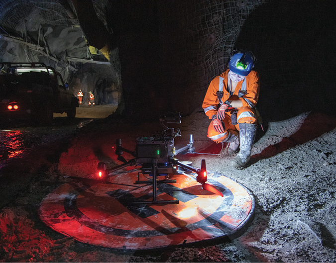
An underground surveyor gives the Emesent Hovermap system one final check before performing a fully autonomous mapping mission 8,000 feet below sea level at Glencore’s Kidd Creek Mine in Ontario, Canada. Image: Unmanned Aerial Services.
Looking Ahead
Ortiz de Urbina sums up the future of drones in construction and mining in one word: democratization. Today, experts are still needed to process the raw data, creating a bottleneck. As the technology continues to get easier to use, that barrier will disappear, speeding up adoption.
Full autonomy, of course, is the goal, and has become more important in today’s labor shortage, Žigo said.
Integration with industry software is also critical, as is merging the data with other inputs to create accurate, detailed maps. In the future, for example, images and point cloud data terrestrial scanners, robots, cameras mounted on machines and hand-helds could be integrated using tools like Trimble’s Stratus or TBC, with each providing different angles to enrich the understanding of the site.
“We’re sharing the data not just with the office but also with the actual machines performing the work,” Almagor said. “Imagine feeding data into an autonomous machine to make sure the actual work being done on the site is according to the design.”
Advances in edge computing will help make such integrations possible, Almagor said, as it will improve data flow as well as communication.
Deploying drones for equipment inspection is still largely untapped, Elmore said, but is an application that could be “powerful.” MacKinnon sees a future where drones are part of automated mines, where front end loaders are working in tandem with haul trucks. Advanced SLAM and AI applications will play a key role in getting there.
BVLOS flights will open up more applications, Cerchiara said, with advancements in collision avoidance techniques making that possible. He also sees drone data being used more in conjunction with images gathered via mobile phones. The site can be flown with a drone weekly or monthly and maps and models updated daily with cell phone data. Drone-in-a-box solutions also will become common, with drones automatically going out each day to perform inspections or monitor construction progress.
Tillman envisions dock-based operations where drones autonomously recharge, sync data and receive new commands. The hubs ensure continuous operations, boost productivity and enable global project management.
Eventually, drones will have an impact beyond just collecting data, Raafat said.
“I expect drones to start making things,” he said. “In the future, drones could be tying rebar for a large project or laying out bricks, combining robotics with drone technology.”
As drone programs mature, operators will gain a better understanding of how the data can be used to their benefit and how to interpret it, Žigo said, “eliminating the unnecessary data burden” and “pinpointing” the most meaningful data for each project.
Digital twins, smart cities and connected construction are “really good concepts for society, for industry, for safety, but collecting and modeling and analyzing that data is still time consuming and expensive,” Cerchiara said. There just aren’t enough surveyors or inspectors who care about it. That’s where drones can make a huge impact.
“Any construction company that wants to be competitive needs to harvest the benefits of visual intelligence that comes from drones, “Žigo said. “Whether the drone is a quadcopter or a fixed wing is irrelevant. What’s relevant is the amount of information collected that makes jobs safer and keeps projects on schedule.”