System integrators around the world are on the hunt for low cost, high performing, high accuracy airborne solutions to meet the rapidly growing unmanned aircraft system (UAS)-based LiDAR market. Yet, a mobile LiDAR mapping system configured for a UAS at a reasonable price point seems just out of reach. It requires a few vital components—including IMUs, GPS receivers and LiDAR sensors—that are all lightweight and small and all connected. Historically, it’s been a complicated, costly combination.
What every system integrator wants in a commercially available, mobile LiDAR solution for a UAS is a fully integrated solution that provides full attitude, heading and position in static and dynamic conditions…for several thousand dollars instead of tens of thousands of dollars.
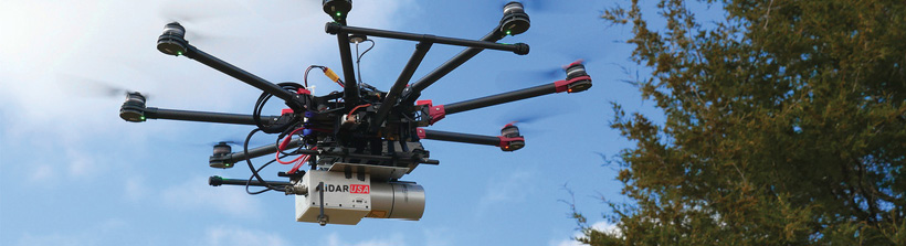
Sounds crazy right? Not so fast. Industry innovator and CEO of LiDAR USA, Jeff Fagerman, seems to believe the challenge is less about technology accessibility and more about creative integration, and he’s proven it with the recently released ScanLook Revolution mobile scanning solution.
INS Incentives
To take advantage of UAVs for the booming aerial survey and mapping market, Alabama-based LiDAR USA looked to several INS and GPS offerings to deliver its lightweight (1 to 1.6 kg) ScanLook Revolution that was introduced in fall 2016.
“A year ago, among UAVs, there were myriad choices. But the choices were difficult. We needed to build a system that was smaller as the larger systems were $25,000 to $65,000,” Fagerman said. “Weight was a huge factor as at the time it was 840 grams for a LiDAR puck alone [and] that didn’t include the cable.”
So Fagerman went on a quest. He and his team worked with several companies to try to get the size and cost down on the inertial navigation system in particular—and found a partner with VectorNav.
Jakub Maslikowski, director of sales and marketing for Dallas-based VectorNav, said LiDAR USA reached out to his company in early 2013. “They [LiDAR USA] have a good picture of the market and what everyone’s offering. At the time Jeff [Fagerman] reached out to us, we had our VN-100 and VN-200 inertial navigation solutions on the market,” he said. “The VN-200, in particular, offered key capabilities including the necessary accuracy and weight to meet some of his needs.”
The VN-200 inertial navigation system incorporates 3-axis accelerometers, 3-axis gyroscopes and a single GPS receiver—ideal for applications where there’s dynamic movement, such as a moving UAS, boat or automobile. The system takes measurements from the GPS, gyroscopes and accelerometers and, with help from the Kalman filter algorithm, derives position, velocity and attitude.
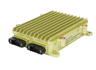
The challenge for Fagerman’s UAS-based mobile LiDAR solution is what happens in low dynamic or static conditions, such as when a UAS is hovering. That’s where VectorNav’s subsequent release of the VN-300 Dual-Antenna GPS-Aided Inertial Navigation System (INS) came into play. At a lightweight 30 grams and a size not much larger than a postage stamp, the VN-300 builds on the VN-200 architecture by incorporating two GNSS receivers. Two GPS antennas connected to the VN-300 spaced a certain distance apart and carrier phase interferometry enable the VN-300 to estimate the heading solely from GPS signal measurements when the vehicle is stationary.
The VN-300 combination was exactly right for Fagerman’s ScanLook Revolution. Besides the VN-300 INS, the low-cost LiDAR mapping product incorporates a LiDAR scanner, onboard data logging and WiFi interface for remote control and provides sub-meter precision—an accuracy that is suitable for a range of applications where relative position measurement, rather than absolute centimeter-level position measurement, is a factor. For example, powerline encroachment is an important application because a utility company doesn’t need to have a high level of accuracy to make an assessment, Fagerman added.
The company believes the law enforcement market may be a good fit for this technology in future years. “We did an accident reconstruction job and surveyed a mile leading up to it. We manually surveyed it,” Fagerman explained. “With this system, a car can drive right up to it—or a UAV can fly right up to it—and manually survey it. It literally takes one pass to do it.”
Fagerman also noted some systems survey individual points and can be quite costly. “With [ScanLook Revolution], it’s one time down the street and surveyors get all curb and gutter measurements, all the mailboxes, all the fire hydrants,” he said. “If someone calls and wants all the utility poles—they already have them.”
Another emerging UAS survey and mapping market for LiDAR USA is in Africa and South America, where the company has systems installed in Ecuador, Columbia and other countries, Fagerman said.
“Government finances are limited and these markets are often labor-intensive and dangerous. They have nothing in terms of survey right now—they don’t know where the railroads cross the roads,” he said. “They can get this [survey and mapping] down to the centimeter-level.” High Precision Possibilities
But the ScanLook Revolution is not just a submeter mobile LiDAR solution. For more high-precision performance, Fagerman has also integrated the Tersus GNSS receiver developed by Tersus, a China-based startup.
“More and more people have recognized the importance of precision positioning, and, hence, have found new applications for GNSS technology,” said Xiaohua Wen, Tersus GNSS founder and CEO. “Location awareness has become a key feature of the latest high-tech products, such as virtual reality (VR), UAVs, and autonomous ground vehicles.”
Wen, who raised $3 million to help start Tersus, said the BeiDou and Galileo constellations bring increased opportunities to improve GNSS’ performance. “The Internet of Things (IoT) is creating new demands for low-cost and low-power location trackers,” he said.
The company, which said RTK survey and mapping can still be expensive for users, recently rolled out its Precis-BX316 GNSS RTK board for precise positioning and heading. The board is suitable for UAVs and surveying, but the company believes such new markets as VR and autonomous vehicles will drive the market for RTK.
“Emerging applications such as UAS surveying and mapping, laser scanning mapping, remote sensing imaging and VR, not only require high precision at the centimeter level, but also operate in moving, kinematic modes. That presents both challenges and new opportunities for us,” Wen said.
The Tersus Precis-BX305 is a compact GNSS RTK board that offers real-time, centimeter-level positioning as well as flexible interfaces for such applications, in addition to UASs, as precision navigation, agriculture and surveying, according to Tersus. The unit can be integrated into other host devices, or can serve as an independent positioning system. The board uses a standard serial port or UHF module for communication. In addition, a PicoBlade connector allows it to be integrated with host devices or autopilots.
“We have used the Precis-BX305 as a base and rover, with the rover mounted on our [ScanLook Revolution] system,” Fagerman said. “Revolution uses the VectorNav VN-300, which has two L1 GPS receivers. By adding the Precis-BX305 onboard, and post processing its results, we can fit the VN-300 trajectory onto the Precis-BX305’s trajectory—thereby getting centimeter-level results.”