NOAA researchers are using unmanned systems in the air and on the water to study hurricane boundary layers for clues to their rapid intensification.
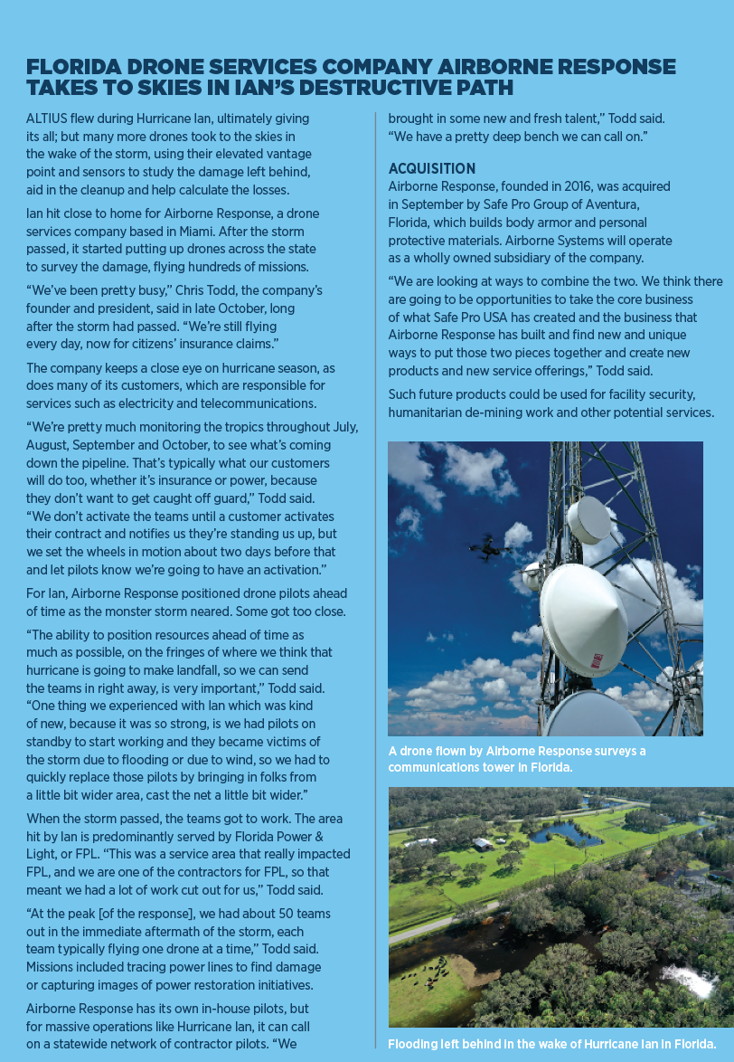
When Hurricane Ian came raging onshore in Florida in September, the National Oceanic and Atmospheric Administration (NOAA) had three unmanned systems waiting for it: two on the surface of the ocean and one in the air.
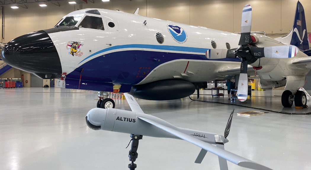
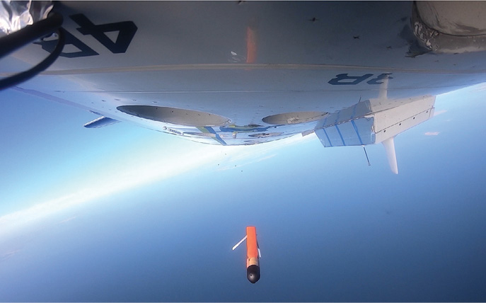
Led by Dr. Joseph Cione, the lead meteorologist for emerging technology at NOAA’s Atlantic Oceanographic and Meteorological Laboratory, NOAA researchers aloft in a WP-3D Orion launched an AREA-I ALTIUS-600 unmanned aircraft thousands of feet in the air, into the eye of the storm, the latest attempt in a years-long effort to measure and understand the boundary layer of the storm, where the storm meets the ocean and fuels itself. Down below, two unmanned surface vehicles from Saildrone maneuvered into place, with one managing to get into Ian’s eye as well. One thing researchers wanted to learn more about: how hurricanes can rapidly intensify, as Ian did. That can mean a storm hits a community harder than forecasters predicted, which can have disastrous results.
“The problem is, rapid intensification is pretty rare,” said Gregory Foltz, an oceanographer also at NOAA’s Atlantic Lab who worked with the Saildrone vehicles during Ian. “It only happens 5% of the time approximately, so just the sample size is kind of limited.” Ian ended up being a good test case, as it did intensify before landfall. “That was kind of a classic, classic case of why rapid intensification is dangerous,” Foltz said of Ian, which killed at least 127 people, most of them in Florida, and displaced many more in Florida, South Carolina and North Carolina. “And it happened to [hurricane] Michael too, before it hit the [Florida] panhandle a few years ago,” Foltz said.
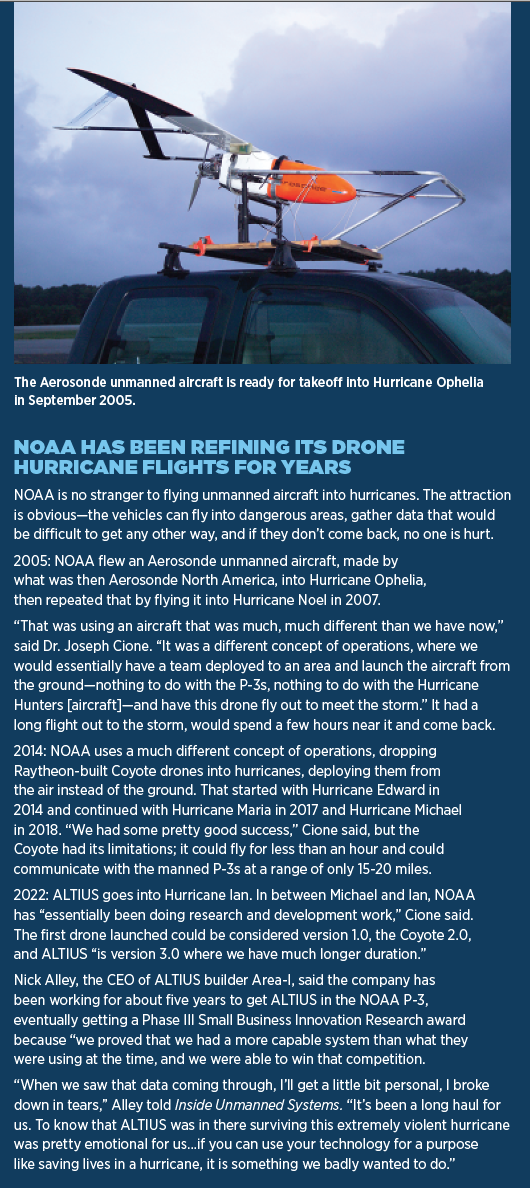
NOAA has been able to get the types of measurements the Saildrones made in the past, but it was a hit-or-miss proposition involving moored buoys.
“So, if the mooring happened to be in the path of a hurricane, and you could get these kinds of air sea measurements continuously through the hurricane, that’s really the only way that we could get that information in the past,” Foltz said. “There are a decent number of moorings in the Western Atlantic and the Gulf of Mexico, so it’s happened, but the advantage the Saildrone has is it has more comprehensive measurements than a mooring. And the key is we can direct them and we can move them into the path of a hurricane. And we’re getting better at that and getting more confidence and being able to do that consistently.”
NOAA has seven Saildrone Explorer USVs on patrol, with two of them being roughly in the path of Hurricane Ian, although one wasn’t in the best position. “During Ian, we had one Saildrone in the Northern Gulf of Mexico and we had one Saildrone off the coast of Florida, so kind of east of Daytona off the east coast of Florida. We were positioning those ahead of time. We had about a week’s notice based on the track forecast that Ian might be going up that way,” Foltz said. The hurricane track shifted, so one Saildrone didn’t get into the strongest winds, “but the one east of Florida, we did get through the eye of Hurricane Ian when it was a category one, as it re-intensified to the east of Florida, and it was in the perfect position to go through the center of that hurricane as it went along the Gulf Stream.”
UP IN THE AIR
While the Saildrones were battered on the surface, higher up the ALTIUS—which stands for Agile-Launched, Tactically Integrated Unmanned System—was showcasing how an unmanned aircraft could make storm measurements in winds so rough the manned P-3 aircraft was forced to fly farther away to stay safe yet still stay in contact with the drone. The ALTIUS carried the same sensors used in dropsondes, except for a downward-looking infrared sensor that measured sea surface temperature. The main advantage it brought is it allowed more time for measurements, which can be critically important.
“We did the penetration into the center of the eye and deployed the ALTIUS,” Cione said, as that is the easiest place to deploy a small drone in a hurricane. “It did a center fix. So, it estimated the center of the storm and then it proceeded to do what it’s built to, to fly very, very low in what we call the hurricane boundary layer, in areas that are unsafe for the P-3 to fly.”
The P-3 was getting battered by updrafts and downdrafts of 10-25 miles per hour, as well as winds that were making the plane move side to side, basically fishtailing like a car on a wet road. “Due to the turbulence we experienced on the way in on the P-3, we correctly made the decision to get out of the storm’s core environment and check, make sure we were okay, make sure there was no G forces that exceeded what we should be able to do,” Cione said.
“While we were doing that, the ALTIUS was operating on its own,” Cione said. “We want the drone to be able to fly a significant distance from the P-3 so the crewed aircraft doesn’t have to babysit the technology. And it worked, thankfully. Now, the P-3 went a little farther than we wanted to go because we weren’t expecting the crewed aircraft to exit the core of the storm, but it still worked. And it just goes to show that the engineers, both at Area-I and in NOAA, did a great job to have this platform perform like it did.”
In the eye, ALTIUS autonomously pursued its mission of measuring pressure, temperature, winds, turbulence, humidity and sea surface temperature, “flying controlled altitudes at about 250 to 350 feet, measuring what’s going on at that critical boundary layer region where the storm gets its energy, essentially evaporation from the sea surface and also gives information about near-surface winds, which the Hurricane Center wants.”
ALTIUS recorded winds as high as 216 miles per hour at 2,150 feet above the surface of the ocean, data of extreme importance to the National Hurricane Center in Miami, which was receiving it in real time.
At times, the communications link would drop, especially when the P-3 needed to get clear of the storm, and during those brief periods the ALTIUS flew to a prearranged spot at the center of the storm to reestablish it. In all, the ALTIUS provided nearly two hours’ worth of data, measuring atmospheric winds, temperature, pressure and moisture in one of the most dangerous environments on Earth. It can fly longer, but the hurricane winds cut its time, particularly when it was trying to reestablish its connection.
“This drone was fighting its way back to the eyewall. And at times it was flying against the wind. Now, we typically fly with the wind, that’s the most energy efficient way, you don’t want to fight mother nature. Keep in mind this is a 27-pound aircraft. At one point, we measured 216 mile an hour winds at 2,100 feet. …A couple of times it flew directly into the wind, but since the winds were so strong, it was literally flying backwards. It was really, really remarkable,” Cione said.
The ALTIUS can fly for up to three and a half hours under normal conditions, which Hurricane Ian definitely wasn’t. But even two hours was helpful, Cione said. “This drone stayed up for almost two hours. We think you can stay up three and a half hours. So, if it can do this, we have the analogy of sampling like its a movie versus what we normally get, namely a snapshot. As a result you’re going to have much better situational awareness of what’s going on down there.”
THE DATA
NOAA plans to eventually assimilate the data from ALTIUS and similar flights into weather forecasting computer models, along with the data from the Saildrones. The National Hurricane Center did look at the data from ALTIUS, “but we hope they will use it directly in their forecasts, and probably more important than that, is to share with emergency managers for decision-making processes,” such as calling for evacuations, Cione said.
ALTIUS carried sensors from Finland-based Vaisala that are already used in NOAA dropsondes and weather balloons, so the data would be consistent with existing NOAA operational models used to predict the structure and behavior of tropical cyclones.
NOAA Environmental Modeling Center researchers take the data and run it alongside the models in parallel, “to see how it’s doing.” The data will be fully incorporated into the models “when the modelers think it’s ready to be assimilated into routine operations,” Cione said.
The data does go into some models, the European and Canadian forecasting model, Foltz said, but the United States is more cautious thus far. “They have a different philosophy, a different system of data simulation and how to run their models,” he said, although he predicted it will be incorporated in the models in a few years.
ROUGHED UP
Hurricanes are rough on equipment, manned or not. The ALTIUS UAS was not intended to be recovered, and eventually crashed into extremely rough seas. “We’re flying over the ocean. There’s certainly no other planes or ships around. Everyone’s avoiding that area like the plague, understandably,” Cione said. “There’s no way for us to recover these drones.”
While the Saildrones survived, a similar craft was damaged during Hurricane Fiona, which hit parts of the Caribbean and eastern Canada in September. That is the point of using these systems, however: no manned vehicle would have survived what either ALTIUS or the Saildrones went through.
“We have other platforms that can make these measurements for sure, but there’s nothing else that I know of that can be steered, actively steered into a hurricane, make this comprehensive set of measurements and come out the other side transmitting all the data throughout the whole process and surviving and not, you know, sinking,” Foltz said.
FUTURE PLANS
Next year, ALTIUS will be joined by a sUAS from Colorado’s Black Swift Technologies, located not far from Cione’s office in Boulder. “The Black Swift S0, as it’s called, is much smaller,” he said. “It’s only three pounds, with a three- to four-foot wing span, but both the ALTIUS-600 and the S0 measure similar quantities, namely atmospheric pressure, temperature, wind, humidity and sea surface temperature as well as turbulent quantities. They will both be flying very low too. So, what they’re accomplishing is very similar. They just kind of do their jobs in slightly different ways.”
Black Swift Technologies also builds a turbulence probe, which will be outfitted on both the S0 and the ALTIUS-600 to “give us very high spatial and temporal resolution three-dimensional winds … we didn’t have the turbulence capability for the ALTIUS flight into Ian this year,” Cione said.
“We would like to get better height assignment. GPS is great, but GPS, particularly at assigning height at these very high frequencies, is not what we need because we have a rolling surface below us, waves that can be at one point zero and not long after, 30 feet or more. That’s a big difference … we want to put some sort of laser or radar altimeter on these platforms.”
Radar won’t fit on the Black Swift, but could on the ALTIUS. “We’ll get an altimeter and a turbulence probe next year. So, you’re going to have three dimensional winds, pressure, temperature, humidity, and the surface temperature, and of course we’ll always know where it is spatially thanks to GPS,” Cione said.
On the surface side, Foltz said, “we have a lot of ambitious plans for the future,” including again putting the same number of Saildrones in the water, two in the Gulf of Mexico and five in the Atlantic. With Ian, only one made it into the heart of the storm, but Foltz would like to have two in there next year to improve the data.
He’d also like to eventually team the Saildrones with the ALTIUS overhead and underwater gliders below.
“…One of our longer-term goals, that would be really most exciting if we could pull it off, is to have co-located measurements in the subsurface ocean from a glider, and then the air-sea interface from a Saildrone, and then the atmospheric boundary layer higher up from an aerial drone,” Folt said.