Topcon’s Global Approach to Integrated GNSS and Network Corrections
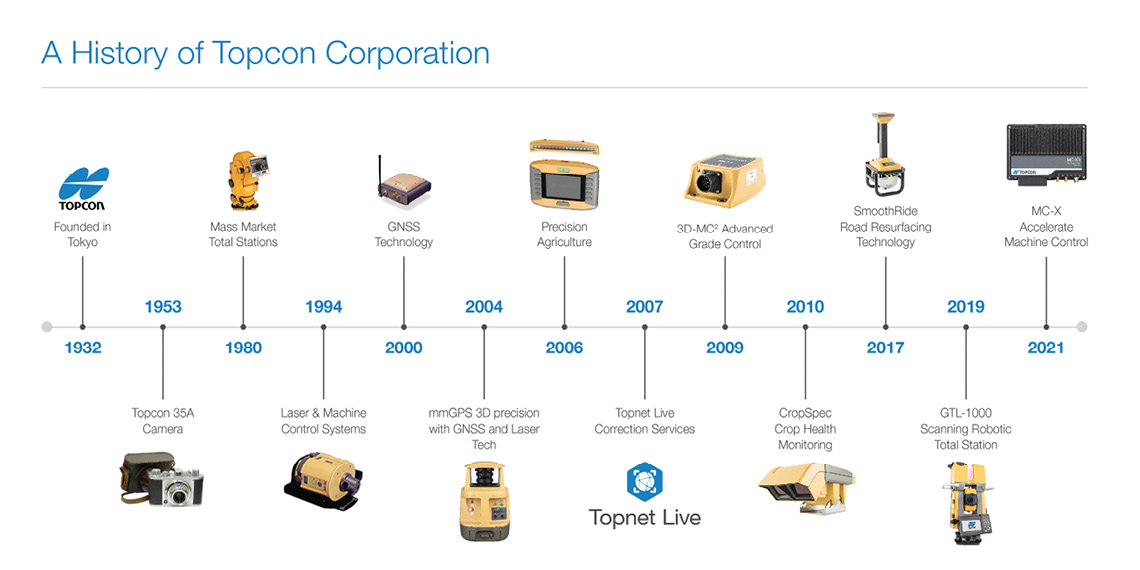
To trace the evolution of the global surveying and mapping industry over the last 30+ years is to map the history of Topcon Corp, and specifically, its subsidiary Topcon Positioning Systems.
From the introduction of the world’s smallest electronic distance meter (EDM) to the earliest mobile survey systems, the company has historically pushed the envelope with positioning innovations, focusing on the surveying, agriculture and construction industries.
Its reputation as an electronics innovator began with advancements in binocular technology, which led to the release of its first refractometer and the world’s first single-lens reflex camera with a through-the-lens (TTL) full-aperture metering system. Those innovations facilitated an early EDM solution for surveyors, the DM-C2, and more importantly, an eventual integration with the navigation and positioning power of GNSS.
Those explorations, investments and advancements have culminated in Topnet Live, a real-time GNSS network correction service that offers seamless connectivity for contractors, farmers and surveyors in an increasingly Internet of Things (IoT)-enabled world.

FOUNDATIONAL EXPERTISE
The Topnet Live service is a portal, an umbrella platform that encompasses multiple regional and country-wide networks.
It’s a service directly facilitated by Topcon’s decades of experience in optical technology, lasers and GNSS. That proficiency began when the company released its first GNSS receiver in 1990, and, around the same time, acquired a laser equipment manufacturer in the U.S. with an eye on developing machine control applications. Not long after, Topcon formed Topcon Laser Systems, Inc., now Topcon Positioning Systems, Inc.
The inclusion of laser instruments facilitated the advancement of 3D laser scanning, further aided by the acquisition of VOXIS, Inc., a company specializing in laser scanner technology and high resolution motion systems, as well as the introduction of the innovative GLS-1000, a surveyor-friendly standalone 3D laser scanner. Next came a mobile surveying and mapping system, the IP-S2, that gathers accurate positional data, consecutive images of surrounding areas and color 3D point-cloud data, all from a moving vehicle. The technology integrates state-of-the-art sensing technologies including high-precision GNSS receivers, inertial measurement units (IMUs), vehicle wheel encoders, 360° digital video cameras and laser scanners.
In 2000, Topcon’s technology teams began merging GNSS receivers with conventional surveying instruments—a move that led to the world’s first receiver capable of delivering millimeter-level accuracy. Then Topcon introduced the GRS-1 (Geodetic Rover System), the first fully integrated handheld GNSS receiver able to process both L1 and L2 signals while using an external PG-A1 antenna and with an electronic compass and digital camera to collect additional data.
It’s these early advancements that set the foundation for the development of Topnet Live.
FOCUSED ON FLEXIBILITY
The concept of Topnet Live began in the early 2000s as Topnet+ software with guidance from industry luminaries such as Dr. Clyde Goad, formerly a leading scientist at the National Geodetic Survey and professor at The Ohio State University.
Ian Stilgoe, Vice President, Global Emerging Business for Topcon Positioning Group, noted, “Reliability, accuracy and precision are critical elements of any quality correction service and achieving those capabilities requires very good geodesy, good modeling engines and good infrastructure, such as quality, stable, connected base stations. Without that foundation, a correction service is only good for best case scenarios—everything changes when we get to peak solar activity in a few years. When it comes to correction services, it’s important to know what’s under the hood.”
“The Topnet software collects GNSS data in real time,” said Dimitry Kolosov, Senior Fellow for Topcon Positioning Systems, based in Moscow. The data is sent to a software engine on the network that processes the data, prepares the model and uses it to generate network RTK solutions that can then be distributed to the rover receivers on the network that requests it.
Beyond the strong technical foundation of the Topnet+ software development, Tom Morris, Senior GNSS Product Manager at Topcon, recalled, “Our goal was to reduce the effort required by users to define real-time RTK networks. We wanted a portal that encompassed networks from around the world, but still maintains hierarchical approach across the system.”

In 2007, Topcon signed its first Topnet+ software customer, and a year later, rolled out the predecessor of Topnet Live in Southern California. Further, Topcon pioneered Topnet CORS, a subset of the complete software suite that offered 24-hour satellite coverage with GPS and GLONASS satellites. The service incorporated advanced signal processing techniques to reduce multipath and in-band signal interference for reliable operation in urban areas by generating GPS+ RTK data gathered from all reference stations.
By 2012, the Topcon network had expanded to include a European portal, a Russian portal and a North American portal, each including several larger networks. Currently, the portal supports Galileo, GLONASS, BeiDou and QZAA.
Kyle Snow, Director of Research & Development at Topcon, added, “Incorporating multiple GNSS constellations in Topnet Live was not an issue for us, because we had never released a GPS-only product. We had always made GNSS interoperability a high priority, so that as other constellations became available, we were ready to use their data.”
Topcon maintains a hierarchical approach not only on the Topnet level, but throughout the whole system. Each regional network is designed with redundancy, so that there is always a fallback, and the system self-regulates with load balancing. When an end customer connects online, he or she will be automatically directed to the server and network that are most appropriate for their subscription, for the coverage they are seeking and for the type of service they are looking for.
Continue reading (Part Two)…
To learn more – visit Topcon.