As with so many other market applications that require extensive data collection and precise measurements, drones have radically changed the face of both mapping and surveying. Some conflate the two, but they are different. While both aim to spatially depict the world, surveying remains subject to state licensure; mapping does not. Some drone service providers have been subject to claims of having crossed the line into “illegal surveying.” This article discusses the advanced technology that has impacted the topographical landscape and the laws that apply. It also provides tips on how to stay on solid ground when performing drone operations.
WHAT’S IN A NAME?
Words matter: “mapping” and “surveying” are different disciplines.
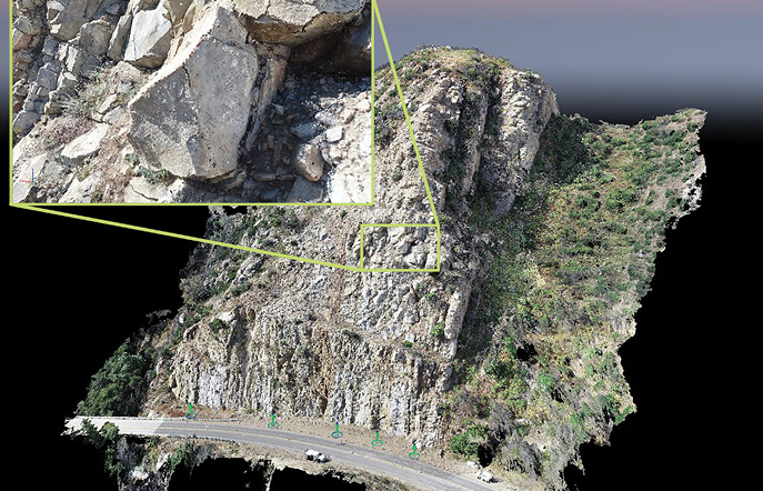
Basic cartography, or mapmaking, generally involves a large number of elements and processes where various points are matched against each other and depicted relationally as a two-dimensional (2D) representation of the world’s surface. A traditional topographic map depicts places using contour lines to illustrate terrain elevation, often shaded by hand. Today, computer software can generate these 2D digital elevation models.
Land surveying, on the other hand, determines terrestrial points, distances and the angles between them in 3D. Traditional surveying methods involve line-of-sight between optical/mechanical or digital electronic devices (theodolite) and a roving surveyor with a survey pole or target, a sighting telescope called a level, plane tables that establish the location of points on the ground relative to a baseline and a barometer to measure height above sea level. Digital electronic theodolites, referred to as total stations, combine distance measurement data from laser or infrared beams with internal/external electronic data logging. Modern total stations integrate GPS to provide precise position, navigation and timing (PNT). Modern surveyors might also use ground-based tripod mounted laser-scanners and computers/tablets. And a ton of math.
Perhaps the greatest distinction between surveying and mapping is that the former is a profession that requires a license. Each state has a licensing board that regulates surveyors. The names of these boards vary. For example, in Colorado, the Division of Professions and Occupations within the Department of Regulatory Agencies provides surveying licensure. In Texas, the Texas Board of Professional Engineers and Land Surveyors plays this role.
Obtaining that license requires specialized education and experience determined by each state. In North Carolina, an applicant without a surveying-related college degree must have 16 years of “progressive practical experience,” nine of them under a practicing licensed land surveyor. Applicants must pass three separate online exams totaling 20 hours and must submit a sample map complying with the state’s standards for the practice of land surveying.
To make matters more complicated, each state also differs in what constitutes the practice or act of surveying. Drone mapping expert Jared Janacek, CEO of txDroneCo, explained: “Some states like Colorado require a surveyor license to just tie a point on the earth to a local coordinate system. My home state of Texas requires a surveyors license to delineate property boundaries. This has been the challenge when it comes to producing topographic maps: Is this surveying?”
Disconnects between legal requirements and specific industry practices add complexity, said Jon Altschuld, founder and principal of Chinook Landscape Architecture in Centennial, Colorado. “In my world, Architecture, Engineering and Construction (AEC), tying a point to a coordinate system for the purpose of master planning, conceptual design or project visualization, does not require a surveyor license. On the other hand, tying a point to a coordinate system for construction document development, final design, property boundaries, etc. absolutely requires a licensed surveyor. But there is a lot of gray area in between.”
For both mapping and surveying, one thing has become crystal clear: drones have drastically increased the amount and accuracy of data collected, over larger swaths of ground and in a fraction of the time.
THE VALUE PROPOSITION
Using a drone to collect imagery produces 100,000 times more data than field data collection. Drones also gather better quality and larger quantities of data, which alleviates the need for do-overs. From collection to product delivery, incorporating drones and the right back end software speeds production to an average of 4 to 6 days, compared to the usual 2 to 3 weeks required for traditional methods.
“The benefits of aerial data collection also includes the fact that everyone involved on a project can have a thorough understanding of where things are actually located—and where they could be located—through 3D visualization,” explained Mark Taylor, CEO of Scottsdale, Arizona-headquartered Extreme Aerial Productions. “This can occur during the planning, layout, building and completion of any given project. Drones enable what I refer to as a ‘communicating collaborative’ at all stages of a project’s processes.”
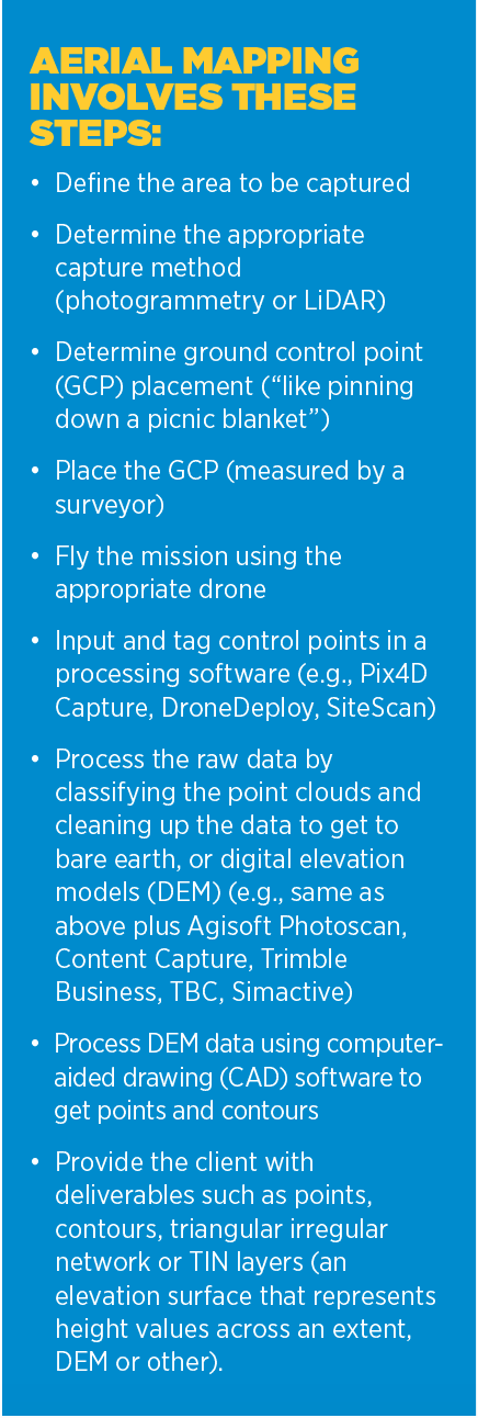
Like traditional methods of mapping and surveying, drone mapping operations also require specialized equipment and interfaces, such as:
• Ground Control Points (GCPs): Aerial observable targets measured with high-precision, to which operators can tie their digital models. Janacek said these could include do-it-yourself targets (e.g., marker paint, wood plastic or cardboard targets), targets that absorb GPS signals and log them for post processing against fixed observation sites (e.g. aeropoints, robopoints or others) and fixed landmarks (e.g., manhole covers, concrete seams, sidewalk intersections, etc.)
• GPS Receivers & Data Collectors: Usually GNSS receivers on a pole that syncs with a data collector to resolve ambiguities, process the observed data to calculate location and dynamically re-project points to the desired coordinate system
• Geodetic Datums: An abstract coordinate system with a reference surface (such as sea level) that serves to provide known locations to begin surveys and create maps (e.g., WGS84 is a global system that provides raw data from the satellites; NAD83, which is used across the U.S. for most XY measurements; and NAVD88, used across the U.S. for most Z measurements)
• Local Coordinate Systems: Local spatiotemporal dimensions in latitude, longitude, vertical or time dimension identified by a coordinate variable, often called state planes; these sometimes divide states into smaller zones.
• Real Time Kinematic (RTK): A GPS correction technology technique that provides real time corrections to location data as the drone is surveying and capturing images from a site.
• Post Processed Kinematic (PPK): A GPS correction technology technique that corrects location data after it is collected and uploaded.
These operations are difficult. Janacek explained: “We are trying to measure and represent the Earth in an accurate way. This is difficult to do because the earth is not flat, perfectly round or even precisely represented by any standard. Therefore, drone operators must have a thorough understanding of the various coordinate reference systems and measurement theories to effectively communicate with surveyors and engineers. Terms like datums, geoids, projections, translations, transformations need to be part of our lexicon so we can translate our data into language and systems that our clients understand and use.”
Taylor agrees: “The rubber meets the road on how the data is verified,” he said. “That’s what surveyors do. They provide us with their control to tie into during data processing. They verify that data by ground truthing it through checks and balances, within their comfort level of accuracy. That’s how you stay legal.”
FLYING WITHIN THE LINES
Understanding the legal landscape of the state in which you are operating will keep drone pilots from allegations of “practicing surveying without a license.” State surveying boards have issued these types of warnings to, and taken action against, drone operators in North Carolina, Mississippi, California and other states.
But the operators have struck back. Entrepreneurs Brent Melton and Scott Dow, co-founders of Vizaline, LLC, and represented by the Institute for Justice (IFJ), prevailed over the Mississippi Board of Licensure for Professional Engineers and Surveyors. Vizaline had been using drones to provide banks a cost-effective assessment of small properties put up as collateral for loans. The Mississippi Board considered this to be “unlicensed surveying.” In February 2020, the 5th U.S. Circuit Court of Appeals affirmed that First Amendment freedom of speech applied to such occupational licensing laws like Mississippi’s surveyors laws and sent the case back to the District Court for the Southern District of Mississippi for further proceedings. Ultimately, the case settled.
In 2021, Michael Jones, a Goldsboro, North Carolina-based photographer and videographer, and the state’s Board of Examiners for Engineers and Surveyors filed a similar case with the IFJ. Jones launched the suit after the NC Board issued an ultimatum for him to stop “mapping” based on its expansive view that simply collecting and disseminating information about land (e.g., dimensions, shape and size), constitutes the unlawful “practice of surveying” without a surveyor license. Jones is claiming, among other things, that this violates his right to freedom of speech under the First Amendment. The case still remains pending—putting Jones’ mapping business on hold for the past two years.
These extreme state board policies may be outliers, but operators should nevertheless understand the definitions and cases in the states in which they will fly. It is possible to reach out to a survey board and get an advance “ruling” about the classification of a particular job. Better yet, work directly with a licensed surveyor.
Janecek’s rule of thumb: “Give the data, not the interpretation.” He continued: “We work with surveyors. We know our role. We are drone service providers, acting under the direction of surveyors and engineers.”
“Stick to your scope of work,” Taylor added. “You are hired to collect aerial data within the bounds of your survey team’s guidance; you are just another tool in their arsenal. Collect it to the best of your ability and speak only to how your data is operating within your scope. Don’t talk about metes and bounds. Don’t offer opinions on boundaries. The only thing a drone pilot is surveying is the views and vista in front of him or her as they arrive on the jobsite.”
Circling back to the fact that words matter, Altschuld chimed in: “Discussing and defining terms with clients is important. I’ve had clients that repeatedly call what I’m doing ‘a survey.’ I will correct them every single time that it’s ‘mapping’ or ‘scanning,’ not ‘surveying.’ Eventually they catch on. I also put notes on most of my maps specifically saying ‘NOT A LAND SURVEY.’”
Piloting in support of surveying requires a nuanced balance of art and science, and an appreciation of the law. Tying those points together will provide a map to success.