The federal agency is using new systems to learn more about storm forecasting, greenhouse gases and atmospheric shifts.
You can steer them and you can get them back. In studies involving wind and sustainability, unmanned systems are becoming increasingly prized for their ability to survive dangerous conditions to be used again.
Since 2020, NOAA, the National Oceanic and Atmospheric Administration, has conducted an Unmanned Systems Operations Program to support the rapidly expanding use of these systems across the agency. NOAA continues as a major player in these activities, both through the NOAA Uncrewed Systems Operation Center in Silver Spring, Maryland, which responds to funding requests, and through other units, such as the Severe Storms Laboratory in Oklahoma.
Captain Phil Hall, director of the Uncrewed Systems Operation Center, noted that 2021 was a busy year. “We run an internal peer review grant process and this last year we had 39 proposals” for projects that would involve a NOAA principal investigator and other institutions, such as universities. Hall also promotes grants through NOAA’s SBIR (Small Business Innovation Research Program) that go to small, innovative private companies working to develop uncrewed systems for NOAA research applications.
Many of the projects the center funds contribute to sustainability and use drones to study wind in both its most violent and gentler forms.
HURRICANE HUNTING
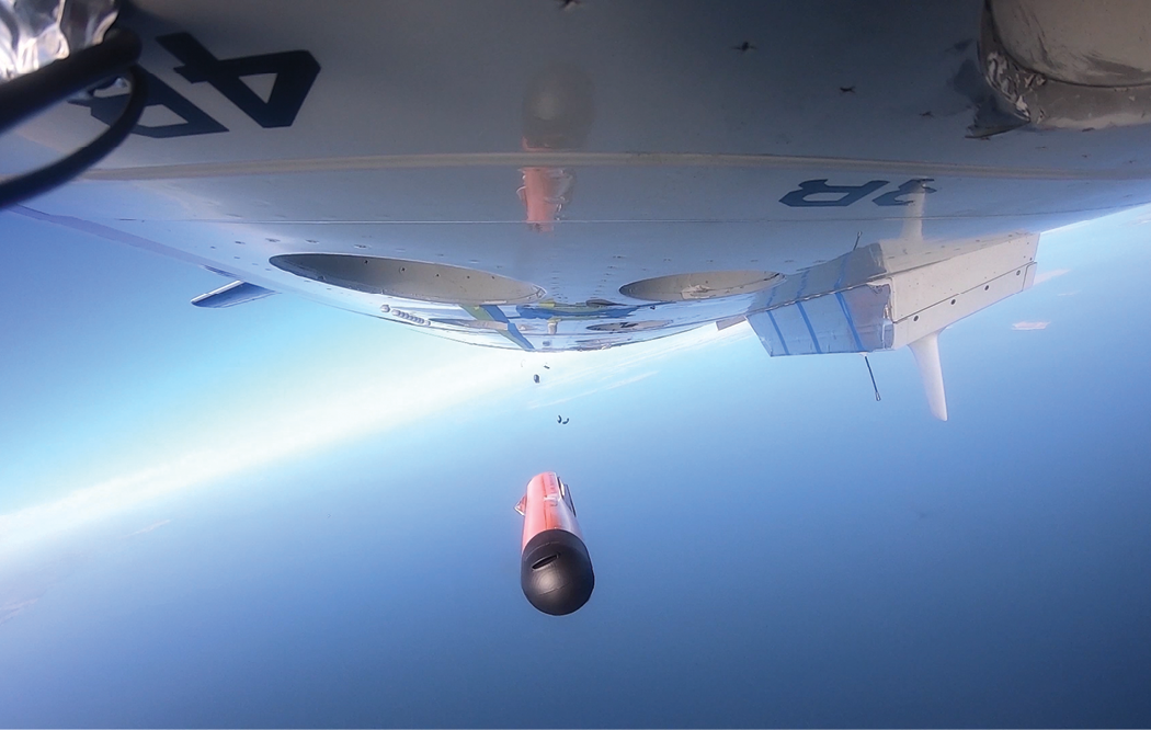
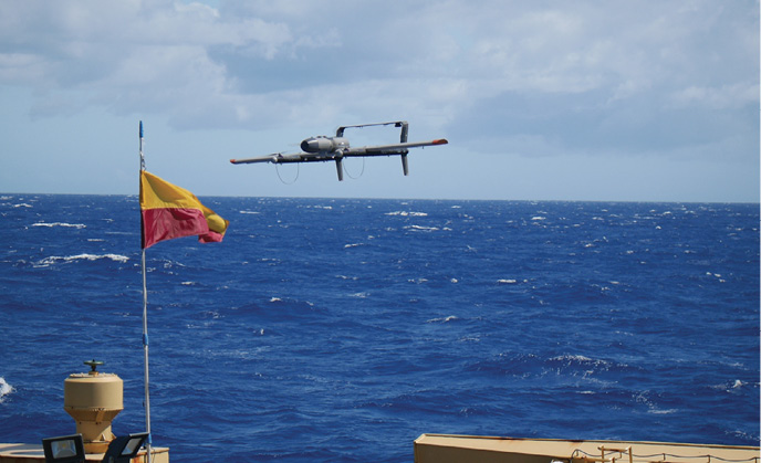
The violent interaction involves launching a drone from a manned aircraft into a hurricane, part of NOAA’s ongoing effort to determine how uncrewed technologies can improve forecasting ability. The concept of launching into storms was proven feasible using Raytheon Coyote drones launched from NOAA’s Lockheed WP-3D Orion “Hurricane Hunter” aircraft into major hurricanes Edouard (2014), Maria (2017) and Michael (2018). The Coyote, however, was limited in distance and other capabilities, and a call was sent out through the SBIR program for its replacement.
As reported in Inside Unmanned Systems in January, three potential replacements are on the list: Area-I’s Altius-600, Barron Associates Wingsonde and Black Swift Technologies SO. The Altius-600 has been tested over a field at the Patuxent River Naval Air Station in Maryland.
“Basically, we flew a couple of missions to test the range and we got record deployment distances of over 150 nautical miles in clear air,” said Dr. Joseph Cione, lead meteorologist, new technologies, of the NOAA Atlantic Oceanographic and Meteorological Lab. “We also took some measurements from the payload package for follow-up work.”
Then COVID hit.
“We’re getting back on track now,” Cione continued. “Besides ongoing analysis of the January test flight data, we’d like to solve some issues and be ready for test flights [of all three systems] in early 2022. That’s when we’ll be able to use NOAA’s P3 plane, which is currently busy with winter storms in Alaska. Hopefully we’ll be flying in hurricanes in 2022.”
Endurance has become crucial. Previously, NOAA’s WP-3D would drop expendable sensor packages called dropsondes, which would send back some data for short durations. “What we want to determine is if we could use UAS for a longer time and at very low altitudes within the hurricane’s most violent environment,” Cione said. The longer-duration drone, while still expendable, allows for additional data that the dropsondes are unable to provide.
“Our standard measurements include pressure, temperature, humidity, wind speed and wind direction,” Cione added. “We’re also measuring some things the dropsondes do not, such as sea surface temperature. By 2023, we’d like to also include a laser or radar altimeter that could give us information on ocean wave structure and provide us with finer vertical measurements than GPS alone. We also hope to obtain high resolution turbulence measurements that should lead to improvements within our forecast models.”
Right now, Cione is working with contractors to prepare for the flights. The primary integrator for the sensor packages is the Finnish company Vaisala and the small turbulence probes most likely will be by Black Swift Technologies out of Boulder, Colorado.
GLIDER SPIRALS AND SAMPLES
While the hurricane research looks at the characteristics of wind, other projects examine the content of the air itself. They can go to some unusual lengths to do that, such as dropping an unmanned glider from a balloon.
Sampling of greenhouse gases can be important tools as scientists work to sustain the atmosphere; use of weather balloons has been an important tool in that effort. Yet, “we throw away the instruments every time we launch a balloon,” said Dr. Colm Sweeney, of the NOAA Earth System Research Laboratories Aircraft Program. “We’re also limited in the quality of measurement we can get with disposable instruments. That’s what pushed us into developing a glider system.”
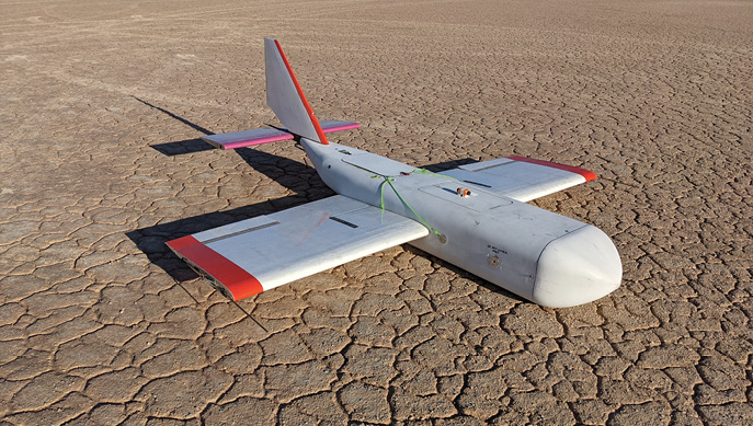
Sweeney is the principal investigator on that system—the High-Altitude Operational Returning Uncrewed System (HORUS) glider project, a new technology for high altitude air sampling and instrument recovery.
The system was flight tested last May at the NASA Armstrong Flight Research Center at Edwards Air Force Base in California.
HORUS, named after an Egyptian god whose name translates to “he who is above,” is a custom glider with portable fixed wings spanning six feet that carries an AirCore sampling system. The “high altitude” part comes because it’s launched from a standard weather balloon, rising to a height of up to 90,000 feet. Once the balloon pops, the glider can descend for a soft landing, taking measurements along the way. According to NOAA, the glider is the first of its kind capable of returning a 10-pound high-capacity scientific payload and other instruments from the stratosphere.
During the test flight, the balloon carried the HORUS airframe and released it at 75,000 feet. The glider, preprogrammed to a landing spot, spiraled down over it until, at 1,000 feet, a parachute deployed to land it yards from where it took off. In the test, it was also able to work through 60-knot winds it encountered at 40,000 feet.
En route, HORUS was able to collect a “core” of air vertically on its descent, to be measured afterwards for greenhouse gases such as carbon dioxide, methane and nitrous oxide.
While the glider is steerable and programmable to a location, it has no propulsion; hence the parachute. In fact, Sweeney said, “The faster it falls, the easier it is to steer.”
Sweeney reported that the concept can be used for many types of wind instruments and that measurements can be taken on the way up as well as down. Wind measurements usually involve use of GPS to determine movement.
Balloons and parachutes operate under a different set of FAA regulations than UAS. When HORUS is flying as a glider, even without propulsion, it may not fall completely under the balloon and parachute regulations. Sweeney said he is in talks with the FAA, discussing a “way to make it work.”
AIR ABOVE THE SEA
Dr. Patricia Quinn, principal investigator of the Atmospheric Chemistry Group of the NOAA Pacific Marine Environmental Laboratory, is also looking up.
She examines aerosol particles in the air and has measured black carbon to determine its role in warming the Arctic; its deposits on snow and ice increase melting. “We’re the people who make the measurements that help improve computer simulations and models of our climate,” she said.
“For years we’ve worked off ships,” she said, “and now we’re trying to develop a UAS that can do vertical profiles above the vessels. We want to see what’s happening above as well as at the surface.”
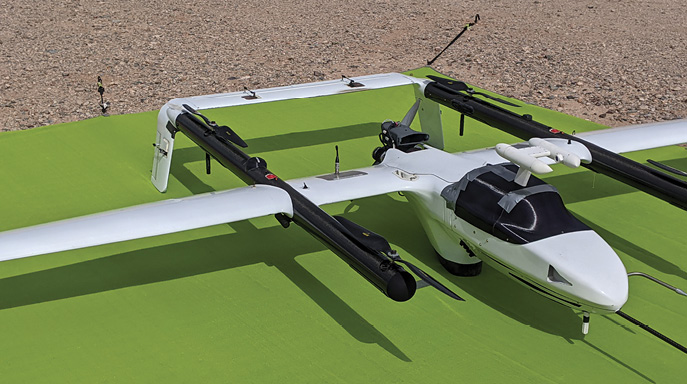
The UAS of choice here is the L3 Latitude LLC FVR-55 with a three-person crew. Latitude, now part of L3Harris, began as a separate company and was the recipient of a NOAA SBIR grant. The hybrid quadrotor takes off from a flight deck constructed on top of two containers on the fantail of a ship.
“Right now, we have two payloads that look at aerosols and we’re working with another recipient of NOAA’s SBIR program on further payload development,” Quinn said.
“We still haven’t used our payloads in an operational sense,” she said, although some test flights have taken off at a military range outside Tucson. “We’ve learned that our payloads are operational and we can go at least to 10,000 feet.”
“We’re hoping that in February or March of 2022 we can go out on a ship and do some vertical profiling.”
3D PRINTER TO 3D WIND
While these projects study wind and the atmosphere in various forms, another NOAA project is taking things to a whole new dimension.
We’re used to thinking of wind measured horizontally—in miles, kilometers or knots per hour. But knowing the vertical dimensions of wind can also be important. This year, at the NOAA National Severe Storms Laboratory and the Cooperative Institute for Severe and High-Impact Weather Research and Operations (CIWRO, a cooperative agreement between NOAA and the University of Oklahoma), a new algorithm was developed that allowed an unusual drone to deliver 3D wind measurements.
Tom Galarneau, a researcher at CIWRO, observed that “adding the third dimension of measurements provides a view of how the wind is mixing air masses in the atmosphere.” His team uses drones to study the lowest parts of the atmosphere, up to 5,000 feet above the ground. “Using unmanned aircraft helps us fill an observational gap,” he noted.
Early on, his team realized they needed a very specific drone, with an opening to channel the wind toward temperature and humidity sensors inside the drone’s body. In 2018, they created the first 3D-printed Coptersonde—adding helicopter blades and a battery to the printed body. Measurements taken include, Galarneau said, “temperature, humidity and most importantly, wind.”
The ability to measure 3D wind was developed this year when CIWRO researcher Antonio R. Segales Espinosa developed an advanced algorithm that used the drone’s physical movements and forces. “There are no dedicated wind sensors,” Segales Espinosa explained. “Rather, we measure the movement, tilt and thrust of the Coptersonde, which are combined into a dynamic model to provide the 3D wind vector.
“The reason we’re looking at vertical motion of the air is that it can give you an estimate of how the atmosphere is evolving and mixing between its layers. All of these measurements go toward a goal of learning about climate change and sustainability with a higher accuracy and increased awareness using a cost-effective solution,” Espinosa said.
The electronics inside the Coptersonde include temperature sensors made by International Met Systems, humidity sensors by IST AG and a CubePilot Autopilot Board. “The Cube software is open source so we can develop our own algorithms on top of theirs,” Segales Espinoza said.
Both Galarneu and Espinoza stressed the advantages of UAS in their work: reusability, retrievability and the ability to target the location of the desired samples.
As we hopefully head past COVID, NOAA is making sure wind research will continue to break new ground.