Skyline Nav AI’s Vision for the Future of Autonomous Navigation
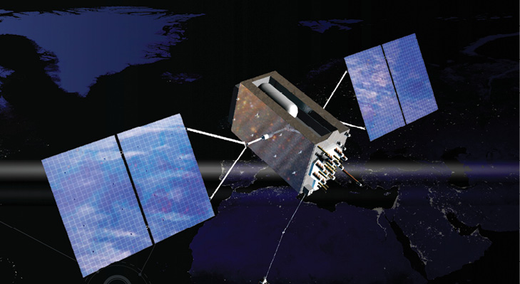
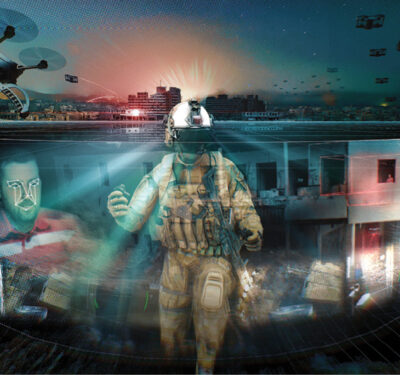
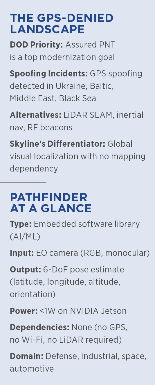
For half a century, GPS has been the linchpin of modern mobility. But the U.S. Department of Defense and industry alike are preparing for—and responding to—a world in which reliable access to positioning, navigation and timing (PNT) data is at serious risk. In sensitive and critical locations such as warzones, contested airspace or even dense cities, GPS is increasingly degraded, spoofed or denied entirely. As Kanwar Singh, founder and CEO of Skyline Nav AI, puts it: “Navigation is taken-for-granted—until it fails. Every year, the GPS environment becomes less reliable. We’re seeing jamming in commercial air corridors, spoofing attacks at sea. It’s not just defense. It’s shipping. It’s aviation. It’s our economy.”
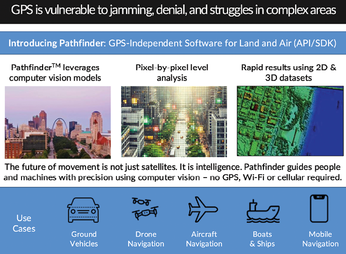
Skyline Nav AI, winner of Inside Unmanned Systems’ Innovation Vanguard Award for Best Start-Up, aims to solve that potential failure with an entirely different approach to navigation. Judges praised the team’s vision, technical maturity and national security relevance. Instead of relying on satellites, Skyline’s Pathfinder software uses computer vision and deep learning to determine location in real time, based solely on what a vehicle sees around it.
“It’s like giving autonomy a visual sense of place,” Singh said in an interview. “We’ve built a system that can tell you where you are in the world without GPS, without maps and without needing any network connectivity.”
MISSION BEFORE MARKET: A FOUNDER’S CALL TO SERVICE
For Singh, Skyline Nav AI wasn’t born in a boardroom. It was sparked by a phone call. Singh, on active duty in the Massachusetts National Guard, recounted, “I got a call from a senior officer I’d worked with before. He said, ‘We could be in a GPS-denied environment and we don’t have a solution. Can you help us?’ I said, ‘Is that an order?’ And he said, ‘You are an officer of the United States military.’ And I said, ‘Ready, sir. Moving, sir.’”
That moment set the tone for everything that followed. Singh viewed the problem not just as a market opportunity but a national imperative. “This wasn’t about chasing the next startup idea. This was about making sure our warfighters aren’t flying blind. They need to move, operate and survive when GPS is jammed or spoofed. That’s the mission.”
Today, that mission guides Skyline’s product development, defense partnerships and hiring culture. The company’s AI-based vision navigation system, capable of operating independently of GPS, is now being fielded across multiple domains and programs. But for Singh, the origin story still matters. “We started this to solve a real, immediate national security problem. And we’re still doing that.”
FROM HYPOTHESIS TO DEPLOYMENT
Skyline’s core product, Pathfinder, is an embedded AI software library that runs on compute modules already inside vehicles—from drones to ships to spacecraft. “We don’t build the hardware,” Singh said. “We integrate on the edge compute that’s already onboard.”
The software analyzes live imagery from a single EO camera feed. It compares this feed against a proprietary vision-based reference model of the world. This model is built using satellite imagery, synthetic renderings or pre-collected street-level data.
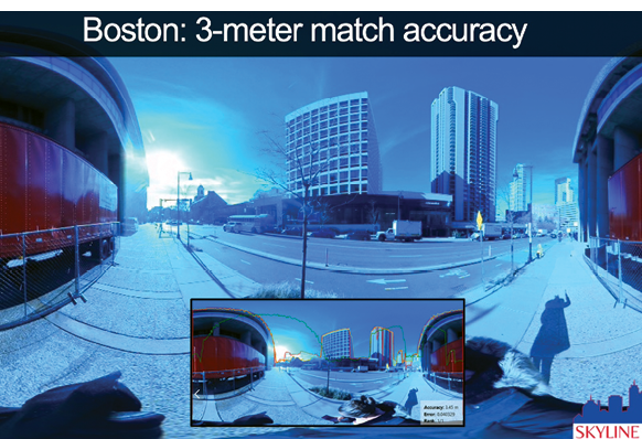
“From that, we’re able to output a pose estimate—your 6-DoF position and orientation—at centimeter-level accuracy,” Singh said.
Unlike Simultaneous Localization and Mapping (SLAM) methods that build maps dynamically, Pathfinder uses a global model. “SLAM is local and requires loop closure,” Singh explained. “We don’t. We can drop you anywhere in the world and localize immediately.”
Pathfinder’s model can incorporate simulated and synthetic imagery as well as real-world captures. “We can build reference data even for denied environments—like a port or base you’ve never mapped before—just using satellite renders and 3D reconstructions,” Singh noted.
WINNING IN THE DEFENSE SECTOR
Skyline’s first customers have been in defense, where GPS denial is not hypothetical—it’s happening continuously. Singh noted, “We’re already deployed on programs in the DoD where our system is used on the move, in tactical vehicles, in GPS-denied or spoofed environments.”
He couldn’t name the programs but confirmed that the company has partnered with major defense primes and integrators. “What they care about is trust. If they know it works under real-world conditions, in environments they can’t simulate, then we’ve crossed the bar.”
In March 2024, Skyline announced it had joined the AFWERX Autonomy Prime program and was selected for an Army SBIR contract focused on ground vehicle localization. Their technology also supports navigation at night, during GPS jamming or under foliage canopy.
“In our field demos, we’ve driven through tunnels, across canyons and down dense forest trails—places where GPS is blind,” Singh said. “We’re still localizing, still generating live pose estimates, without any fallback.”
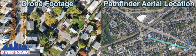
This performance has captured growing interest from programs that require contested-environment assurance. In one test, Pathfinder maintained centimeter-level accuracy through a 3-kilometer segment of an urban canyon completely cut off from GNSS.
More recently, Skyline participated in a DARPA-led evaluation simulating maritime GPS jamming. “We ran shipboard navigation off a single mast-mounted EO camera,” Singh said. “That camera was all we had—no INS, no GNSS, no LiDAR. And we held localization across the entire path.”
HOW IT WORKS
Pathfinder’s accuracy comes from fusing multiple neural networks. The software combines visual odometry, semantic segmentation, image-to-map registration and deep pose estimation. These components are fused via probabilistic methods to output a final location estimate.
“We call it visual PNT,” Singh said. “We can navigate anywhere you can see.”
Pathfinder doesn’t require LiDAR, stereo vision or inertial systems. “All we need is a monocular RGB camera,” Singh emphasized. “That’s how we can scale.”
The software runs in real time on NVIDIA Jetson modules or ARM-based edge devices. Singh said Pathfinder can deliver “full autonomy-grade positioning” with less than 1W of power draw.
“Visual-only is what lets us get into domains where size, weight and power are constraints,” Singh added. “That includes everything from battery-powered UAS to planetary rovers.”
The design also supports fallbacks in hybrid systems. “You can fuse Pathfinder with inertial, GNSS or other nav systems,” Singh said. “But if those go out? We still run solo.”
MAPS DON’T ALWAYS WORK
A key difference between Skyline and other autonomy stacks is its rejection of traditional HD mapping. “We don’t use maps,” Singh said. “They’re expensive, proprietary and fragile. You can’t trust that a map is up to date in a warzone.”
Instead, Skyline uses machine learning to interpret the world visually, in a way humans do. Their system isn’t brittle to environmental change. “You could knock over a building or start a wildfire—and we’ll still localize,” Singh said.
In one use case, Pathfinder was tested after a simulated infrastructure collapse. Buildings were removed from the training data to emulate disaster response conditions. “It didn’t matter,” Singh said. “Our system adapts—it reorients based on what it can still recognize.”
This resilience has applications far beyond defense. “In logistics yards, in airports, in tunnels—any place where maps go stale—we’re still online,” Singh said.
The team is exploring integrations with drone-in-a-box solutions for post-disaster survey flights. “When you don’t have maps, when infrastructure is gone, when it’s unsafe for humans—that’s when Pathfinder becomes essential,” Singh said.
FROM BATTLEFIELD TO FACTORY TO ORBIT
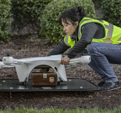
While defense is the lead customer, Skyline is branching into commercial sectors. One promising market is automotive manufacturing and logistics. “In large industrial yards or tunnels, GPS just doesn’t work,” Singh said. “Pathfinder can guide autonomous forklifts or yard trucks safely through those environments.”
Skyline has run pilot projects with Fortune 100 automotive manufacturers to guide autonomous material handling vehicles in GPS-blind zones. “What they care about is safety and repeatability,” Singh said. “We show them that we can run 24/7, in the dark, with no external infrastructure.”
The company is also engaging port operators and rail logistics firms. “Port automation is a perfect example—container yards are full of metal, with GNSS blocked or bouncing,” Singh said. “We make it possible to automate vehicle routing without having to rip up asphalt for beacon systems.”
Skyline is testing visual navigation for lunar and planetary rovers, as well. Singh said, “The problem is the same—localize from visuals in a sparse, unfamiliar terrain.”
Skyline’s architecture is designed to be domain-agnostic. Whether navigating an urban canyon or a cratered plain, the core model works the same.
THE ROAD AHEAD
Skyline is raising a new venture round to scale its engineering team and support demand. Singh believes the company’s core advantage is not just in the technology, but in its pragmatism.
“We’re not trying to boil the ocean,” he said. “We’re delivering something that works, today, under real-world constraints.”
Singh sees Pathfinder as part of a broader shift toward embedded intelligence. “Software is the new PNT infrastructure,” he said. “And resilience means designing systems that see and think for themselves.