When a plane attempts to land at the airport in poor visibility, signals from the instrument landing system (ISL) will help safely guide the aircraft to the ground. Such terrestrial air landing systems must be tested to ensure the navigation they’re providing is reliable.
Typically, that can be done through a ground based box that might be placed on a vehicle or benchtop, or a box that can be built into a flight inspection plane—with both performing the same tests but at different speeds, angles, heights and distances from the antennas that emit these signals.
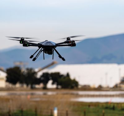
The new R&S EVSD1000 VHF/UHF nav/drone analyzer from Rohde & Schwarz gathers this data via drone. The signal level and modulation analyzer is designed for medium-sized drones and combines measurements from ISLs, ground-based augmentation systems (GBAS) and VHF omnirange (VOR) ground stations during startup, maintenance and servicing, and analyzes air traffic control communications (ATC COM) signals as well.
“With a drone, you can obtain measurements you weren’t able to get before with higher precision,” said Klaus Theissen, product manager for air navigation analyzers for Rohde & Schwarz. “Measurements that took half a day to complete in the past can be completed in half an hour, and the measurement itself only lasts 3 minutes. That’s much less runway blocking time so jets can land. Time is always money for the airport.”
The solution
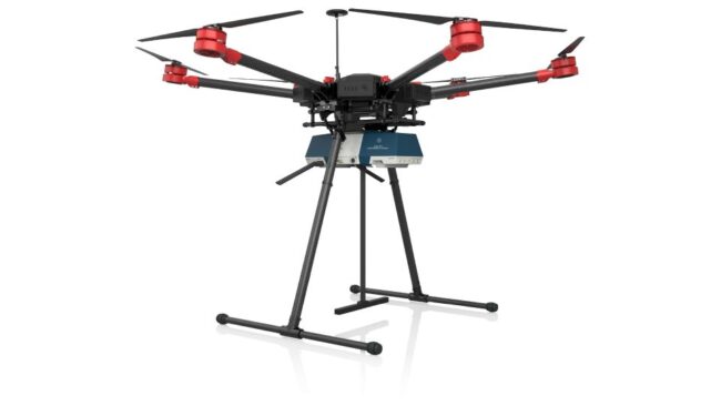
Rohde & Schwarz customers have used much larger drones to carry existing equipment for this type of testing, with boxes placed beneath the drone to take the necessary measurements. The results were promising, and the new box is light enough to fly on smaller drones, opening up more possibilities. The antenna weighs 150 grams and the box itself 1.5 kilograms. The quick release antenna can be mounted on top of the drone or below the receiver.
The EVSD1000 has the same capabilities as the ground based R&S EVSG1000 and the R&S EVSF1000 for installation on flight inspection planes, which include RF performance, ICAO compliance, high dynamic range, RX with two parallel demodulation channels and up to 100 measurements per second. It also has the same remote control interface as these boxes, making it easy to integrate the EVSD1000 for customers who already have the EVSG and EVSF versions and want to switch.
The box also offers gapless recording of measurement results, synced with GPS, I/Q data recording and streaming, as well as frequency and time domain analysis.
“We know the technology, the customers, the demand and the ICAO requirements, so we thought why not go out and use the knowledge we have and the instruments we have to build a drone version of our ground and flight inspection tools,” Theissen said. “And of course such a box for drone inspection must be lightweight and drone optimized. We wanted the same or better performance as our other products, and we needed something that was battery powered and modular because different customers have different demands.”
That led to the ICAO compliant EVSD1000 box, which features a mechanical and electrical design and provides real-time drone-based measurements of terrestrial navigation systems. High-precision signal analysis can be obtained in the 70 MHz to 410 MHz frequency range, which is critical for drone based terrestrial navigation signal measurement systems. The lightweight box features an aerodynamic shape, waterproof housing and various interfaces for easy integration.
The analyzer also provides the required measurement repeatability to ensure results from the drone measurements can be compared to flight and ground tests in line with ICAO standards, Theissen said.
Preparing for GBAS
GBAS is a possible ILS successor, Theissen said, and had to be considered in the new box’s design. GBAS is essentially a differential GPS for landing, with GBAS ground stations transmitting VHF data to approaching planes. The stations have a GPS receiver with two or four antennas with very precise location, making it possible to connect to a range of satellites and calculate a differential GPS message that can be sent to a multi-mode receiver with two inputs inside the plane. One input is for a normal GPS signal and the other is for the VHF data broadcast that contains corrections.
While GBAS isn’t used that often today, that’s expected to change, Theissen said.
“EVSD is prepared for that and can perform measurements on these signals,” Theissen said. “It can not only visualize signals, it also can perform measurements in time domain and frequency. It lists and stores the data in all the messages and gives the pilot the information.”
Moving forward
Rohde & Schwarz has completed measurements at airports with the new box, achieving even more stable results with the drone than with the ground inspection solution. The drone can fly in spaces where the signal is more stable, and can do so more efficiently and in less time.
“The impression is that 10 years from now very few guys will work with benchtop devices to measure on the ground,” Theissen said. “Most will use drone based systems for these measurements.”