As California grapples with its most devastating wildfire season in recent memory, the role of UAS in wildfire management has come into sharper focus.
While the extreme winds that fueled wildfires in California have largely grounded small UAS during the active blazes, UAS technology has proven invaluable in prevention and recovery efforts through critical mapping, inspection and surveillance operations.
This article explores how first responders have been deploying UAS before and after wildfires to enhance safety and mitigate damage through advanced mapping techniques and aerial inspections. It also addresses some of the ongoing research and development (R&D) efforts aimed at unlocking the full potential of UAS for surveillance and data collection during all phases of wildfire crises, from prevention to active firefighting and post-fire recovery.
CALIFORNIA’S FIERY WINTER: A SEASON OF DESTRUCTION
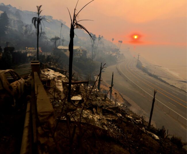
The 2025 fire season in California started early and with unprecedented fury. Since January 7, multiple fires have ravaged Southern California. The Palisades and Eaton Fires caused the most significant damage. The two fires collectively burned 37,469 acres, destroyed a total of 16,255 structures and damaged an additional 2,090 more. The total death toll from both has risen to at least 29 people. These fires also resulted in massive economic losses. Early estimates indicate they could be among the costliest wildfires in U.S. history.
As these unparalleled fires continued to rage, smaller blazes in the state also ignited. On January 22, the Hughes Fire popped up near Castaic Lake, in the Santa Clarita area. In just 24 hours, this blaze destroyed more than 10,000 acres. When added to the total area burned in Palisades and Eaton, these fires collectively burned almost 50,000 acres.
A perfect storm of conditions contributed to the rapid spread and intensity of these fires. Southern California has been exceptionally dry. Los Angeles County received literally no precipitation (0.00 inches) from late 2024 to early 2025. This drought, combined with Santa Ana winds that have reached speeds over 60 mph, created an environment ripe for the spread of catastrophic fires.

The extreme winds not only accelerated the fires but also severely hampered firefighting efforts, particularly aerial operations. With regular gusts exceeding 4o to 50 mph, conditions too dangerous for many aircraft, precluded small uncrewed aircraft systems (sUAS) from operating safely during response efforts. That said, in the realm of wildfire prevention, UAS proved to be a crucial tool for risk assessment and mitigation.
PREVENTION: UAS MAKING A DIFFERENCE “LEFT OF BANG”
The interface between wildlands and urban housing, known as the wildland-urban interface (WUI), remains a critical area of focus for fire prevention efforts. Fire departments and land management agencies increasingly use UAS to inspect and map the WUI. This helps to identify and mitigate fire risks and potentially reduce the likelihood and severity of catastrophic wildfires.
Andreas “AJ” Johansson, a Fire Captain with more than 30 years of experience who has served the Corona Fire Department in California since 2005, highlighted the value of UAS in pre-fire planning. He explained, “I can use UAS to inspect properties. Taking aerial shots of that urban interface allows us to visually assess potential fire risks and communicate them effectively to the public.”
Aerial inspections with UAS offer several advantages over traditional ground-based methods, which involve essentially “walking the line.” UAS provide a cost-effective solution to monitor vast areas of land. This makes it possible to conduct more frequent and thorough inspections without breaking the bank.
UAS can also more readily access difficult terrain or areas that might be either too challenging or dangerous for personnel to reach on foot. As such, they significantly enhance the safety of fire prevention operations by reducing the need for personnel to physically inspect hazardous terrains. In short, they keep firefighters out of harm’s way.
High-resolution aerial imagery from UAS provides a bird’s-eye view of the landscape for more comprehensive inspections.This vantage point can reveal potential fire risks that might not be apparent from ground level.
Finally, UAS can also swiftly gather and relay up-to-date information to allow fire agencies to rapidly respond to evolving fire risks. This potentially stops blazes before they spiral out of control.
This combination of efficiency, timeliness, safety and high quality data makes UAS technology an invaluable asset in modern wildfire prevention and management efforts.
But it’s not just about the superior data collected through UAS inspections and mapping; it’s all about the actionable insights derived from it that helps agencies determine appropriate prevention actions. High fidelity UAS-collected data can be easily integrated into existing geographic information systems (GIS) and fire behavior modeling software to improve overall fire management strategies. By combining UAS imagery with other data sources, agencies can create more accurate fire risk models, implement targeted prevention strategies and educate residents about wildfire preparedness.
UAS equipped with various sensors can provide detailed data on vegetation health, soil moisture and topography. This aerial inspection data can identify areas of dense vegetation or dead trees that pose a high fire risk. This information guides targeted fuel reduction efforts. Those efforts could include planning, executing (via aerial ignition) and monitoring prescribed burns, an essential tool to reduce fuel loads in forested areas. Johansson explained, “We do prescribed fires left of bang on the mitigation side. Lighting a controlled low intensity fire burns the potential fuel out of the area.”
RESPONSE: LIMITATIONS AND INNOVATIONS
UAS can provide real-time situational awareness during wildfires. This helps incident commanders make informed decisions about resource allocation and firefighting strategies. By way of example, the California Department of Forestry and Fire Protection (CAL FIRE) has been expanding its use of UAS for critical tasks such as wildfire containment and real-time assessments.
Extreme wildfire conditions, however, can limit the use or effectiveness of UAS during response efforts. Smoke, which can interfere with both visual and infrared imaging, presents challenges during active wildfires. In California, extreme winds largely grounded small UAS.
For these reasons, several government agencies continue to actively develop innovative solutions to tackle some of these limitations. For example, NASA is working on technology that could enable UAS and remotely piloted helicopters to fly simultaneously during wildfires, even when smoke and other factors reduce visibility.
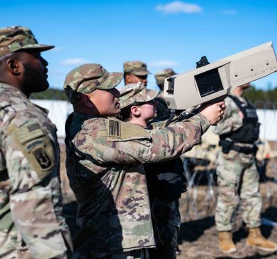
Johansson and several local California fire departments have been involved with the Department of Homeland Security’s (DHS) Science and Technology Directorate’s (S&T) collaboration with the University of California San Diego (UC San Diego) to evaluate WIFIRE Edge. This system can integrate data from various sources, including UAS and advanced sensor technology attached to firefighters and equipment, to gather detailed environmental data. It leverages edge computing and AI to generate accurate fire behavior models. When integrated with other technologies like the Team Awareness Kit (TAK), these models translate into accessible fire simulations, even to firefighters on the front lines. During several demonstrations, this tech improved situational awareness for fire management teams, including in areas with weak or non-existent internet connections. It also reduced simulation creation time from hours to minutes.
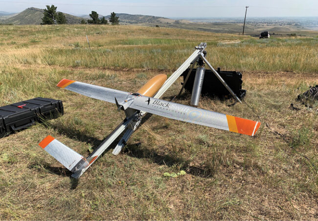
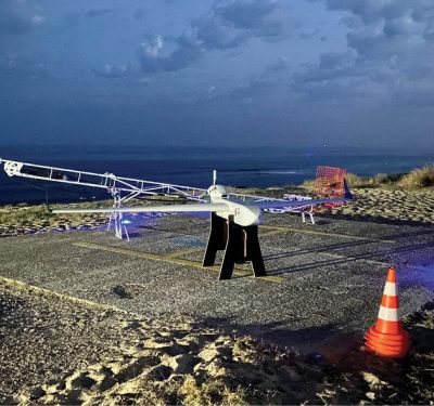
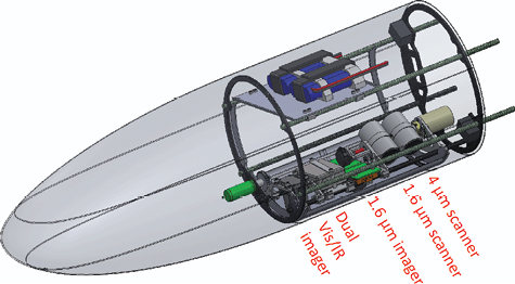
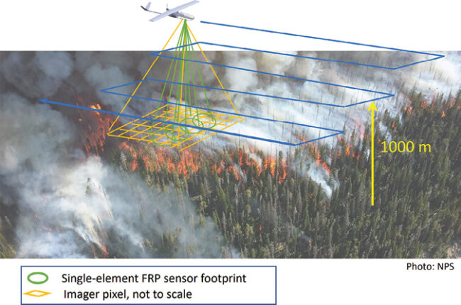
For its part, NOAA’s Chemical Sciences Laboratory (CSL) developed Nighttime Fire Observations eXperiment (NightFOX), a cutting-edge wildfire observation tool to address critical gaps in fire response. Designed as a lightweight payload for small fixed-wing UAS, NightFOX uses advanced infrared sensors and imaging technology to measure the extent and intensity of wildfires with sub-20 meter resolution from an altitude of 1 kilometer. Unlike traditional methods, which rely on expensive aircraft or coarse-resolution satellite data, NightFOX offers a cost-effective, high-resolution alternative, particularly valuable for nighttime observations when fires burn at lower intensity and other methods are limited. Its suite of instruments includes custom-built infrared telescopes, wide-angle imagers, a laser rangefinder and dual visible/infrared cameras. This enables detailed remote sensing without the risks or costs of in-situ measurements. Developed by a team led by Dr. Ru-Shan Gao and Dr. Troy Thornberry, in collaboration with Boulder, Colorado-based Black Swift Technologies (BST), NightFOX can provide wildfire managers with critical data to improve response strategies while reducing operational overhead.
BST, led by CEO Dr. Jack Elston, has worked not only with NOAA, but also NASA and several other agencies to develop UAS platforms capable of operating in extreme conditions relevant to wildfire management. Among other things, the company has developed UAS to both explore Venus’ atmosphere and observe volcanic plumes. BST has equipped these UAS with advanced sensors to measure wind velocity, atmospheric thermodynamics and particulate distribution, capabilities crucial to understanding fire behavior and predict its spread. The company is also working on integrating its technology with existing wildfire management software to provide a comprehensive solution for wildland firefighting.
All of these innovations provide incremental steps forward in our ability to tap into the full potential of UAS technology during the challenging response phase of wildfire fighting efforts.
RECOVERY: UAS IN THE AFTERMATH
In the wake of wildfires, UAS play a crucial role in damage assessment and recovery planning. Caltrans, California’s transportation department, has been using UAS to map areas affected by the recent wildfires in Los Angeles County. These aerial surveys can quickly provide accurate data on infrastructure damage. This helps the agency to prioritize repair efforts and allocate resources efficiently.
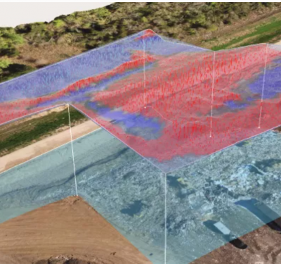
Johansson described his experience using UAS to create orthomosaic images of affected areas. These detailed, geometrically corrected maps have proven invaluable to assess the extent of damage and plan recovery efforts. Johnasson first encountered the large-scale use of orthomosaic maps during the Camp Fire in 2018. A team from the Bay Area used UAS to capture aerial imagery of the affected areas. These maps provided a comprehensive view of the fire’s impacts, crucial to initial damage assessment. So impressed with the tech, Johnasson used this data for his master’s thesis to further explore how to expedite the process of creating and using these maps for damage assessment. Now, he said, “Our team uses UAS to conduct post-event mapping missions, stitch the images and compress them with software and push the end product into the TAK server for download. It’s been working really well.”
While large-scale orthomosaic mapping often requires more substantial UAS or crewed aircraft, Johansson sees the potential to use smaller UAS for targeted mapping of specific areas of concern. This approach could provide rapid, localized intelligence to support recovery efforts as well as future fire prevention planning.
LOOKING AHEAD: THE FUTURE OF UAS IN WILDFIRE MANAGEMENT
In the face of increasingly severe fire seasons, the continuous innovation in UAS technology offers great potential to enhance safety of life through advanced mapping, inspection and surveillance capabilities. The recent California fires highlighted both the promise and current limitations of using UAS during wildfires. While extreme weather conditions may sometimes ground these aerial assets, ongoing R&D efforts promise to expand their capabilities and resilience. The integration of AI, advanced sensors, and robust communication systems will enable UAS to operate more effectively in challenging conditions, improving their ability to conduct critical mapping and inspection tasks. As these technologies mature, we can expect to see UAS play an even more crucial role in protecting lives and property from the devastating impacts of wildfires through enhanced surveillance and early detection capabilities.