“If you have a lemon, make lemonade.”
That vintage saying applies to Triad Drones in the age of COVID. Since opening in January, 2019, the nimble Safety Harbor, Florida-based firm had carved out a niche involving drone integration, inspection and data collection across the three domains of air, land or water. As owner/CEO Walter Lappert said when Inside Unmanned Systems profiled the company’s work on a problem-laden bridge in Jefferson Parish, Louisiana, last year, “I’m a drone company, but a lot of companies use me as a technologist, from computer set-ups to drone deployment.”
But just after that successful project, the lemon presented itself, in the form of the COVID pandemic. “We’re a service company, and because of the shutdown, we lost a lot of work.”
That hiatus, though, stirred the proverbial lemonade. “We had downtime and went into R&D mode,” Lappert added. The result is the newly fielded TRIDAR®, “a cost-effective air-land-sea solution for extremely accurate remote sensing applications,” and the optional Observer Quadcopter to fly it on.
Sensing a Solution
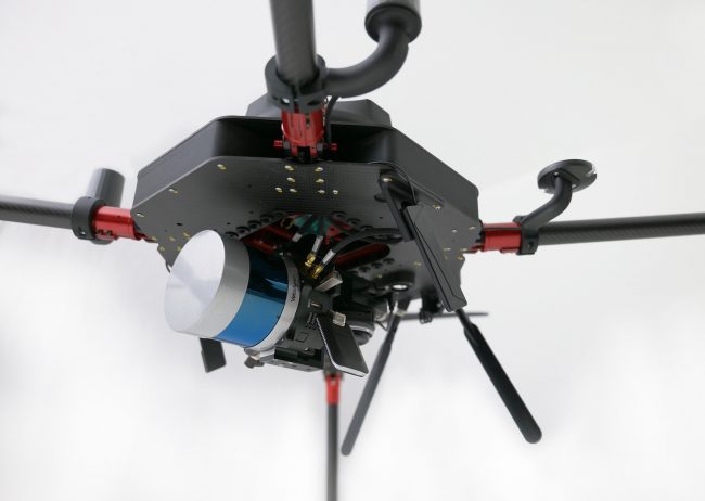
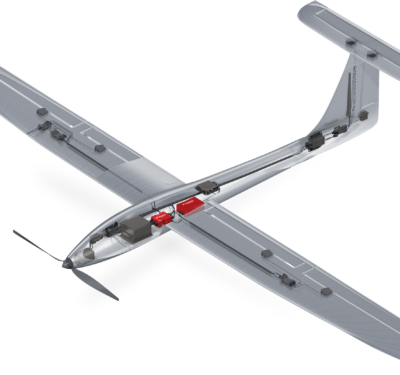
Triad Drones Observer Quadcopter mounted with TRIDAR®, Velodyne VLP32C, NovAtel RTK GNSS, Sony A6000, 4G LTE modem, providing a fully integrated solution for colorized point cloud modeling.
For Triad Drones COO Kamyar Shah, “TRIDAR is selectively designed so small shops can get the same-quality tools accessible to bigger shops at a faction of the cost, for on-par results.” And while TRIDAR is platform-agnostic, using it with Observer offers another triplet: what Lappert called “turnkey hardware and software, and training to support that.”
TRIDAR itself is a modular LiDAR-based system deployed with the goal of reducing complexity to collect useful data.
“We’re not making the actual laser itself,” Lappert explained. “Being specific about it, the laser is actually only one small piece of the whole system. Besides the laser, we have an IMU, a GNSS board and a data logger, all that together.” The LiDAR system offers accuracy of 2 centimeters for the total system, with a point cloud precision of 3.5 centimeters—at a price Lappert also maintained is significantly cheaper than other solutions.
“We have different laser head options,” Lappert noted. Users can supply their preferred GNSS receiver and/or LiDAR sensor head, and TRIDAR is compatible with Velodyne, RIEGL, Ouster, LIVOX, Teledyne and other scanners. Its LiDAR uses an Inertial Labs GPS-aided inertial navigation system with NovAtel’s RTK/PPK single or dual antenna(s) GNSS receiver, which in turn is integrated with a Linux-based processing platform that contains a WiFi interface, embedded cellular modem, datalogging software and gigabit ethernet.
Applications can range across construction sites, bridges and waterways.
In-flight Observer
While TRIDAR can be used with multiple vehicles, including boats, the Observer Quadcopter is offered as a congenial platform. “Lappert: “We’re making this solution, and then we also built a drone around that whole laser just under the 55-pound weight limit.”
Observer combines Dual RTK GPS for heading, secondary downward-facing LiDAR, an optical flow position hold sensor and other features. It can carry 15 pounds under Part 107. “We maximize the platform and built the vibration isolation system specified for that laser in a cage completely around the laser itself,” Lappert said. “So it’s actually built up tucked into the drone.
“We made as big a vehicle as we can, so we can fly as long as possible with a heavy payload and still abide by all the rules.”
Integration and Training
Complaints from customers about other companies leaving them in the post-purchase lurch also has spurred integration before, during and after purchase. “When someone gets this from us, they don’t have to put a puzzle together,” Shah said. “Assembly can be so much work, and there’s a risk of making mistakes. We’re one manufacturer providing hardware and software, an out-of-the box, usable system.”
Lappert agreed: “We provide everything for assembling, calibrating and bore-sighting TRIDAR. Us actually building the vehicle and the laser, and the software for it, they only need to talk to us.”
And then there’s training. “It’s not generic but on this hardware and software,” Shah said, “so the system can be used the way it was meant to be used.
Photo credit: Triad Drones.