Image courtesy of DJI.
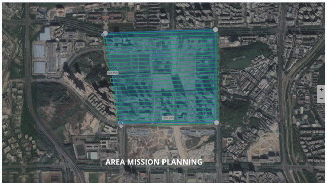
DJI has introduced new data visualization software called DJI Terra, which can generate 3-D models and maps from raw data and enables pilots to automatically plan flights based on the object or area the pilot wants to capture.
“As an all-in-one mapping and modeling solution, DJI Terra makes it simple and efficient to extract value from drone data, generating conclusions and recommendations across multiple use cases from crash reconstructions to critical infrastructure inspections as well as agriculture field mapping and construction site modeling,” Sunny Liao, DJI’s director of enterprise, said in a statement.
Flights can be planned with waypoints or by drawing a custom polygonal flight zone on a map. The software automatically generates efficient flight path options based on the area selected. The software also enables the pilot to adjust parameters like aircraft altitude, speed, heading, gimbal pitch and angle, the company said.
In addition a Terra-equipped drone can be set to fly the same route multiple times, adjusting the angle of the camera to capture new details each time. This technique gives “an extra crisp 3-D model of the object or asset from multiple angles,” the company stated.
Pilots will be able to generate 2-D orthomosaic maps as the drone flies. They can also do 3-D model reconstructions for industrial applications like reconstructing vehicle crashes, tracking progress on construction projects or conducting large-scale critical infrastructure inspections on bridges and roadways.
The software is compatible with Windows PCs and all current DJI Phantom 4 Series drones. More information is available at www.dji.com/dji-terra
A controversy about the security of DJI data arose in August 2017, with the U.S. Army banning the use of DJI drones. Shortly thereafter the Los Angeles office of the Immigration and Customs Enforcement bureau in the Department of Homeland Security wrote a memo saying the company was likely providing information to the Chinese government on U.S. critical infrastructure and law enforcement. DJI said in a statement to the New York Times cited in a November 2017 story that the report was “based on clearly false and misleading claims.”
Working to tackle the issue DJI addressed problems uncovered by security researchers in its security architecture and then hired the consulting firm Kivu to assess and report on its data security. “Kivu’s analysis of the drones and the flight control system (drone, hardware controller, and GO 4 mobile app) concluded that users have control over the types of data that DJI drones collect, store, and transmit,” said Douglas Brush, Kivu’s director of cybersecurity investigations, in an April 2018 statement.