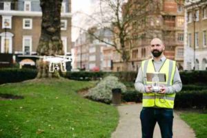
Paragon has launched what is believed to be the UK property industry’s first in-house drone service.
In an effort to deliver clients with faster, better and more cost-effective data, independent building and project consultancy Paragon has launched what is believed to be the UK property industry’s first in-house drone service following the recruitment of a highly experienced aerial surveyor.
Elliott Garrett joins Paragon — which has offices in London, Manchester and Edinburgh —following nine years’ experience working for Formula One Management. In his previous role, Garrett travelled the world planning Grand Prix race infrastructure and conducting precision GPS surveys of racing circuits using Global Navigation Satellite Systems (GNSS), laser scanners and unmanned aerial vehicles.
The innovative new service sits within Paragon’s building consultancy department and is already being used to produce condition reports on commercial and retail buildings in industrial estates, city centers and high streets, according to the company. The service provides Paragon’s clients with faster, richer and more cost-effective data compared to traditional models, and easier access to properties than access hoists.
Drone surveying works by combining high resolution GPS-tagged photographs, 4k video and photogrammetry software to create 3D models, site mapping, fly-over videos and roof surveys.
“When it comes to surveying, the property industry is a dinosaur that still uses slow, archaic processes. Embracing drone technology will be to the benefit of surveyors, developers, property funds and contractors alike,” Paragon joint managing director John Munday said of the drone service launch.
“We have collaborated closely with Elliott on a number of projects, so we know just how transformational, impressive and effective his approach is. Drone technology is a game-changer for surveying, so we are very pleased to be leading the way and collaborating with our clients to benefit their assets and create commercial advantage.”
Paragon also expects footage produced by drones to be used by clients to create impactful marketing videos, giving them a commercial advantage when selling or renting an asset. During construction projects, drones will also be used to replace time-lapse cameras to give accurate and real-time measurements of the mass of the site, helping avoid disputes about progress.
Commenting on his appointment, Paragon aerial surveyor Garrett, said: “Having worked closely with Paragon, I know it is a business brimming with innovation and ambition.
“Everyone here is always looking for new and better ways to work together with clients to provide them with the best outcomes. The drone surveying service has got off to a great start, and I’m looking forward to expanding our reach and its applications with the support of my colleagues and our clients.”
Elliott is fully insured and has all relevant permissions from the Civil Aviation Authority, according to Paragon.


