Photo credit: Aevex.
From February 6-9, Diversified Communications brought together some of the unmanned and autonomous industries’ leading professionals in Denver to showcase geospatial technologies at Geo Week 2022. This single event integrated the AEC Next Technology Expo & Conference, International Lidar Mapping Forum and the SPAR 3D Expo & Conference. Inside Unmanned Systems gathered insights from some top companies on-site about their cutting-edge technology and how it offers new possibilities, improved efficiencies and better outcomes. Here’s what they had to say.
AEVEX Aerospace / Geodetics
Big moves are afoot at Solana Beach, California-based AEVEX Aerospace, a recognized leader in full-spectrum airborne intelligence solutions. About a year ago, it brought on Geodetics to leverage its defense-grade mobile all-domain assured positioning, navigation and timing (A-PNT) systems and sensor fusion for the commercial mapping sector.
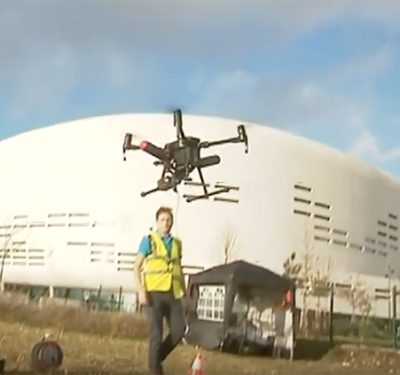
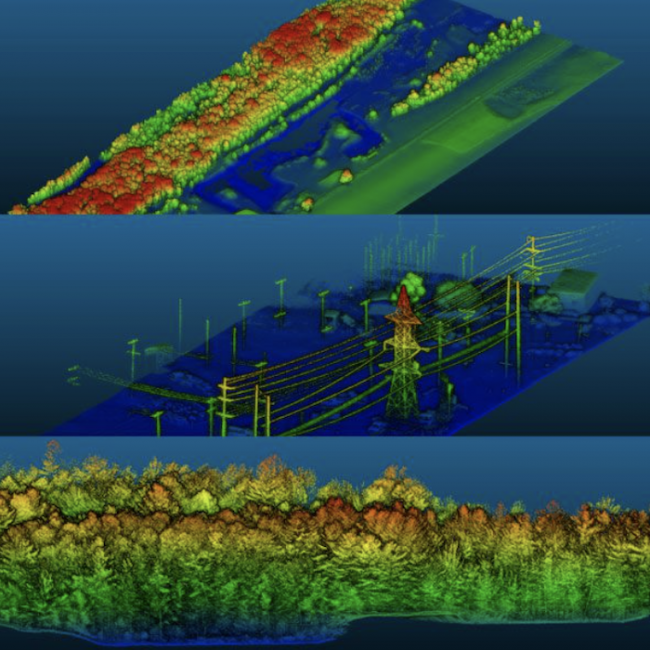
Robert Stadel, VP Geodetics, a U.S. Navy veteran with more than 20 years of experience in the defense and aerospace industry, made the move with Geodetics over to AEVEX. Stadel and the AEVEX team highlighted their Geo-MMS (Mobile Mapping System), a cost-efficient modular system for drone-based LiDAR and imagery capture solutions, and one-click advanced processing software for mobile and UAV-based mapping operations. Geo-MMS utilizes Geodetics’ defense-grade and lightweight battle-proven proprietary dual-antenna Inertial Navigation System (INS), coupled with LiDAR. On-site, the team showcased this 20-years-in-the-making tech, as integrated with an Inspired Flight drone. The system provides to-the-centimeter accuracy on point clouds for photogrammetry.
As for what’s next, Stadel said: “We are in full-on growth mode right now for PNT and LiDAR mapping. We are looking to build our team and our customer base.” AEVEX plans to integrate hyperspectral sensors, including IR, RGB, multispectral and other sensors, to further enhance its drone mobile mapping systems.
Hexagon / Leica Geosystems
Hexagon, a global leader in digital reality solutions, combining sensor, software and autonomous technologies, highlighted its new Leica Geosystems BLK2FLY drone. Fresh off the assembly lines in the fourth quarter of 2021, the BLK2FLY is the world’s first autonomous flying laser scanner with fully integrated LiDAR and advanced collision avoidance for autonomous reality capture.
The BLK2FLY scans building exteriors, structures and environments to create 3D point clouds while flying. Bryan Baker, Leica’s Sales Manager and an instrument rated pilot, FAA Certified Flight Instructor, Advanced Ground Instructor, Safety Team representative and mapping specialist, explained how it works: “The sensor informs the AI for the drone’s navigation. The drone actually learns about its environment while it is collecting.”
Perhaps even more novel, the BLK2FLY can work in tandem with “Spot,” the quadruped unmanned ground vehicle (Q-UGV) from Boston Dynamics. Leica calls its version the BLKARC, or Autonomous Reality Capture. The BLKARC will autonomously provide terrain-based capture including indoors in GPS-denied environments, and the drone will capture hard-to-reach exterior locations like roofs. The company’s Cyclone register 360 software integrates the workflow from these two different collection methods to generate interior or exterior 3D models, as well as detailed interior 2D floor plans.
The commercial use cases for the product target architectural, construction and engineering applications. “One client in the oil and gas industry is using the drone to facilitate add-ons to buildings,” Baker noted. “Another in the oil and gas industry will be using it in refineries to model flare stacks and tanks.” As for military applications, Baker said, the Air Force expressed interest in it to perform aerial scans for hard-to-get-to locations for crash investigations.
The company has already started shipping the BLK2FLY in Europe. It expects its first U.S. shipments to go out at the end of February.
YellowScan
French company YellowScan, designers, developers and manufacturers of professional grade UAV LiDAR systems, released its newest sensor, the Surveyor Ultra. An improved second generation of its original Surveyor Ultra, this one integrates Hesai’s XT32M2X scanner for high-density specifications for high-speed UAV and long-range needs.
The easy-to-mount lightweight Surveyor Ultra can mount on any UAV, including VTOL or helicopters. It was designed to fly in mission parameters as high as 90 meters above the ground to collect wide swaths (312 meters) at 5-30 meters per second for 3D modeling, with increased precision and faster data processing.
The 360° Field of View of the Surveyor Ultra’s Hesai XT32M2X laser scanner, when combined with the company’s Fly&Drive, provides for both aerial and ground-based mobile mapping using the same LiDAR. Fly&Drive is a versatile land vehicle-mounted or UAV-mounted mobile mapping system, which combines high resolution laser scanning and precise positioning to collect geo-referenced point clouds for a wide range of applications.
CTO Tristan Allous explained that the company added the Surveyor Ultra capability to its existing set of robust LiDAR solutions as part of continuous process improvement. Besides the Fly&Drive, the YellowScan suite includes: the Explorer, the Mapper+, Mapper, VX20 and VX15 series. He noted the Explorer, the first LiDAR that can be mounted on a light manned aircraft or helicopter and be switched to a UAV platform like the DJI M300, took five years to develop.
The YellowScan solution portfolio includes:
- All-integrated LiDAR hardware designed with laser scanner, IMU, GPS, embedded computer, batteries and data storage
- Software-enabling real-time in-flight LiDAR monitoring or georeferenced point cloud generation and visualization, customized to projects (output format is either LiDAR industry standard .LAS or .TXT)
- Services such as calibration, warranty, on-site training and worldwide customer support.
Allous noted that the company’s primary customers include photogrammetrists, surveyors and university researchers. Taking pride in the fact that YellowScan has been able to provide top-tier innovative products at affordable price points, he said that, “for the Surveyor Ultra, a comparable competitor’s system would cost three time as much.”
For the past 10 years, YellowScan platforms have been field-tested worldwide in multiple environments including tropical forests, bare soils, mountains, rivers, coast lines, open-pit mines and power lines.
The company continues to expand its global presence. Besides its home offices in France, it now has a presence in Germany, Japan and Australia. This past year, it expanded to Salt Lake City, Utah.