
SpearUAV has released the encapsulated Ninox 103 Sub-to-Air loitering UAS, which enables the underwater launch of submarine drones into the…
Inside Unmanned Systems
Event 38 Unmanned Systems Releases E400 Fixed-Wing VTOL Mapping Drone
Event 38 Unmanned Systems recently introduced the E400, a fixed-wing VTOL mapping drone with a payload capacity of 3 pounds….

Autonomy & Positioning Reality Summit earns IEEE accreditation, will provide credits as part of HxGN LIVE Global
The Institute of Electrical and Electronics Engineers (IEEE) recognises the education-first approach in Autonomy & Positioning Reality Summit sessions Hexagon’s…

Fugro’s lidar Geo-data supports OPW’s Irish coastal resilience strategies
The Office of Public Works (OPW) has awarded Fugro a contract to acquire, process and publish high-resolution lidar Geo-data of…
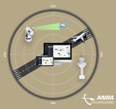
ANRA AWARDED CONTRACT TO TEST BVLOS DRONE OPERATIONS
SmartSkies safely integrating unmanned aircraft systems into the National Airspace ANRA Technologies was selected by Raytheon Intelligence & Space (RI&S)…
Atmos integrates Topcon’s hardware and correction services to create an all-in-one surveying solution
Atmos announces a new wide-ranging technical arrangement with Topcon Positioning Group for the supply of Topcon high-end GNSS boards for…

Five Good Questions: Joel Roberson
Joel Roberson is a public policy and regulatory partner at international law firm Holland & Knight. He focuses on public policy…

Inside Unmanned Systems Wins Prestigious Jesse Neal Award
Three other entries qualify as finalists The editorial and design staff of Inside Unmanned Systems has been honored for the…
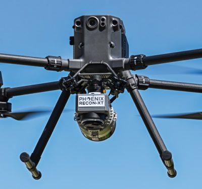
Use Case: Phoenix LiDAR RECON-XT
MORE-AFFORDABLE LiDAR SENSORS: A Real–world Deep Dive Explores Whether Smaller, Lighter LiDAR Solutions Deliver

Teledyne FLIR Develops and Collaborates on Bringing AI to the Edge
By Arthur Stout “Overcoming the Challenges of Bringing AI to the Edge” is a new, insightful paper authored by Arthur…
Transparent Sky Enters Wide Area Motion Imaging Market with First-of-its-Kind Sensor
United States Air Force taps into ability to view live 3D maps of any area Transparent Sky, a company pioneering…

Nocturne Drones Announces Cooperation with Dedrone and Expands Its Portfolio in Drone Defense Systems
Multi-award-winning drone show provider will use the leading solution for airspace security to protect events from unauthorized drones Nocturne Drones,…

The Domestic Counter-Unmanned Aircraft Systems National Action Plan
Over the last decade, unmanned aircraft systems (UAS or “drones”) have become a regular feature of American life. We use…

Textron Systems’ Aerosonde® Small Unmanned Aircraft System Takes First Flight from U.S. Navy Guided Missile Destroyer
Textron Systems Corporation has announced the successful first flight and maritime integration of the Aerosonde® Small Unmanned Aircraft System (SUAS) on…
Accelerate Development of Autonomous Vehicle Projects Through New By-wire Platform from Hexagon | AutonomouStuff
Accelerate development of autonomous transit shuttles, last-mile delivery and university R&D programs through new by-wire platform from Hexagon | AutonomouStuff…
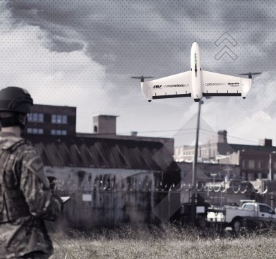
AeroVironment Donates Over 100 Quantix Recon Unmanned Aircraft Systems to the Ministry of Defence of Ukraine and Territorial Forces
Donation is independent of other AeroVironment systems already being provided to Ukraine by the United States Government Donated Quantix Recon…

Remote ID Meets Airspace Management
Pierce Aerospace, of Indianapolis, announced a partnership with Vigilant Aerospace Systems today to integrate Pierce Aerospace’s Flight Portal Remote ID…
