To the outsider, INTERGEO 2023 looks like most high-technology trade fairs – a lot of friendly engineers and marketers demonstrating sleek new machines to potential buyers who nod, graze on cookies, then drift downstream.
But the people who work the booths know better: it’s a jungle out there. With more than 1000 new products on offer in Berlin’s Messe, 500+ exhibitors are competing furiously for an advantage in the world’s rapidly evolving navigation and surveillance ecosystem.
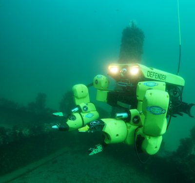
Some of those companies are even looking to nature itself for an edge. Take EvoLogics, a Berlin-based company that makes underwater acoustic modems and uncrewed autonomous vehicles.
“We do bionic engineering,” said Philipp Rasehorn, the Berlin company’s commercial project manager. For example, EvoLogic engineers based the shape and propulsion system of their first autonomous underwater vehicle on that of the manta ray and the shape of their next-generation system, the 1.5 meter Quadroin AUV, on the low-drag design of the hydrodynamic penguin.
EvoLogic’s communication system also takes a hint from the penguin’s calls as well, according to Rasehorn. Monotone sounds tend to be distorted in the water, which is why penguins’ underwater tones move up and down – a characteristic that EvoLogics engineers have copied in their acoustic underwater modems.
In another hall, Zurich aerial drone maker Wingtra added its own bird-like advantage to the latest model of its aerial drone: a sharper eye. Built in partnership with Sony, the new 61-megapixel lens has a wider sensor that makes it possible for WingtraONE GEN II drone users to take in a 40% larger field of vision than Wingtra’s previous 42-megapixel camera made possible.
Despite the bigger picture, taking a larger image actually speeds up processing, by reducing the number of images that need to be downloaded, according to Nina E. Müller, product marketing manager for Wingtra.
Atmos, a Dutch firm that specializes in geospatial surveying, is also finding better ways to see. The new payload of its latest Marlyn now includes an optional LiDAR sensor, which makes it possible to capture images that would otherwise be inaccessible, such as the ground hidden under tree canopies.
The addition of LiDAR has a second advantage as well – one that is likely to become more important in this era of record temperatures: it doesn’t require light. “You need sunlight in order to photograph things,” explained CEO Ruud Knoops, “so with a LiDAR, what that actually means, especially in areas during times when it gets really hot, you can avoid the hottest times in the day,” he said.
But there is more than one way of winning the evolution game: several of Atmos’ competitors are turning more toward military and security customers. “People go where the money is, so a couple of our competitors are focusing more on that – the geospatial market is like a side hustle for them,” Knoops said.
CHC Navigation is another company that is focusing more now on its LiDAR-powered offerings. François Martin, Vice General Manager of CHCNAV International, said the Shanghai-headquartered company has just released its own proprietary LiDAR after seven years of work.
Not far away, Emesent, a Brisbane, Australia LiDAR scanning and mapping company, introduced more robust autonomous capabilities for its LiDAR-powered sensors, including improvements to its SLAM algorithm and better data visualization.
Of course, developers are only half of what made the INTERGEO ecosystem compelling this year. Stefan Hrabar, CEO of Emesent, said that what he liked best were the knowledgeable consumers.
“What’s great for us being at a show like this is the quality of the conversations that we have, because people are pretty well educated and they know what they’re looking for,” Hrabar said. “It’s not just sort of a general, ‘what’s a drone?’ kind of thing. Everybody is either using drones or using laser scanners and it’s very easy to have a meaningful conversation with them.”