
Loon and HAPSMobile have developed a communications payload for HAPSMobile’s HAWK30, a solar-powered unmanned aircraft system (UAS) that flies in…
UAS
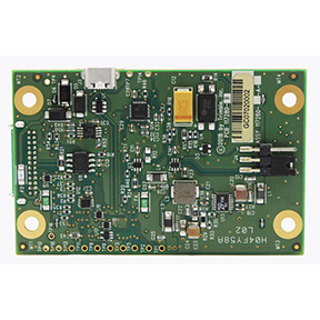
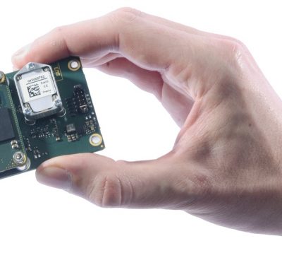
Trimble Launches UAS1 High-Precision GNSS Board
Trimble has introduced a compact, high-precision GNSS board designed for unmanned aerial systems (UAS): the Trimble UAS1.

UAV Commercial Expo Panelists Weigh In on Expanded Drone Operations
Eventually, drones will perform tens of thousands of missions a day, providing benefits to consumers who will have goods and…

Grand Challenges from NASA to Stimulate Urban Air Mobility
Jim Bridenstine, administrator of the U.S. National Aeronautics and Space Administration, announced at the Commercial UAV Expo in Las Vegas…

UPS Authorized for BVLOS, Effectively Launching Drone ‘Airline’
UPS, formerly known as the United Parcel Service, announced through its subsidiary UPS Flight Forward that it has received the U.S….
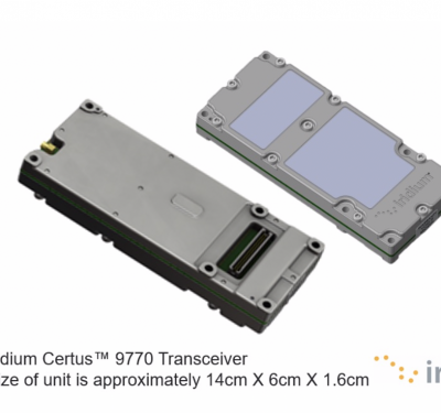
Iridium Certus Transceiver for Faster Satellite IoT, Data and High Quality Voice Applications Now in Live Testing
Iridium Communications recently announced the first 10 approved beta partners developing new products based on the state-of-the-art Iridium Certus 9770…

100+ Presenters, Panelists on Roster for Commercial UAV Expo Americas Next Month in Las Vegas
More than 100 thought leaders in the commercial UAS industry will present at the 5th annual Commercial UAV Expo Americas taking…

AiRXOS Successfully Completes UTM Pilot Program at FAA-Approved Test Sites
AiRXOS recently concluded real-world flight operations for the FAA’s first phase of the Unmanned Aircraft System (UAS) Traffic Management Pilot…

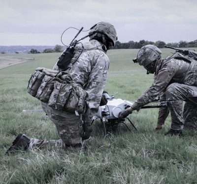
Counter-UAS Companies Marshall Forces to Support Government, Infrastructure
Response to the September 14 drone attack disabling oil processing facilities in Saudi Arabia comes from two U.S. providers of…
Applanix Enhances POSPac Trimble Post-Processed CenterPoint RTX Correction Service to Support UAV Mapping Without Base Stations
Applanix, a Trimble Company, announced Tuesday that the POSPac Trimble Post-Processed CenterPoint RTX™ (POSPac PP-RTX) correction service has been enhanced…
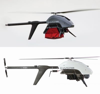
AeroVironment Unveils VAPOR All-Electric Helicopter UAS at DSEI
AeroVironment, Inc., a global provider of unmanned aircraft systems for both defense and commercial applications, announced the availability of its VAPOR…
Elistair Integrates Unmanned Ad-Hoc Networking from Silvus into its Tethered UAV Platform
Elistair and Silvus technologies announced September 16 that the companies have united their expertise to provide mobile-networked multiple input and…
New Quanta Series INS/GNSS Dedicated to Mobile Mapping Presented at INTERGEO
SBG Systems will present for the first time at the INTERGEO show in Stuttgart (Germany), the Quanta Series, a brand…
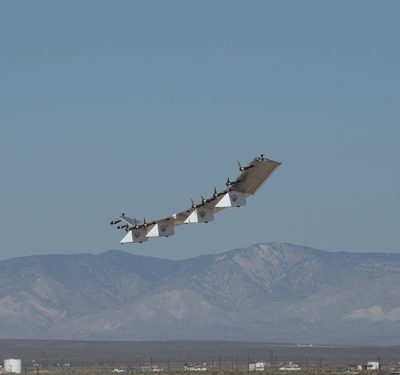
AeroVironment Achieves Successful 1st Test Flight of Next-Gen Solar HAPS UAS
AeroVironment, Inc., a global provider in Unmanned Aircraft Systems (UAS) for both defense and commercial applications, announced the successful first…
Drone Attack Casts U.S. Remote ID Rules in New Light
An alleged drone attack Saturday on Saudi Arabia’shuge Abqaiq oil processing facility could sharpen the focus on a long-delayed U.S….

CASSCA, PNT for Unmanned Systems Slated for Sept. 16-17
The Institute of Navigation’s Cognizant Autonomous Systems for Safety Critical Applications (CASSCA) Conference will feature well-recognized experts and leaders from…

Fortem Technologies OEM Agreement with Hewlett Packard Enterprise to Deliver Industry-First Custom Package of Drone Solutions
Fortem Technologies, Inc., a leader in airspace safety and security for an autonomous world, has signed an original equipment manufacturer…
