New airborne and bathymetric sensors extend range, precision, and real-time georeferencing for drone-based mapping and inspection.
At INTERGEO 2025, RIEGL introduced several additions to its airborne and unmanned LiDAR lineup under the company’s “Ultimate LiDAR™” banner. The new systems build on RIEGL’s multi-platform architecture for high-density 3D data capture from UAV, mobile, and terrestrial platforms.
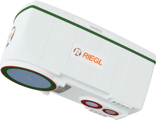
Leading the UAV-relevant releases is the VUX-820-G, an all-in-one topographic-bathymetric LiDAR sensor designed for integration on rotary- and fixed-wing drones. The 5.7-kilogram unit combines green-wavelength laser technology with a fully embedded RiLOC-F-inside GNSS/IMU module for direct georeferencing. The system records both topographic and shallow-water bathymetric data to depths of roughly twice Secchi depth and includes an RGB camera interface for simultaneous imaging. The compact design supports single-payload drone operations without external navigation boxes or separate power supplies.
RIEGL also announced that the RiLOC-F-inside subsystem is now standard across the company’s VUX-series sensors, including the VUX-100-25, -120-23, -160-23, and -180-24 models. The integrated inertial and GNSS hardware provides real-time trajectory estimation and tight coupling between navigation and LiDAR measurements, improving positional accuracy to within 2–3 centimeters after post-processing. By embedding the navigation unit within the scanner housing, RIEGL reduces overall payload weight and cabling, simplifying UAV integration and data handling.
Other airborne introductions shown in Frankfurt included the VQ-1060 corridor-mapping system, which combines oblique and nadir imaging with multi-directional laser scanning, and upgrades to RIEGL’s mobile and terrestrial product lines. The new VZ-1200i and VZ-6000i-26 terrestrial scanners extend the company’s range envelope to 6,000 meters while maintaining high-speed data acquisition.
All of the new instruments are supported through RIEGL’s existing software suite for waveform processing, calibration, and point-cloud generation. Data from UAV, mobile, and terrestrial sensors can be merged into common coordinate frameworks using the same post-processing workflow.
With these releases, RIEGL continues to expand its presence in the UAV LiDAR market, emphasizing compact design, integrated navigation, and interoperability across airborne and ground platforms. The company presented the systems publicly for the first time at INTERGEO 2025 in Frankfurt, where visitors could view the full range of “Ultimate LiDAR” solutions for topographic, corridor, and bathymetric applications.