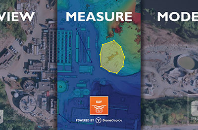
Multivista, part of Hexagon, will join forces with DroneDeploy to bring advanced project management capabilities to the construction industry via…
Survey

GEOINT 2019 Symposium Training Call
The United States Geospatial Intelligence Foundation (USGIF) is offering the opportunity to conduct training and education sessions during the GEOINT…

Airborne LiDAR Bathymetry Technology Allows Fugro to Survey Polynesian Island Country of Tuvalu
Fugro has been awarded a contract by the United Nations Development Programme (UNDP) to survey the Polynesian island country of…
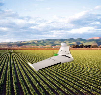
Delair Introduces the UX11 Ag UAS
The new UX11 Ag unmanned aircraft system (UAS) from Delair is specifically designed for large scale surveying in agriculture and…
Japan-based Terra Drone Acquires Significant Stake in Inkonova
Terra Drone, a global commercial drone technology company, has acquired a significant stake in Swedish aerial robotics for underground mining…

Dual Channel RTK for UAS Webinar Slated for Sept. 11
Today, high-precision GNSS technology is integrating with autopilot for guidance and control solutions for Unmanned Aircraft Systems (UAS) to deliver…

ASV Global and TerraSond Complete Unmanned Hydrographic Survey off Coast of Alaska
ASV Global and TerraSond recently completed an unmanned hydrographic survey for charting off the coast of Alaska, marking the fourth…
Drones Helping Mine Kafon Offer Mine Detonating Solutions
More than five years ago the brothers behind the Mine Kafon project—Massoud and Mahmud Hassani, received global exposure for “Mine…

NovAtel Launches New TerraStar-C PRO Multi-Constellation Correction Service
NovAtel Inc. today launched its new TerraStar-C PRO correction service with multi-constellation support, including the GPS, GLONASS, Galileo and BeiDou constellations. Combined…
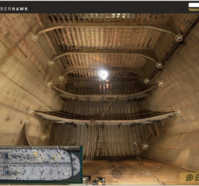
Cyberhawk Deploys UAS for First ABS Class Survey and Inspection of an Oil Tanker
Cyberhawk recently completed the first full ABS Intermediate Hull Survey 4 on an oil tanker with a drone. Inspections were…

Airobotics Showcasing its Fully Automated Drones at AUVSI Xponential
Airobotics, a global leader in fully automated industrial drones, today announced that it will showcase its drone platform at AUVSI…

In-House Drone Surveying Service Launch a First for UK Property Industry
In an effort to deliver clients with faster, better and more cost-effective data, independent building and project consultancy Paragon has…
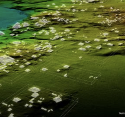
LiDAR Helps to Find Maya Civilization
DENVER—A lost civilization was found in the Guatemalan jungle recently with the help of LiDAR (Light Detection and Ranging) technology….

Cepton’s SORA 200 3D LiDAR Designed to Bring UAV Mapping to New Heights for Partner LiDAR USA
Cepton Technologies, Inc., a provider of 3D LiDAR sensing solutions for automotive, industrial and mapping applications, announced the launch of…

Surveying and Mapping: The Right Tools for the Job
As the unmanned sector evolves and more manufacturers enter the market place, buyers have an increasing array of hardware and software options to consider at various price points.
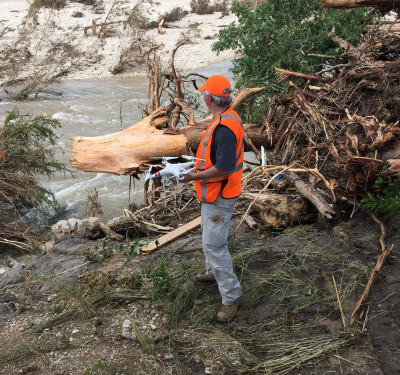
Lone Star UAS Center Sends UAS Research Team to Help with Flood Rescue Efforts in Texas
On May 25, devastating floods struck Wimberley, Texas, leaving four people dead in the county and at least eight missing. On…
Mapping the Course for UAS in Surveying
As unmanned aircraft technology continues to develop, geospatial professionals see the new capabilities, growth and efficiencies it can bring to their sector.
